Area Overview for Stone (Stafford)
Photos of Stone (Stafford)


Area Information
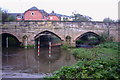
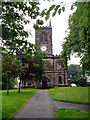
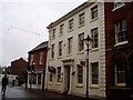
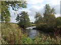
Stone represents a historic market town that blends deep medieval roots with the practical nature of modern Staffordshire living. Situated within the Borough of Stafford, this built-up area spans 5.6 km² and sits roughly 7 miles north of Stafford and 7 miles south of Stoke-on-Trent. The town's identity is defined by its status as a canal town, shaped significantly by the Trent and Mersey Canal during the Industrial Revolution. You can explore the rib-vaulted undercroft of Stone Priory beneath Priory House on Lichfield Street or visit the Common Plot, a wooded area known locally as the Mudley Pits. The Star public house, licensed in 1819, stands as a notable landmark that predates the canal's establishment. Stone Railway Station provides direct rail links, connecting commuters to Norton Bridge and Barlaston. This area offers a distinct setting where you can walk past historic sites like Westbridge House while accessing modern convenience. Living in Stone (Stafford) means residing in a community that values its heritage, from the medieval church of St Michael to the industrial legacy of the shoe trade. The town operates as a notable inland hub, serving residents with a balance of historical charm and functional transport connections to wider regions like Rugeley. You find a settled community here, anchored by specific landmarks rather than generic urban development.
- Area Type
- Built Up Area 250
- Area Size
- 5.6 km²
- Population
- Not available
- Population Density
- Not available
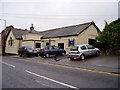
Residents of Stone (Stafford) enjoy convenient access to key retail and leisure amenities that define daily life. Within practical reach, you can find M & S Westbridge Park, Morrisons Daily, and Co-op Walton, providing essential shopping options without the need for long travel. The town offers five notable retail locations, ensuring you can stock up on groceries and essentials locally. Beyond retail, the area provides excellent rail links through Stone Railway Station, Norton Bridge Railway Station, and Barlaston Railway Station, giving you five nearby rail options for commuting or travel. You can walk or drive easily to these transport hubs, which also serve as social meeting points. The town's character is enriched by landmarks like the Common Plot, a wooded open area that offers space for walking and relaxation. Westbridge House stands as a historic reminder of the canal trade, while the Star public house offers local dining and socialising. Living in Stone (Stafford) means you have immediate access to supermarkets, train stations, and historic parks. This combination supports a self-sufficient lifestyle where most daily needs are met within the town limits. You can engage with the community through local shops and historic sites while maintaining efficient transport links.
Amenities
Schools
Families considering homes in Stone (Stafford) have access to several well-regarded primary schools within practical reach. The nearby schools include Manor Hill First School, Pirehill First School, St Michael's CofE (C) First School, Christ Church CofE (C) First School, and St Dominic's Catholic Primary School. Notably, Pirehill First School and St Michael's CofE (C) First School both hold a 'good' Ofsted rating, which provides concrete assurance of educational quality. This mixture of community and faith-led schools offers options for families with varying preferences regarding school ethos. The presence of these institutions suggests a local ecosystem designed to support school-age children, which benefits younger residents living in the 5.6 km² area. You can choose from Catholic and non-denominational options, though specific data on secondary schools is not included in the current information. The 'good' rating for specific schools indicates adherence to high standards in teaching and student care. Living in Stone (Stafford) means your children would have multiple local education choices without needing to commute further afield for primary schooling. The named schools provide a structured environment for upbringing, which is crucial for families settling in the town.
| Rank | School | Type | Entry gender | Ages |
|---|
Explore more schools in this area
Go to Schools tabDemographics
The community in Stone (Stafford) presents a clear demographic profile defined by an older resident population. The median age in the area is 70 years old, indicating a significant proportion of the population is retiring or retired. This age structure suggests a neighbourhood where you will frequently encounter elderly residents and established families. Historical data points to home ownership as the dominant housing tenure, with 72% of households owning their property outright or with a mortgage. This high rate of ownership typically correlates with long-term residents who have stayed throughout the town's evolution. While specific data on household composition types and predominant ethnic groups is not included in the current dataset, the high home ownership rate underscores the stability of the local population. The demographic picture aligns with the town's history as a place where families and later retirees have settled permanently. The most common age category listed in the available data relies on the total aggregate rather than specific bracketed ages. You should expect an environment shaped by older generations, which often means quieter streets and community engagement focused on established social norms. The 72% ownership figure is a concrete indicator that this area attracts buyers looking to settle rather than temporary renters. This demographic makeup supports local schools and amenities designed for a diverse age range, though the skew is heavily towards older demographics.
Household Size
Accommodation Type
Tenure
Ethnic Group
Religion
Household Composition
Age
Household Deprivation
NS-SEC
Explore more demographic insights in this area
Go to Demographics tabPlanning
Planning Constraints
- Crime RiskPremium