Area Overview for ST13 5AU
Photos of ST13 5AU
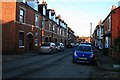
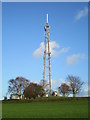
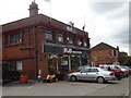

45 photos from this area
Area Information
Key information about the ST13 5AU including its size, population, and administrative classification.
- Area Type
- Postcode
- Area Size
- 4610 m²
- Population
- 1775
- Population Density
- 5913 people/km²
House Prices in ST13 5AU
22
Properties
£179,358
Average Sold Price
£20,000
Lowest Price
£350,000
Highest Price
Showing 22 properties
| Address | Type | Beds | Baths | Last Sale Price | Last Sale Date | |
|---|---|---|---|---|---|---|
| 55 Ashbourne Road, Leek, ST13 5AU | Terraced | 4 | 2 | £285,000 | Nov 2023 | |
| 69 Ashbourne Road, Leek, ST13 5AU | Terraced | 5 | 1 | £293,500 | Oct 2023 | |
| 45 Ashbourne Road, Leek, ST13 5AU | Terraced | 3 | 1 | £175,000 | Aug 2023 | |
| 63 Ashbourne Road, Leek, ST13 5AU | house | 5 | - | £297,000 | Jul 2022 | |
| 73 Ashbourne Road, Leek, ST13 5AU | house | 6 | - | £350,000 | Apr 2022 | |
| 43 Ashbourne Road, Leek, ST13 5AU | house | - | - | £175,000 | Sep 2021 | |
| 47 Ashbourne Road, Leek, ST13 5AU | house | 1 | 1 | £154,000 | Aug 2021 | |
| 41 Ashbourne Road, Leek, ST13 5AU | Terraced | 3 | 2 | £225,000 | Dec 2020 | |
| 71 Ashbourne Road, Leek, ST13 5AU | Terraced | 5 | 2 | £255,000 | May 2020 | |
| 65 Ashbourne Road, Leek, ST13 5AU | Semi-detached | 4 | 2 | £199,950 | Nov 2017 |
Page 1 of 3
Energy Efficiency in ST13 5AU
Amenities
Schools
| Rank | School | Type | Entry gender | Ages |
|---|
Explore more schools in this area
Go to Schools tabDemographics
Household Size
One person
most common
Accommodation Type
Houses
most common
Tenure
55
majority
Ethnic Group
White
most common
Religion
N/A
most common
Household Composition
N/A
most common
Age
47
median
Adults (30-64 years)
most common
Household Deprivation
N/A
with no deprivation
NS-SEC
28
in Lower managerial occupations
Explore more demographic insights in this area
Go to Demographics tabPlanning
Planning Constraints
- Flood RiskPremium
- Ramsar Wetland SitesPremium
- Area of Outstanding Natural BeautyPremium
- Protected Nature ReservePremium
- Protected WoodlandPremium