Area Overview for Norbury
Photos of Norbury
Area Information
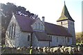
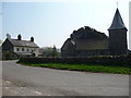
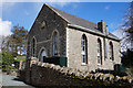
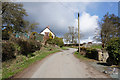
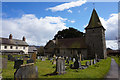
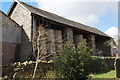
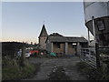
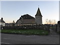
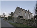
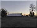
Norbury is a small civil parish located in Shropshire, spanning an area of 9.4 km². It sits to the west of the Long Mynd and near Bishop's Castle within the West Midlands region. The landscape includes three distinct townships: Asterton, Whitcott, and Hardwick, which all lie within the Onny Valley. You will find the parish roughly positioned at 52.529°N 2.939°W. This setting defines daily life here as quiet and rural, removing residents from the noise of major cities. The village centre centres around the active parish church of All Saints, which holds a significant position in the community history. The church features regular services including morning prayer on Wedn esdays and holy communion on Saturdays and Sundays. For visitors seeking overnight stays, The Coach House operates as a country house B&B. The name itself derives from the Anglo-Saxon 'North fortification', hinting at early defensive structures near the hill fort defences. The current All Saints nave, chancel, and spire were constructed between 1880 and 1892 by Henry Curzon. This building stands atop a 14th-century west tower that remains part of the historic fabric. Records dating back to 1560 show Norbury was a chapelry of Lydbury North Ancient Parish with a church dedication to St Ethelbert noted from 1521. The original structure was built around 1200 but rebuilt in 1723 before the current work began. These historical layers provide context for the village atmosphere you experience when driving through the three townships of Hardwick, Whitcott, and Asterton.
- Area Type
- Parish
- Area Size
- 9.4 km²
- Population
- Not available
- Population Density
- Not available
Demographics
The community in Norbury reflects a mature population with a median age of 70. This figure indicates that you are likely to live amongst senior residents rather than a younger working demographic. The most common age range uses the total age category as its primary metric, confirming that the entire population skews older on average. Home ownership stands at an exceptionally high level of 79%, suggesting that the vast majority of houses in Norbury are privately owned by long-term residents. This statistic implies a stable environment where families and individuals have settled in their properties for extended periods. You will find few rental properties or student-led housing options compared to larger towns. The household composition data uses a total classification, meaning there are no specific breakdowns for single-person vs family units available in the current records. Similarly, accommodation type data is aggregated under a total category without distinct breakdowns for detached, semi-detached, or terraced stock. Ethnic group and religious affiliation data are also provided only as total figures, lacking the detailed segmentation seen in urban areas. Despite these aggregated categories, the area maintains a cohesive character typical of rural villages in Shropshire. The high ownership rate of 79% strongly suggests that financial assets are tied up in land and brick rather than rented accommodations. This profile often correlates with lower churn and stronger local governance participation.
Household Size
Accommodation Type
Tenure
Ethnic Group
Religion
Household Composition
Age
Household Deprivation
NS-SEC
Explore more demographic insights in this area
Go to Demographics tabPlanning
Planning Constraints
- Flood RiskPremium
- Ramsar Wetland SitesPremium
- Area of Outstanding Natural BeautyPremium
- Protected Nature ReservePremium
- Protected WoodlandPremium