Area Overview for HR8 2WE
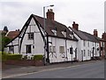
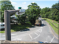
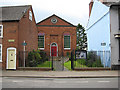
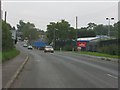
Photos of HR8 2WE


Area Information
HR8 2WE is a small, tightly knit residential cluster in England, home to 1,647 residents. Its compact size means it feels like a quiet, self-contained community, with easy access to nearby towns and amenities. The area is well-served by two railway stations—Ledbury and Colwall—offering regular connections to larger cities like Worcester and Birmingham. Retail options are conveniently located, with Aldi, Tesco, and Co-op stores in Ledbury just a short trip away. Broadband here is excellent, with a score of 100, ensuring fast and reliable internet for both work and leisure. Mobile coverage is good at 80, supporting everyday connectivity. Daily life in HR8 2WE balances rural tranquillity with practical access to services. The low crime risk score of 89 makes it a safe place to live, while the absence of environmental constraints like protected woodlands or wetlands means development is straightforward. This area suits those seeking a peaceful, family-friendly environment without sacrificing convenience. Its small size and proximity to transport hubs make it ideal for commuters or those who enjoy the best of both town and country living.
- Area Type
- Postcode
- Area Size
- Not available
- Population
- 1647
- Population Density
- 4056 people/km²
The property market in HR8 2WE reflects its small, residential character. With a population of 1,647, the housing stock is likely limited to a mix of traditional homes, though specific data on home ownership or accommodation types is not provided. The area’s compact nature suggests a focus on owner-occupied properties, given the lack of planning constraints that might encourage rentals. Buyers should consider that the immediate surroundings may offer similar housing options, but the precise balance between rental and owner-occupied properties remains unclear. The absence of large-scale developments or commercial zones means properties here are likely to be more modest in size and number. For those seeking a quiet, low-maintenance home, HR8 2WE’s limited scale could be an advantage, though buyers should assess the local market carefully to understand availability and pricing trends.
House Prices in HR8 2WE
No properties found in this postcode.
Energy Efficiency in HR8 2WE
Living in HR8 2WE offers a blend of convenience and simplicity. The nearest retail options include Aldi, Tesco, and Co-op in Ledbury, providing essential shopping within easy reach. While the area itself is small, its proximity to Ledbury and Colwall ensures access to more extensive amenities, including dining and leisure opportunities. The absence of large parks or recreational facilities within HR8 2WE means residents may need to travel a short distance for outdoor activities, though the surrounding countryside likely offers walking and cycling routes. The character of the area is defined by its quiet, residential nature, with local shops and transport links supporting a low-key lifestyle. This makes HR8 2WE ideal for those who prioritise ease of access to services without the bustle of larger towns.
Amenities
Schools
| Rank | School | Type | Entry gender | Ages |
|---|
Explore more schools in this area
Go to Schools tabDemographics
Household Size
Accommodation Type
Tenure
Ethnic Group
Religion
Household Composition
Age
Household Deprivation
NS-SEC
Explore more demographic insights in this area
Go to Demographics tabPlanning
Planning Constraints
- Flood RiskPremium
- Ramsar Wetland SitesPremium
- Area of Outstanding Natural BeautyPremium
- Protected Nature ReservePremium
- Protected WoodlandPremium