Area Overview for HR6 8AH
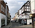
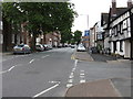
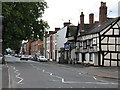
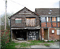
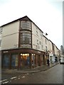
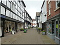
Photos of HR6 8AH


Area Information
HR6 8AH is a small, tightly knit residential postcode in England, home to 1452 people. It is a compact area where daily life is shaped by its modest scale and proximity to essential services. The community here is largely composed of adults aged 30–64, with a median age of 47, suggesting a stable, established population. The area’s character is defined by its mix of private homes, with 52% of properties owned by residents, and a predominance of family-oriented living. While it lacks the density of larger towns, HR6 8AH offers a quiet, manageable environment with access to local amenities and transport links. Its small size means residents are likely to know their neighbours, creating a sense of familiarity. For those seeking a balance between seclusion and practicality, this area provides a foundation for a settled lifestyle, though its limited scope may require consideration of nearby towns for broader opportunities.
- Area Type
- Postcode
- Area Size
- Not available
- Population
- 1452
- Population Density
- 3597 people/km²
The property market in HR6 8AH is characterised by a 52% home ownership rate, with houses forming the majority of accommodation types. This suggests a predominantly owner-occupied area, likely attracting families and individuals seeking long-term stability. The limited size of the postcode means the housing stock is relatively small, with properties concentrated in a compact cluster. Buyers should consider that the area’s immediate surroundings may hold more options, though the small scale of HR6 8AH itself could limit availability. The prevalence of houses over flats or apartments indicates a focus on traditional, family-friendly living. For those prioritising ownership, this area offers a manageable, low-density environment, though the narrow footprint may require exploring adjacent postcodes for additional choices.
House Prices in HR6 8AH
No properties found in this postcode.
Energy Efficiency in HR6 8AH
The lifestyle in HR6 8AH is shaped by its proximity to retail and transport hubs. Within practical reach are Co-op Leominster, Aldi Leominster, and Morrisons Leominster, offering a range of grocery and household essentials. These stores cater to daily needs, reducing the necessity for long trips to larger towns. The area is also served by Leominster Railway Station, enabling access to broader regional destinations. While parks and leisure facilities are not explicitly listed, the presence of retail and rail services suggests a functional, community-oriented lifestyle. The compact nature of the area means amenities are concentrated, fostering convenience but potentially limiting diversity in leisure options. For residents prioritising practicality over expansive recreational spaces, this postcode provides a straightforward, service-focused environment.
Amenities
Schools
Residents of HR6 8AH have access to a range of educational institutions, including Leominster Infants’ School and Leominster Junior School, both primary schools serving younger children. Westfield School, a special school, caters to specific educational needs, while Leominster Primary School, also a primary school, holds an Ofsted rating of ‘good’. This mix of school types ensures families have options for both mainstream and specialist education. The presence of multiple primary schools within proximity supports local families, reducing the need for long commutes. However, the absence of secondary schools in the immediate area may necessitate travel to nearby towns for older students. The combination of general and special needs provision reflects a commitment to inclusive education, though parents should verify transportation logistics for secondary schooling.
| Rank | School | Type | Entry gender | Ages |
|---|
Explore more schools in this area
Go to Schools tabDemographics
The population of HR6 8AH is 1452, with a median age of 47, reflecting a mature demographic skewed toward adults aged 30–64. This age group constitutes the most common cohort, indicating a community of working-age individuals and families. Home ownership stands at 52%, with houses being the primary accommodation type, suggesting a mix of long-term residents and those seeking stable housing. The predominant ethnic group is White, though specific data on diversity is not provided. The area’s demographic profile implies a low turnover of residents, with a focus on stability over transient living. While no deprivation data is available, the presence of a moderate population size and established housing stock suggests a community with reasonable access to services. However, the lack of detailed socioeconomic breakdowns means broader quality-of-life implications remain unquantified.
Household Size
Accommodation Type
Tenure
Ethnic Group
Religion
Household Composition
Age
Household Deprivation
NS-SEC
Explore more demographic insights in this area
Go to Demographics tabPlanning
Planning Constraints
- Flood RiskPremium
- Ramsar Wetland SitesPremium
- Area of Outstanding Natural BeautyPremium
- Protected Nature ReservePremium
- Protected WoodlandPremium