Area Overview for HR6 6AG
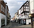
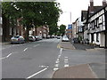
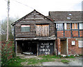
Photos of HR6 6AG


Area Information
Living in HR6 6AG means being part of a small, tightly knit residential cluster in England, home to 1,650 people. This area is characterised by its compact size and proximity to essential services, making it practical for daily life. The community is served by Leominster Railway Station, offering rail connections, while nearby retail options such as Co-op Leominster, Aldi Leominster, and Morrisons Leominster provide convenience for shopping. The area’s small scale means a quiet, localised feel, though it remains connected to broader networks. With a population that skews towards adults aged 30–64, HR6 6AG is a place where established residents predominate. While it lacks large-scale amenities, its simplicity and accessibility make it appealing for those seeking a straightforward, low-maintenance lifestyle. The absence of major planning constraints or environmental risks adds to its practicality, though buyers should consider the area’s limited scope and the need for a car for longer journeys. For those prioritising convenience and a slower pace, HR6 6AG offers a focused, community-oriented environment.
- Area Type
- Postcode
- Area Size
- Not available
- Population
- 1650
- Population Density
- 2757 people/km²
The property market in HR6 6AG is defined by its limited scale and focus on house ownership. With 32% of residents owning their homes, the area is not heavily dominated by rental properties, though the small population size means the market is constrained. The prevalence of houses over flats or apartments suggests a preference for traditional, standalone homes, which may appeal to buyers seeking space and privacy. However, the low home ownership rate implies that a significant proportion of properties are rented, potentially creating competition for available homes. For buyers, the area’s small size means that properties are likely to be in close proximity to one another, with limited scope for expansion. This makes HR6 6AG more suitable for those prioritising convenience and established infrastructure over investment potential. The market’s character is shaped by its residential focus, offering a straightforward, if unexciting, option for homebuyers.
House Prices in HR6 6AG
No properties found in this postcode.
Energy Efficiency in HR6 6AG
The lifestyle in HR6 6AG is shaped by its proximity to essential retail and transport hubs. Residents have access to four notable retail outlets, including Co-op Leominster, Aldi Leominster, and Morrisons Leominster, which provide a range of shopping options within practical reach. The Leominster Railway Station offers rail connectivity, facilitating travel to nearby destinations. While the area lacks large parks or leisure facilities, the availability of local shops and transport links contributes to a convenient, low-maintenance lifestyle. The compact nature of HR6 6AG means that daily errands and social interactions are likely to occur within a short radius, fostering a sense of community. For those who prioritise accessibility over expansive recreational spaces, the area’s amenities are sufficient, though additional leisure options may require venturing further afield.
Amenities
Schools
Residents of HR6 6AG have access to a range of educational institutions, including Earl Mortimer College, a primary school with a good Ofsted rating, and Cambian Hereford School, a special school also rated good. The presence of both a primary and special school suggests a mix of educational needs, though the absence of a secondary school may require families to look further afield. The Priory Pupil Referral Unit, an other-type school, indicates support for students with specific educational requirements. While the good ratings at Earl Mortimer College and Cambian Hereford School are reassuring, families should consider whether these schools align with their children’s needs, particularly if a secondary education is required. The limited variety of school types may necessitate additional travel for students, but the quality of the existing institutions provides a foundation for families seeking a stable educational environment.
| Rank | School | Type | Entry gender | Ages |
|---|
Explore more schools in this area
Go to Schools tabDemographics
The population of HR6 6AG has a median age of 47, with the majority of residents falling within the 30–64 age range. This suggests a community of established adults, many of whom may be in their prime working years or nearing retirement. Home ownership in the area is relatively low at 32%, indicating that a significant portion of the population rents their homes. The predominant accommodation type is houses, which aligns with the area’s small, residential nature. The ethnic composition is largely White, reflecting a homogenous demographic profile. While this data does not provide direct insight into deprivation levels, the low home ownership rate may hint at economic diversity, with some residents relying on rental income or other forms of financial support. The age distribution and housing stock suggest a stable, if modest, quality of life, with fewer young families or transient populations compared to larger urban areas.
Household Size
Accommodation Type
Tenure
Ethnic Group
Religion
Household Composition
Age
Household Deprivation
NS-SEC
Explore more demographic insights in this area
Go to Demographics tabPlanning
Planning Constraints
- Flood RiskPremium
- Ramsar Wetland SitesPremium
- Area of Outstanding Natural BeautyPremium
- Protected Nature ReservePremium
- Protected WoodlandPremium