Area Overview for HR4 9DA
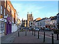
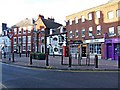
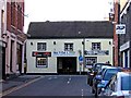
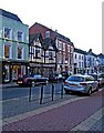
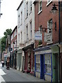
Photos of HR4 9DA


Area Information
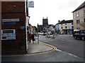
HR4 9DA is a compact residential postcode in England, covering just 346 square metres and home to 1832 residents. Its high population density—over 5.3 million people per square kilometre—reflects a tightly clustered community, likely centred around local amenities and transport links. The area is notable for its proximity to Hereford Railway Station, offering direct rail connections to nearby towns and cities. Daily life here is shaped by its small scale, with residents relying on nearby retail hubs like M&S Hereford, Tesco Hereford, and Sainsburys Hereford for essentials. The demographic profile suggests a mature population, with a median age of 47 and most residents aged between 30 and 64. While the area lacks natural constraints like protected woodlands or AONB designations, it faces a critical challenge: a high crime risk, with a safety score of 0/100. This underscores the need for residents to prioritise security measures. Despite these concerns, the area’s proximity to educational institutions and transport networks makes it a practical choice for those seeking convenience over expansive space.
- Area Type
- Postcode
- Area Size
- 346 m²
- Population
- 1832
- Population Density
- 1886 people/km²
The property market in HR4 9DA is characterised by low home ownership, with only 24% of residents owning their homes. This suggests a rental-dominated market, where flats are the primary accommodation type. The small area size and high population density indicate a limited housing stock, likely concentrated in multi-unit developments or older residential blocks. For buyers, this presents a challenge: the area’s compact nature means competition for available properties, particularly for those seeking owner-occupied homes. The prevalence of flats may appeal to those prioritising convenience over space, but it also limits options for larger families or those desiring private gardens. Given the high population density, property values may be influenced more by proximity to amenities like Hereford Railway Station and retail hubs than by traditional factors like land size. Prospective buyers should consider the area’s rental focus and assess whether the available housing meets their long-term needs.
House Prices in HR4 9DA
Showing 2 properties
| Address | Type | Beds | Baths | Last Sale Price | Last Sale Date | |
|---|---|---|---|---|---|---|
| Environmental Management Solutions, Environment Solutions, 22A King Street, Hereford, HR4 9DA | Office | - | - | - | - | |
| Ng Associates, Ng Associates Ltd, 22A King Street, Hereford, HR4 9DA | Office | - | - | - | - |
Energy Efficiency in HR4 9DA
Daily life in HR4 9DA is shaped by its proximity to essential amenities, including major retail outlets like M&S Hereford, Tesco Hereford, and Sainsburys Hereford, which provide shopping and dining options within easy reach. The Hereford Railway Station offers a key transport link, facilitating access to broader regional networks. While the area lacks expansive parks or leisure facilities, its compact nature ensures that services are closely clustered, reducing travel time for residents. The presence of multiple schools, including state and independent options, adds to the area’s appeal for families. However, the high population density may contribute to a more urbanised, less secluded lifestyle. The combination of retail, transport, and educational resources creates a functional environment, though the absence of green spaces or recreational facilities may be a drawback for those prioritising outdoor leisure.
Amenities
Schools
Residents of HR4 9DA have access to a range of educational institutions, including St Thomas Cantilupe CofE Primary School, which provides state-funded primary education. For independent schooling, Hereford Cathedral School and Hereford Cathedral Junior School cater to both primary and secondary levels, offering fee-paying alternatives. Additionally, the area is served by Herefordshire Pupil Referral Service and Herefordshire Pupil Referral Unit, which provide support for students with complex needs. This mix of school types offers families flexibility, whether they seek state education, independent schooling, or specialist support. However, the absence of Ofsted ratings or performance data means prospective families must rely on other indicators, such as proximity and school reputation, to make informed decisions. The presence of both mainstream and specialist institutions reflects the area’s commitment to addressing diverse educational needs, though the quality of these schools remains unquantified in the data.
| Rank | School | Type | Entry gender | Ages |
|---|
Explore more schools in this area
Go to Schools tabDemographics
The community in HR4 9DA is predominantly composed of adults aged 30 to 64, with a median age of 47. This suggests a settled population, likely focused on careers and family life. Home ownership is low, with only 24% of residents owning their homes, indicating a rental market that may cater to professionals or those seeking temporary housing. The accommodation type is largely flats, reflecting a compact living arrangement suited to the area’s small footprint. The predominant ethnic group is White, though specific diversity metrics are not provided. The high population density—5.3 million per square kilometre—raises questions about living conditions, though it also fosters a tightly knit community. For buyers, this demographic profile implies a market where demand for rental properties may outweigh supply, particularly for flats. However, the lack of data on deprivation levels means the area’s economic challenges remain unquantified.
Household Size
Accommodation Type
Tenure
Ethnic Group
Religion
Household Composition
Age
Household Deprivation
NS-SEC
Explore more demographic insights in this area
Go to Demographics tabPlanning
Planning Constraints
- Flood RiskPremium
- Ramsar Wetland SitesPremium
- Area of Outstanding Natural BeautyPremium
- Protected Nature ReservePremium
- Protected WoodlandPremium