Area Overview for HR4 9AS
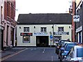
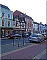
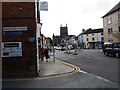
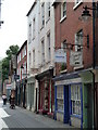
Photos of HR4 9AS


Area Information
Living in HR4 9AS means being part of a small, tightly knit residential cluster in England with a population of 1832. This area is characterised by its compact nature, where daily life revolves around local amenities and proximity to Hereford’s urban centre. The community is predominantly composed of adults aged 30-64, reflecting a mature demographic that may prioritise stability and established services. While the area’s size is modest, it offers access to key infrastructure such as retail hubs, a railway station, and a range of educational institutions. For those seeking a balance between urban convenience and a quieter residential environment, HR4 9AS provides a foothold in Herefordshire. However, its small scale means that the housing stock is limited, with flats being the primary accommodation type. This makes the area particularly suited to those looking for rental properties or smaller living spaces. The presence of independent schools nearby adds to its appeal for families, though the broader context of local services and connectivity should be considered when evaluating long-term suitability.
- Area Type
- Postcode
- Area Size
- Not available
- Population
- 1832
- Population Density
- 1886 people/km²
The property market in HR4 9AS is defined by its low home ownership rate of 24%, indicating that the majority of properties are rented rather than owned. The accommodation type is predominantly flats, which suggests a housing stock designed for smaller households or individuals seeking rental options. This makes the area more suited to tenants than buyers, particularly those looking for short-term or flexible living arrangements. The limited size of HR4 9AS means that the housing supply is constrained, which could impact availability and competition for properties. For buyers, the focus on flats may mean fewer opportunities for larger homes or family-sized properties. The area’s proximity to Hereford’s amenities and transport links could offset its smaller scale, but prospective buyers should consider the long-term viability of investing in a rental-heavy market with limited expansion potential.
House Prices in HR4 9AS
No properties found in this postcode.
Energy Efficiency in HR4 9AS
The lifestyle in HR4 9AS is supported by nearby amenities that cater to retail, dining, and transport needs. Within practical reach are major retailers such as M&S Hereford, Tesco Hereford, and Waitrose Hereford, offering a range of shopping options for daily necessities and groceries. The presence of Hereford Railway Station provides access to broader regional networks, facilitating travel to nearby towns and cities. While the area does not list specific parks or leisure facilities, its proximity to Hereford’s urban centre likely means residents can access larger recreational spaces, cultural venues, and dining options. The combination of retail outlets and transport links contributes to a convenient, though compact, lifestyle. However, the absence of detailed information on green spaces or leisure amenities means that those prioritising outdoor activities may need to explore beyond HR4 9AS.
Amenities
Schools
Residents of HR4 9AS have access to a mix of state and independent schools, though no Ofsted ratings are provided. St Thomas Cantilupe CofE Primary School serves the area as a state-funded primary institution, while Hereford Cathedral School and Hereford Cathedral Junior School are independent options. These schools cater to different educational preferences, with the independent institutions likely offering specialist curricula or smaller class sizes. The presence of Herefordshire Pupil Referral Service and Herefordshire Pupil Referral Unit suggests that the area may have a need for alternative education provisions, though these are not traditional schools. Families seeking a range of educational choices may find the combination of state and independent options useful, though the absence of detailed performance data means that school quality must be assessed through other means.
| Rank | School | Type | Entry gender | Ages |
|---|
Explore more schools in this area
Go to Schools tabDemographics
The population of HR4 9AS is 1832, with a median age of 47, indicating a community skewed towards middle-aged and older residents. The most common age range is 30-64 years, suggesting a stable, established demographic that may have strong ties to local institutions. Home ownership rates are low at 24%, implying that a significant proportion of residents are renters, which could reflect the area’s focus on rental flats rather than owner-occupied properties. The predominant accommodation type is flats, aligning with the lower home ownership figure and suggesting a housing stock tailored to smaller households or those preferring rental flexibility. The predominant ethnic group is White, though no specific data on diversity or deprivation is provided. This demographic profile may influence the character of local services and social dynamics, with a focus on community-centric amenities rather than a diverse, multi-generational mix.
Household Size
Accommodation Type
Tenure
Ethnic Group
Religion
Household Composition
Age
Household Deprivation
NS-SEC
Explore more demographic insights in this area
Go to Demographics tabPlanning
Planning Constraints
- Flood RiskPremium
- Ramsar Wetland SitesPremium
- Area of Outstanding Natural BeautyPremium
- Protected Nature ReservePremium
- Protected WoodlandPremium