Area Overview for GL20 6HT
Photos of GL20 6HT
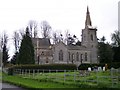


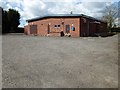
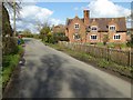

100 photos from this area
Area Information
Key information about the GL20 6HT including its size, population, and administrative classification.
- Area Type
- Postcode
- Area Size
- 76.7 hectares
- Population
- 2158
- Population Density
- 35 people/km²
House Prices in GL20 6HT
12
Properties
£488,000
Average Sold Price
£175,000
Lowest Price
£840,000
Highest Price
Showing 12 properties
| Address | Type | Beds | Baths | Last Sale Price | Last Sale Date | |
|---|---|---|---|---|---|---|
| Bonnetts End, Church End, Bushley, GL20 6HT | Semi-detached | 3 | 1 | £280,000 | Sep 2025 | |
| Wellingtonia House, Church End, Bushley, GL20 6HT | Detached | 7 | 2 | £840,000 | Dec 2020 | |
| Biddles Orchard, Church End, Bushley, GL20 6HT | Detached | 6 | 4 | £740,000 | Aug 2019 | |
| The Old School House, Church End, Bushley, GL20 6HT | Detached | 3 | - | £405,000 | Dec 2013 | |
| Tean, Church End, Bushley, GL20 6HT | Semi-detached | 2 | 1 | £175,000 | Apr 2001 | |
| Meadow View, Church End, Bushley, GL20 6HT | Detached | - | - | - | - | |
| Church Farm, Church End, Bushley, GL20 6HT | Detached | - | - | - | - | |
| Shepherds Peace, Church End, Bushley, GL20 6HT | Detached | - | - | - | - | |
| The Coach House Barn, Church End, Bushley, GL20 6HT | Detached | - | - | - | - | |
| The Apple Store At, Church Farm, Church End, Bushley, GL20 6HT | Semi-detached | 1 | - | - | - |
Page 1 of 2
Energy Efficiency in GL20 6HT
Amenities
Schools
| Rank | School | Type | Entry gender | Ages |
|---|
Explore more schools in this area
Go to Schools tabDemographics
Household Size
Two person
most common
Accommodation Type
Houses
most common
Tenure
80
majority
Ethnic Group
White
most common
Religion
N/A
most common
Household Composition
N/A
most common
Age
47
median
Adults (30-64 years)
most common
Household Deprivation
N/A
with no deprivation
NS-SEC
42
in Lower managerial occupations
Explore more demographic insights in this area
Go to Demographics tabPlanning
Planning Constraints
- Flood RiskPremium
- Ramsar Wetland SitesPremium
- Area of Outstanding Natural BeautyPremium
- Protected Nature ReservePremium
- Protected WoodlandPremium