Area Overview for DY9 9LG
Photos of DY9 9LG


Area Information
Living in DY9 9LG offers a compact, residential experience with a population of 1520 spread across 25.5 hectares. This small cluster is characterised by a mature demographic, with a median age of 47 and a majority of residents aged 30–64. The area’s low population density of 285 people per square kilometre ensures a quiet, community-focused environment. Daily life here is shaped by proximity to essential services, including five retail outlets such as Spar, Co-op Hagley, and Morrisons Daily, and easy access to rail networks like Hagley Railway Station and Stourbridge Junction. Families benefit from two primary schools—Hagley Primary School, rated good by Ofsted, and Hagley Middle School—both within practical reach. The area’s safety profile is strong, with a crime risk score of 77 (low) and no flood or environmental hazards. For those seeking a balanced blend of convenience, safety, and a settled community, DY9 9LG provides a straightforward, low-maintenance lifestyle.
- Area Type
- Postcode
- Area Size
- 25.5 hectares
- Population
- 1520
- Population Density
- 285 people/km²
The property market in DY9 9LG is dominated by owner-occupied homes, with 86% of residents living in houses rather than flats or other accommodation types. This suggests a market skewed towards family homes and long-term residency rather than rental properties. The small area size and limited housing stock mean the market is likely constrained, with properties potentially holding value due to their scarcity. Buyers should consider the proximity to schools, rail links, and retail amenities as key selling points. The predominance of houses over other property types indicates a demand for space and privacy, which may align with buyers seeking traditional, low-density living. However, the small size of the area means competition for properties could be fierce, and buyers may need to look beyond immediate surroundings for additional options.
House Prices in DY9 9LG
Showing 2 properties
| Address | Type | Beds | Baths | Last Sale Price | Last Sale Date | |
|---|---|---|---|---|---|---|
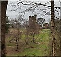
| The Flat, Hagley Hall, Hall Lane, Hagley, DY9 9LG | Flat | - | - | - | - | |
| Residence, Hagley Hall, Hall Lane, Hagley, DY9 9LG | Detached | - | - | - | - |
Energy Efficiency in DY9 9LG
The lifestyle in DY9 9LG is shaped by its proximity to essential amenities, including five retail outlets such as Spar, Co-op Hagley, and Morrisons Daily, which provide everyday shopping and dining options. The rail network, with stations like Hagley and Stourbridge Junction, ensures easy access to nearby towns and cities, supporting both social and professional needs. While the area lacks detailed information on parks or leisure facilities, the presence of schools and retail hubs suggests a focus on practicality over expansive recreational spaces. The community’s small size fosters a sense of familiarity, with residents likely forming close-knit relationships. The combination of accessible shops, reliable transport, and a safe environment contributes to a straightforward, low-maintenance lifestyle, ideal for those prioritising convenience and stability over large-scale amenities.
Amenities
Schools
Residents of DY9 9LG have access to two primary schools: Hagley Primary School, which holds a good Ofsted rating, and Hagley Middle School. Both institutions cater to the needs of local families, providing a range of educational options within a short distance. The presence of two primary schools suggests a focus on early education, though no secondary schools are listed in the data. For families prioritising academic quality, Hagley Primary School’s good rating offers reassurance. However, the absence of secondary education options within the area may require families to consider commuting to nearby towns for higher-level schooling. The proximity of these schools to residential properties enhances the area’s appeal for households with children, though the limited range of educational stages should be noted.
| Rank | School | Type | Entry gender | Ages |
|---|
Explore more schools in this area
Go to Schools tabDemographics
DY9 9LG is predominantly occupied by adults aged 30–64, reflecting a median age of 47. Home ownership is high, with 86% of residents living in owner-occupied properties, primarily houses. The area’s demographic is largely homogenous, with the White ethnic group forming the majority. This composition suggests a stable, long-term community with established social networks. The low population density and focus on owner-occupied housing indicate a preference for settled living over transient rental markets. While specific data on deprivation is absent, the combination of high home ownership and accessible amenities suggests a generally comfortable standard of living. The absence of significant diversity metrics implies a relatively uniform cultural and social landscape, which may appeal to those seeking a cohesive, familiar environment.
Household Size
Accommodation Type
Tenure
Ethnic Group
Religion
Household Composition
Age
Household Deprivation
NS-SEC
Explore more demographic insights in this area
Go to Demographics tabPlanning
Planning Constraints
- Flood RiskPremium
- Ramsar Wetland SitesPremium
- Area of Outstanding Natural BeautyPremium
- Protected Nature ReservePremium
- Protected WoodlandPremium