Area Overview for DY8 4JY
Photos of DY8 4JY

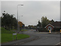
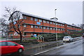
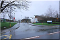
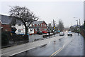
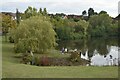
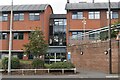
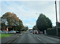
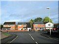
46 photos from this area
Area Information
Key information about the DY8 4JY including its size, population, and administrative classification.
- Area Type
- Postcode
- Area Size
- 8162 m²
- Population
- 2384
- Population Density
- 2871 people/km²
House Prices in DY8 4JY
26
Properties
£135,308
Average Sold Price
£42,500
Lowest Price
£215,000
Highest Price
Showing 26 properties
| Address | Type | Beds | Baths | Last Sale Price | Last Sale Date | |
|---|---|---|---|---|---|---|
| 19 Church Avenue, Amblecote, DY8 4JY | Semi-detached | 3 | 1 | £199,000 | Jan 2024 | |
| 7 Church Avenue, Amblecote, DY8 4JY | Semi-detached | 3 | 1 | £210,000 | Nov 2023 | |
| 23 Church Avenue, Amblecote, DY8 4JY | Semi-detached | 3 | 1 | £170,000 | Jan 2023 | |
| 22 Church Avenue, Amblecote, DY8 4JY | Semi-detached | 3 | 1 | £215,000 | Jan 2022 | |
| 12 Church Avenue, Amblecote, DY8 4JY | house | - | - | £181,000 | Aug 2021 | |
| 15 Church Avenue, Amblecote, DY8 4JY | Semi-detached | 3 | 1 | £125,000 | Aug 2014 | |
| 10 Church Avenue, Amblecote, DY8 4JY | Semi-detached | 3 | - | £122,000 | May 2014 | |
| 8 Church Avenue, Amblecote, DY8 4JY | Detached | 3 | 1 | £115,000 | Dec 2012 | |
| 9 Church Avenue, Amblecote, DY8 4JY | house | - | - | £110,250 | Sep 2012 | |
| 18 Church Avenue, Amblecote, DY8 4JY | Semi-detached | - | - | £74,950 | Apr 2003 |
Page 1 of 3
Energy Efficiency in DY8 4JY
Amenities
Schools
| Rank | School | Type | Entry gender | Ages |
|---|
Explore more schools in this area
Go to Schools tabDemographics
Household Size
One person
most common
Accommodation Type
Houses
most common
Tenure
71
majority
Ethnic Group
White
most common
Religion
N/A
most common
Household Composition
N/A
most common
Age
47
median
Adults (30-64 years)
most common
Household Deprivation
N/A
with no deprivation
NS-SEC
34
in Lower managerial occupations
Explore more demographic insights in this area
Go to Demographics tabPlanning
Planning Constraints
- Flood RiskPremium
- Ramsar Wetland SitesPremium
- Area of Outstanding Natural BeautyPremium
- Protected Nature ReservePremium
- Protected WoodlandPremium