Area Overview for DY5 2AE
Photos of DY5 2AE


Area Information
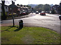
DY5 2AE is a compact residential postcode area in England, covering 599 square metres and home to 1,665 residents. Its high population density of 2.78 million people per square kilometre reflects its small, tightly clustered nature. This area is defined by its proximity to practical amenities, including retail outlets like Lidl, Iceland, and Asda, as well as multiple rail and metro stations. Daily life here is shaped by its accessibility to transport networks and local shops, making it convenient for those prioritising connectivity. The community is predominantly composed of adults aged 30–64, with a median age of 47, suggesting a mature, stable population. While the area lacks natural constraints such as protected woodlands or wetlands, its compact size means residents are close to essential services. For buyers, DY5 2AE offers a blend of practicality and proximity, though its small footprint means housing options are limited to a specific cluster of properties.
- Area Type
- Postcode
- Area Size
- 599 m²
- Population
- 1665
- Population Density
- 5331 people/km²
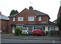
DY5 2AE is predominantly an owner-occupied area, with 62% of residents living in their own homes. The accommodation type is exclusively houses, which is unusual for a small postcode area but suggests a focus on family-sized properties. This configuration implies limited rental availability, making the market more attractive to buyers seeking long-term stability. However, the area’s compact size means housing stock is constrained, potentially limiting choices for buyers. The high population density, combined with a focus on single-family homes, may create a competitive market for properties, particularly for those prioritising space and privacy. For prospective buyers, the lack of flats or apartments means the area caters to those requiring traditional housing, though the small footprint could mean proximity to neighbours is a consideration.
House Prices in DY5 2AE
No properties found in this postcode.
Energy Efficiency in DY5 2AE
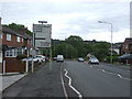
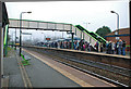
Living in DY5 2AE offers access to a range of practical amenities within short distances. Retail options include major supermarkets such as Lidl, Iceland, and Asda, ensuring daily shopping needs are met. The area’s transport links are extensive, with rail stations like Cradley Heath and Old Hill, as well as metro stops at Dartmouth Street and Lodge Road, providing connectivity to nearby hubs. While the data does not specify parks or leisure facilities, the presence of multiple retail and transport points suggests a focus on convenience over expansive recreational spaces. The compact nature of the area means residents can access essentials without long commutes, fostering a lifestyle centred on accessibility. The mix of retail and transport options supports a practical, efficient daily routine, though those prioritising green spaces may need to look beyond the immediate vicinity.
Amenities
Schools
| Rank | School | Type | Entry gender | Ages |
|---|
Explore more schools in this area
Go to Schools tabDemographics
The population of DY5 2AE skews towards adults aged 30–64, with a median age of 47. This suggests a community of established professionals and families, rather than students or retirees. Home ownership is strong, with 62% of residents owning their homes, and the predominant accommodation type is houses, indicating a more traditional residential profile. The area’s demographic is largely homogeneous, with the White ethnic group making up the majority. While no specific data on deprivation is provided, the high home ownership rate and mature age profile may correlate with lower levels of economic vulnerability. However, the area’s small size and high density could influence social dynamics, potentially fostering a close-knit community. The absence of detailed diversity metrics means the population’s full composition remains less defined, but the data underscores a stable, middle-aged demographic with a focus on homeownership.
Household Size
Accommodation Type
Tenure
Ethnic Group
Religion
Household Composition
Age
Household Deprivation
NS-SEC
Explore more demographic insights in this area
Go to Demographics tabPlanning
Planning Constraints
- Flood RiskPremium
- Ramsar Wetland SitesPremium
- Area of Outstanding Natural BeautyPremium
- Protected Nature ReservePremium
- Protected WoodlandPremium