Area Overview for DY5 1BE
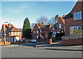
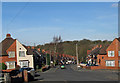
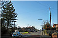
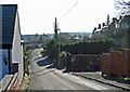
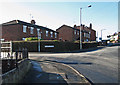
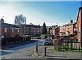
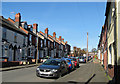
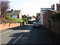
Photos of DY5 1BE
Area Information
DY5 1BE is a compact residential postcode area in England, covering just 1.6 hectares yet housing 1,531 people. This density translates to a population of nearly 97,000 per square kilometre, a stark contrast to the typical suburban sprawl. The area is defined by its small-scale cluster of homes, predominantly occupied by adults aged 30-64, with a median age of 47. Daily life here is shaped by proximity to essential services and transport links. While the footprint is limited, the area’s strategic location ensures residents have access to nearby retail, rail, and metro stations. The community feels tightly knit, with a focus on practical living rather than sprawling development. For those considering DY5 1BE, the key appeal lies in its balance of density and accessibility, though the small size means the housing stock is finite. It is a place where convenience and proximity to amenities outweigh the lack of expansive green spaces or sprawling infrastructure.
- Area Type
- Postcode
- Area Size
- 1.6 hectares
- Population
- 1531
- Population Density
- 5256 people/km²
The property market in DY5 1BE is characterised by a high rate of home ownership—67% of residents own their homes. This suggests a stable, long-term resident base with a preference for owning rather than renting. The accommodation type is predominantly houses, which are more common than flats or apartments in this small area. Given the limited size of DY5 1BE (1.6 hectares), the housing stock is finite, and the market is likely to be competitive for buyers. The concentration of houses may appeal to those seeking family-friendly properties or larger living spaces. However, the area’s small footprint means that the immediate surroundings are critical for additional housing options. For buyers, this implies that proximity to nearby postcode areas could be essential to expand choices. The lack of rental data means it is unclear whether the area is a buyer’s market or if renters are a significant presence.
House Prices in DY5 1BE
Showing 40 properties
| Address | Type | Beds | Baths | Last Sale Price | Last Sale Date | |
|---|---|---|---|---|---|---|
| 7 School Road, Quarry Bank, DY5 1BE | Semi-detached | 3 | 2 | £135,500 | Apr 2025 | |
| 25 School Road, Quarry Bank, DY5 1BE | house | 3 | 1 | £185,000 | Aug 2022 | |
| 12 School Road, Quarry Bank, DY5 1BE | Semi-detached | 3 | 1 | £183,000 | Jul 2022 | |
| 30 School Road, Quarry Bank, DY5 1BE | Semi-detached | 2 | 1 | £125,000 | Oct 2020 | |
| 6 School Road, Quarry Bank, DY5 1BE | Semi-detached | 2 | 2 | £122,500 | Jul 2019 | |
| 31 School Road, Quarry Bank, DY5 1BE | Semi-detached | 3 | 1 | £82,500 | Sep 2015 | |
| 19 School Road, Quarry Bank, DY5 1BE | Semi-detached | 4 | 1 | £73,000 | Apr 2015 | |
| 39 School Road, Quarry Bank, DY5 1BE | Detached | 3 | 2 | £87,000 | Jun 2009 | |
| 41 School Road, Quarry Bank, DY5 1BE | Semi-detached | - | - | £78,000 | Jun 2003 | |
| 24 School Road, Quarry Bank, DY5 1BE | Semi-detached | - | - | £67,000 | Dec 2002 |
Energy Efficiency in DY5 1BE
Living in DY5 1BE offers access to a range of practical amenities within walking or short driving distance. Retail options include Lidl Merry, Asda Dudley, and Iceland Merry, providing everyday grocery needs. The area’s transport network is extensive, with rail stations like Cradley Heath and Lye, as well as metro stops such as Lodge Road and Dudley Street Guns Village, ensuring easy access to public transport. While the data does not mention parks or leisure facilities, the presence of multiple retail and transport hubs suggests a focus on convenience over expansive recreational spaces. The compact nature of the area means residents are likely to rely on nearby towns for larger amenities. The combination of retail, transport, and proximity to urban centres creates a lifestyle that prioritises accessibility and practicality, though it may lack the green spaces or cultural venues found in larger towns.
Amenities
Schools
| Rank | School | Type | Entry gender | Ages |
|---|
Explore more schools in this area
Go to Schools tabDemographics
The community in DY5 1BE is predominantly composed of adults aged 30-64, with a median age of 47. This suggests a population skewed towards middle-aged individuals, likely including professionals and families. Home ownership is strong, with 67% of residents owning their homes, compared to the national average of around 65%. The accommodation type is primarily houses, indicating a mix of family homes and single-occupancy properties. The predominant ethnic group is White, though the data does not specify further diversity metrics. The high population density of 96,931 per square kilometre, despite the small area, implies a compact, possibly multi-generational living arrangement. While this density can foster community interaction, it also means limited space for expansion. The age profile suggests a stable, long-term resident base, though the absence of data on deprivation or income levels means the quality of life implications remain unquantified.
Household Size
Accommodation Type
Tenure
Ethnic Group
Religion
Household Composition
Age
Household Deprivation
NS-SEC
Explore more demographic insights in this area
Go to Demographics tabPlanning
Planning Constraints
- Flood RiskPremium
- Ramsar Wetland SitesPremium
- Area of Outstanding Natural BeautyPremium
- Protected Nature ReservePremium
- Protected WoodlandPremium