Area Overview for DY4 8HZ
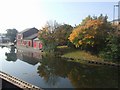
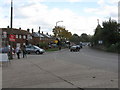
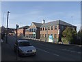
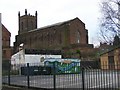
Photos of DY4 8HZ


Area Information
Living in DY4 8HZ means being part of a tightly knit residential cluster in England, where 1,868 people reside across 8,834 square metres. The area’s high population density of 211,454 people per square kilometre reflects its compact nature, ideal for those seeking a close-knit community. Despite its small size, DY4 8HZ offers practical access to essential amenities, including five rail stations such as Tipton and Dudley Port, and five metro stops like Bradley Lane. This connectivity supports both daily commutes and leisure travel. The area’s proximity to retail spots like Aldi Priory and Co-op Woodsetton ensures convenience for everyday needs. While the demographic data suggests a mature population, with a median age of 47, the presence of multiple transport hubs and low crime risk makes it appealing for families and professionals alike.
- Area Type
- Postcode
- Area Size
- 8834 m²
- Population
- 1868
- Population Density
- 7154 people/km²
The property market in DY4 8HZ is characterised by a 52% home ownership rate, with houses forming the primary accommodation type. This suggests a focus on family homes rather than high-density housing, which is typical of smaller residential clusters. Given the area’s compact size, the housing stock is likely limited, making it a niche market for buyers seeking properties in a low-crime, well-connected location. The predominance of owner-occupied homes indicates a stable community, though the relatively low home ownership rate also implies a significant rental market. Prospective buyers should consider the area’s small size and immediate surroundings, as property availability may be constrained by the postcode’s limited spatial extent.
House Prices in DY4 8HZ
Showing 35 properties
| Address | Type | Beds | Baths | Last Sale Price | Last Sale Date | |
|---|---|---|---|---|---|---|
| 16 Bell Street, Tipton, DY4 8HZ | Terraced | 2 | 1 | £176,000 | Sep 2025 | |
| 28 Bell Street, Tipton, DY4 8HZ | Semi-detached | 2 | 1 | £165,000 | Sep 2024 | |
| 12 Bell Street, Tipton, DY4 8HZ | Terraced | 4 | 1 | £160,000 | May 2024 | |
| 34 Bell Street, Tipton, DY4 8HZ | Terraced | 2 | 1 | £172,500 | Nov 2022 | |
| 19 Bell Street, Tipton, DY4 8HZ | Retail | 2 | 1 | £174,500 | Jul 2022 | |
| 18 Bell Street, Tipton, DY4 8HZ | Terraced | 2 | 1 | £90,000 | Jun 2019 | |
| 6 Bell Street, Tipton, DY4 8HZ | Terraced | 3 | 1 | £129,000 | Apr 2019 | |
| 11 Bell Street, Tipton, DY4 8HZ | Semi-detached | 3 | 2 | £144,950 | Oct 2018 | |
| 5 Bell Street, Tipton, DY4 8HZ | Semi-detached | 3 | 2 | £120,000 | Nov 2016 | |
| 30 Bell Street, Tipton, DY4 8HZ | house | - | - | £93,000 | Jan 2016 |
Energy Efficiency in DY4 8HZ
Daily life in DY4 8HZ is shaped by its proximity to essential amenities. Retail options include Aldi Priory and Co-op Woodsetton, offering grocery and convenience shopping within practical reach. The area’s rail and metro stations, such as Coseley and Wednesbury Parkway, provide frequent transport links to surrounding regions, supporting both work and social activities. While the data does not specify parks or leisure facilities, the absence of planning constraints like protected woodlands or AONB designations suggests open spaces may be available for recreation. The compact nature of the area ensures that residents can access shops, transport, and services without long commutes, fostering a convenient, community-focused lifestyle.
Amenities
Schools
| Rank | School | Type | Entry gender | Ages |
|---|
Explore more schools in this area
Go to Schools tabDemographics
DY4 8HZ has a median age of 47, with the majority of residents falling into the 30-64 age range. Home ownership stands at 52%, indicating a mix of owner-occupied properties and rental homes. The area is predominantly composed of houses, reflecting a traditional housing stock. The predominant ethnic group is White, which aligns with broader regional trends. The high population density of 211,454 people per square kilometre suggests a compact, possibly multi-generational living environment. While no specific deprivation data is provided, the low crime risk score of 73 suggests a relatively stable community. This combination of age demographics and housing types may appeal to professionals seeking established neighbourhoods with practical amenities.
Household Size
Accommodation Type
Tenure
Ethnic Group
Religion
Household Composition
Age
Household Deprivation
NS-SEC
Explore more demographic insights in this area
Go to Demographics tabPlanning
Planning Constraints
- Flood RiskPremium
- Ramsar Wetland SitesPremium
- Area of Outstanding Natural BeautyPremium
- Protected Nature ReservePremium
- Protected WoodlandPremium