Area Overview for DY4 8BF
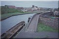
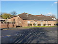
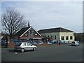
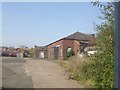
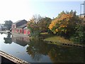
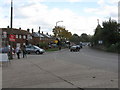
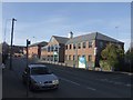
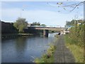
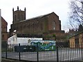
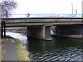
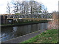
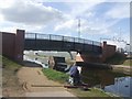
Photos of DY4 8BF
Area Information
DY4 8BF is a compact residential postcode in England, covering just 5,296 square metres and home to 1,772 people. Its high population density of 334,569 people per square kilometre reflects a tightly knit community, where proximity to amenities and services is a defining feature. The area is characterised by a mature demographic, with a median age of 47 and a majority of residents aged 30–64. This suggests a stable, established community with a focus on long-term living rather than transient populations. Daily life here is shaped by the proximity of essential services, including five nearby railway stations such as Tipton and Dudley Port, which provide easy access to regional transport networks. The area’s small size means residents are likely to know their neighbours, though the density may also mean a need for community-driven solutions to shared challenges. With broadband scores of 94 and mobile coverage of 85, connectivity is strong, supporting both remote work and digital lifestyles. While the area lacks natural constraints like protected woodlands or wetlands, its appeal lies in its practicality, accessibility, and the balance between urban convenience and residential tranquillity.
- Area Type
- Postcode
- Area Size
- 5296 m²
- Population
- 1772
- Population Density
- 3610 people/km²
DY4 8BF is a small area with a housing stock primarily composed of houses, as opposed to flats or apartments. The 54% home ownership rate indicates that nearly half of properties are owner-occupied, while the remaining 46% are likely rented. This mix suggests a balance between long-term residents and tenants, though the small size of the area may limit the variety of available properties. The predominance of houses could appeal to families or those seeking more space, but it may also mean fewer high-density housing options. Buyers should consider the area’s compact nature, which may restrict future development potential. The proximity to rail and metro stations, such as Dudley Port and Wednesbury Parkway, enhances the area’s appeal for commuters, though the high population density could impact property values. For those prioritising convenience over size, DY4 8BF offers a practical, if limited, selection of homes within reach of essential services.
House Prices in DY4 8BF
Showing 23 properties
| Address | Type | Beds | Baths | Last Sale Price | Last Sale Date | |
|---|---|---|---|---|---|---|
| 10, Rounds Wharf, Castle Street, Tipton, DY4 8BF | Terraced | 3 | 3 | £260,000 | May 2025 | |
| 23, Rounds Wharf, Castle Street, Tipton, DY4 8BF | house | - | - | £112,000 | Feb 2025 | |
| 3, Rounds Wharf, Castle Street, Tipton, DY4 8BF | Flat | - | - | £108,000 | Nov 2022 | |
| 8, Rounds Wharf, Castle Street, Tipton, DY4 8BF | house | - | - | £125,000 | Apr 2018 | |
| 9, Rounds Wharf, Castle Street, Tipton, DY4 8BF | house | - | - | £125,000 | Mar 2018 | |
| 22, Rounds Wharf, Castle Street, Tipton, DY4 8BF | Flat | - | - | £84,000 | Oct 2015 | |
| 4, Rounds Wharf, Castle Street, Tipton, DY4 8BF | Flat | - | - | £90,000 | Feb 2015 | |
| 6, Rounds Wharf, Castle Street, Tipton, DY4 8BF | Flat | - | - | £70,000 | Dec 2013 | |
| 7, Rounds Wharf, Castle Street, Tipton, DY4 8BF | Terraced | - | - | £192,000 | Nov 2008 | |
| 1, Rounds Wharf, Castle Street, Tipton, DY4 8BF | Flat | 3 | - | £134,950 | Feb 2008 |
Energy Efficiency in DY4 8BF
Living in DY4 8BF offers a blend of practicality and convenience, with essential amenities within reach. Retail options include Aldi Priory, Co-op Upper, and Tesco Dudley, providing grocery and daily shopping needs. The area’s proximity to five railway stations, such as Tipton and Dudley Port, and three metro stops—Bradley Lane, Loxdale, and Wednesbury Parkway—ensures easy access to public transport, supporting both local and regional travel. While the area lacks extensive green spaces or leisure facilities, its compact design minimises travel time to services. The presence of multiple retail and transport hubs suggests a community-oriented layout, where daily errands and commutes are efficiently managed. However, the high population density may mean shared spaces are in demand, requiring residents to balance convenience with potential limitations on private outdoor areas. For those prioritising accessibility over sprawling landscapes, DY4 8BF delivers a functional, if tightly packed, lifestyle.
Amenities
Schools
| Rank | School | Type | Entry gender | Ages |
|---|
Explore more schools in this area
Go to Schools tabDemographics
The population of DY4 8BF is predominantly adults aged 30–64, with a median age of 47. This suggests a community with a strong presence of middle-aged residents, likely including families and professionals settled in the area. Home ownership rates stand at 54%, indicating a mix of owner-occupied properties and rental units. The accommodation type is primarily houses, which may reflect a preference for family-friendly living spaces. The predominant ethnic group is White, with no data provided on other ethnicities. The high population density of 334,569 people per square kilometre, while unusual, suggests a compact, possibly multi-generational living environment. This density may influence local infrastructure demands, such as road capacity and public transport usage. The absence of specific data on deprivation levels means that quality of life factors like access to healthcare or leisure facilities remain unquantified, though the proximity of retail and transport hubs implies a baseline of convenience for residents.
Household Size
Accommodation Type
Tenure
Ethnic Group
Religion
Household Composition
Age
Household Deprivation
NS-SEC
Explore more demographic insights in this area
Go to Demographics tabPlanning
Planning Constraints
- Flood RiskPremium
- Ramsar Wetland SitesPremium
- Area of Outstanding Natural BeautyPremium
- Protected Nature ReservePremium
- Protected WoodlandPremium