Area Overview for DE13 8ZF
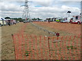
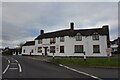
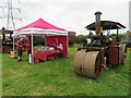
Photos of DE13 8ZF

Area Information
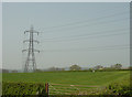
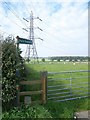
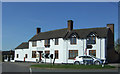
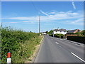
Living in DE13 8ZF means inhabiting a small, tightly knit residential cluster in England’s countryside. With a population of 1,591 and a density of 84 people per square kilometre, the area feels unpressured, offering a quiet alternative to urban sprawl. The community is predominantly composed of adults aged 30–64, many of whom own their homes—78% of properties are owner-occupied, reflecting a stable, long-term demographic. The area’s character is defined by its modest scale and proximity to local amenities, such as the Co-op stores in Barton-Under, Alrewas, and Branston. A rail link to Burton provides access to nearby towns, while the absence of major planning constraints or environmental restrictions ensures a straightforward living experience. Daily life here is low-key, with no significant flood or crime risks. For those seeking a balance between seclusion and practicality, DE13 8ZF offers a compact, functional base with minimal disruption.
- Area Type
- Postcode
- Area Size
- Not available
- Population
- 1591
- Population Density
- 84 people/km²
The property market in DE13 8ZF is dominated by owner-occupied homes, with 78% of properties in private hands. This suggests a market where long-term residency is the norm, rather than a transient rental scene. The accommodation type is primarily houses, which is typical for small rural clusters where space and privacy are prioritised. Given the area’s compact size, the housing stock is likely limited, meaning buyers may find fewer options compared to larger towns. The high home ownership rate also implies that properties are likely to hold value, though the absence of specific price data means it’s unclear whether this is a buyer’s or seller’s market. For those seeking a family home with minimal urban pressure, DE13 8ZF offers a straightforward, low-maintenance option. However, the small scale of the area may limit opportunities for investment or development.
House Prices in DE13 8ZF
No properties found in this postcode.
Energy Efficiency in DE13 8ZF
The lifestyle in DE13 8ZF is shaped by its proximity to local retail and transport hubs. Within practical reach are five retail outlets, including notable Co-op stores in Barton-Under, Alrewas, and Branston, offering everyday shopping convenience. These stores likely provide essentials such as groceries, household items, and local services, reducing the need for long trips to larger centres. The rail link to Burton adds accessibility to regional amenities, including leisure, healthcare, and employment opportunities. While the area lacks large-scale parks or entertainment venues, its small size and low population density suggest a peaceful, low-traffic environment. The combination of local shops and train access creates a self-contained lifestyle, ideal for those valuing simplicity and proximity to basic needs without the hustle of a larger town.
Amenities
Schools
The nearest school to DE13 8ZF is John Taylor High School, which operates both as a primary school and an academy with an Ofsted rating of outstanding. This dual designation suggests a single institution serving multiple age groups, which may be convenient for families with children at different stages of education. The academy status indicates a level of autonomy in curriculum and governance, potentially offering specialised teaching approaches. The outstanding rating from Ofsted reflects strong performance in areas such as pupil outcomes, staff quality, and resource availability. For families prioritising education, this school provides a reliable option, though the lack of additional schools in the area means there are no alternatives for those seeking different educational philosophies or settings.
| Rank | School | Type | Entry gender | Ages |
|---|---|---|---|---|
| 1 | John Taylor High School | primary | N/A | N/A |
| 2 | John Taylor High School | academy | N/A | N/A |
Explore more schools in this area
Go to Schools tabDemographics
DE13 8ZF’s population skews older, with a median age of 47 and the majority of residents falling within the 30–64 age bracket. This suggests a community of established professionals and families, with limited presence of younger or retired demographics. Home ownership is high at 78%, indicating a preference for long-term residency over rental properties. The accommodation type is predominantly houses, which aligns with the area’s low population density and rural character. The predominant ethnic group is White, reflecting a homogenous demographic profile. While no specific deprivation data is provided, the high home ownership rate and low crime score of 68 suggest a relatively stable quality of life. The absence of significant diversity metrics means the area’s social fabric is largely uniform, with no notable cultural or socioeconomic contrasts.
Household Size
Accommodation Type
Tenure
Ethnic Group
Religion
Household Composition
Age
Household Deprivation
NS-SEC
Explore more demographic insights in this area
Go to Demographics tabPlanning
Planning Constraints
- Flood RiskPremium
- Ramsar Wetland SitesPremium
- Area of Outstanding Natural BeautyPremium
- Protected Nature ReservePremium
- Protected WoodlandPremium
- Crime RiskPremium