Area Overview for CV9 2YZ
Photos of CV9 2YZ


Area Information
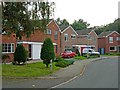
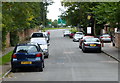
CV9 2YZ is a small residential cluster within the historic market town of Atherstone, north Warwickshire. With a population of 2,238 and a density of 1,544 people per square kilometre, it reflects a tight-knit community nestled along the A5, a route historically significant as the Roman Watling Street. The area retains much of its medieval layout, shaped by its Anglo-Saxon roots and Roman heritage nearby. Daily life here is characterised by proximity to amenities, including four railway stations within reach—Atherstone, Polesworth, Wilnecote, and Shenton—offering easy access to regional hubs. The area’s compact size means residents benefit from a mix of practical retail, like Tesco, Aldi, and Morrisons, alongside historical landmarks such as St Mary’s Chapel, a 12th-century site with listed status. Living in CV9 2YZ blends practicality with heritage, offering a quiet, stable environment for those seeking a balance between small-town charm and modern convenience.
- Area Type
- Postcode
- Area Size
- Not available
- Population
- 2238
- Population Density
- 1544 people/km²
The property market in CV9 2YZ is dominated by owner-occupied homes, with 75% of properties owned by residents rather than rented. The accommodation type is predominantly houses, reflecting a market that caters to families and individuals seeking more space and privacy. This contrasts with areas where flats or apartments dominate, suggesting a different dynamic in housing demand. Given the small size of the postcode area, the housing stock is likely limited, with properties concentrated in the historic core of Atherstone. Buyers should consider the proximity to amenities and the character of the homes, many of which may date back to the 19th or early 20th centuries. The high home ownership rate implies a stable market, though the limited number of properties may mean competition for available homes.
House Prices in CV9 2YZ
No properties found in this postcode.
Energy Efficiency in CV9 2YZ
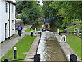
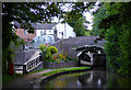
The lifestyle in CV9 2YZ is shaped by its proximity to practical amenities and historical character. Within reach are five retail outlets, including Tesco Atherstone, Aldi Atherstone, and Morrisons Daily, offering everyday shopping needs. The area’s historical legacy is evident in landmarks like St Mary’s Chapel, a 12th-century site with listed status, and the annual Shrove Tuesday Ball Game, a tradition dating to the early 12th century. Residents also enjoy the architectural heritage of Long Street, featuring Victorian and Georgian facades. The mix of modern retail and historic sites creates a unique environment where daily convenience meets cultural richness. For those who value both practicality and heritage, CV9 2YZ offers a well-rounded lifestyle.
Amenities
Schools
The nearest school to CV9 2YZ is Atherstone Nursery School, a nursery providing early education for young children. While no Ofsted rating is provided, the presence of a nursery indicates that families have access to foundational educational services within the area. The absence of primary or secondary schools in the immediate vicinity suggests that residents may need to travel to nearby towns for older children’s schooling. This mix of school types—limited to early years provision—means the area is well-suited for families with young children but may require additional planning for older students. Parents should consider the proximity of secondary schools in surrounding areas, such as those in Atherstone or nearby towns like Nuneaton.
| Rank | School | Type | Entry gender | Ages |
|---|
Explore more schools in this area
Go to Schools tabDemographics
The population of CV9 2YZ has a median age of 47, with the majority of residents aged between 30 and 64 years. This suggests a community skewed towards middle-aged adults, likely including families and professionals. Home ownership is high, at 75%, with the predominant accommodation type being houses rather than flats. The area’s demographic profile indicates a relatively stable, long-term resident base, with the White ethnic group forming the majority. The age distribution and ownership rates suggest a mature, established neighbourhood where properties are likely to be owned by long-term residents rather than transient renters. The absence of specific deprivation data means the quality of life here can be inferred from the low crime risk and limited environmental constraints, pointing to a generally secure and settled community.
Household Size
Accommodation Type
Tenure
Ethnic Group
Religion
Household Composition
Age
Household Deprivation
NS-SEC
Explore more demographic insights in this area
Go to Demographics tabPlanning
Planning Constraints
- Flood RiskPremium
- Ramsar Wetland SitesPremium
- Area of Outstanding Natural BeautyPremium
- Protected Nature ReservePremium
- Protected WoodlandPremium