Area Overview for CV9 1HT
Photos of CV9 1HT


Area Information
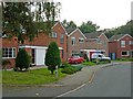
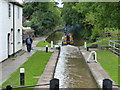
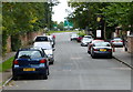
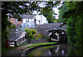
CV9 1HT is a small residential postcode in north Warwickshire, encompassing parts of the historic market town of Atherstone. With a population of 2,238 and a density of 1,544 people per square kilometre, this area reflects a compact, closely knit community. Atherstone itself lies along the ancient Roman Watling Street, now the A5, and retains traces of its Anglo-Saxon and medieval past. The town’s layout has remained largely unchanged due to limited redevelopment, preserving a mix of historic and more recent architecture. Daily life here is shaped by its proximity to local amenities, including multiple retail outlets and railway stations, while its low crime risk and flood safety scores make it an attractive option for those seeking a stable, secure environment. The area’s small size means residents are likely to know their neighbours, with a strong emphasis on community ties. For buyers, CV9 1HT offers a blend of practicality and historical character, ideal for those prioritising safety, convenience, and a sense of continuity with the past.
- Area Type
- Postcode
- Area Size
- Not available
- Population
- 2238
- Population Density
- 1544 people/km²
The property market in CV9 1HT is characterised by a high rate of home ownership (75%) and a predominance of houses over flats or apartments. This suggests a residential area where many properties are owner-occupied, likely reflecting the town’s semi-rural nature and the presence of larger homes. The limited size of the postcode means the housing stock is relatively small, with fewer options for buyers compared to larger urban areas. However, the availability of nearby railway stations, including Atherstone and Polesworth, may make the area attractive to commuters or those seeking a balance between suburban living and easy access to transport. For buyers, this small cluster of homes may offer a sense of exclusivity, though the limited supply could mean competition for available properties. The focus on houses also implies that the area is less suited to those seeking rental properties or smaller dwellings.
House Prices in CV9 1HT
No properties found in this postcode.
Energy Efficiency in CV9 1HT
Living in CV9 1HT offers access to a range of local amenities within easy reach. The area includes five retail outlets, such as Aldi Atherstone, Morrisons Daily, and Tesco Atherstone, providing essential shopping options. Nearby railway stations, including Atherstone and Polesworth, enhance connectivity, allowing residents to travel to larger towns for additional services. The historic character of Atherstone itself adds to the lifestyle, with its preserved streets and heritage sites contributing to a distinct sense of place. While the data does not mention parks or leisure facilities, the proximity to Atherstone’s historic railway station and its surrounding town centre likely offer opportunities for cultural or recreational activities. The combination of practical amenities and historical context creates a balanced environment for residents seeking both convenience and a connection to the past.
Amenities
Schools
The nearest school to CV9 1HT is Atherstone Nursery School, which provides early years education. No primary or secondary schools are listed in the data, meaning families may need to look beyond the immediate area for comprehensive schooling. The absence of higher-level educational institutions suggests that parents should investigate nearby towns such as Nuneaton or Coventry for secondary school options. For those prioritising nursery care, the proximity of Atherstone Nursery School offers convenience, though the lack of additional schools highlights a potential limitation for families requiring a full range of educational services. This underscores the importance of researching broader regional options when considering CV9 1HT as a long-term home.
| Rank | School | Type | Entry gender | Ages |
|---|---|---|---|---|
| 1 | Atherstone Nursery School | nursery | N/A | N/A |
Explore more schools in this area
Go to Schools tabDemographics
The population of CV9 1HT has a median age of 47, with the majority of residents falling within the 30-64 age range. This suggests a community dominated by working-age adults, many of whom may be established professionals or families. Home ownership is high at 75%, indicating a strong presence of long-term residents and a stable property market. The predominant accommodation type is houses, reflecting a suburban or semi-rural character rather than high-density living. The predominant ethnic group is White, though specific data on diversity or deprivation is not provided. The absence of detailed diversity metrics means the area’s social composition remains largely unexplored in the data. However, the low crime risk score of 77 (out of 100) implies a generally safe environment, which may contribute to the area’s appeal for families and retirees.
Household Size
Accommodation Type
Tenure
Ethnic Group
Religion
Household Composition
Age
Household Deprivation
NS-SEC
Explore more demographic insights in this area
Go to Demographics tabPlanning
Planning Constraints
- Flood RiskPremium
- Ramsar Wetland SitesPremium
- Area of Outstanding Natural BeautyPremium
- Protected Nature ReservePremium
- Protected WoodlandPremium
- Crime RiskPremium