Area Overview for CV8 3TA
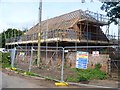
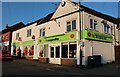
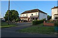
Photos of CV8 3TA
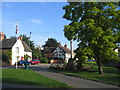
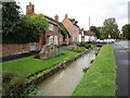
![Main Street cottages [1] in CV8 3TA](https://images.propbar.co.uk/images/geograph/57/76/5776261_120.jpg)
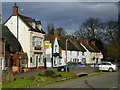
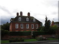
![Main Street cottages [2] in CV8 3TA](https://images.propbar.co.uk/images/geograph/57/76/5776275_120.jpg)
Area Information
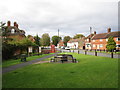
CV8 3TA is a small residential postcode area nestled in the village of Wolston, Warwickshire, midway between Rugby and Coventry. With a population of 1,648 and a density of 151 people per square kilometre, it reflects a compact, close-knit community. Wolston itself, home to 2,692 people according to the 2021 census, has historical roots dating back to the Domesday Book and features landmarks like Wolston Priory, a Scheduled Ancient Monument. The area is defined by its rural character, with the River Avon flowing nearby and proximity to the A45 road. Daily life here balances traditional village charm with modern convenience, offering access to local amenities, schools, and transport links. Residents benefit from a mix of historic and contemporary infrastructure, including a primary school, two pubs, and a small library. The village’s layout, with its historic earthworks and 19th-century railway viaduct, underscores its layered past while its current infrastructure supports a practical, low-maintenance lifestyle.
- Area Type
- Postcode
- Area Size
- Not available
- Population
- 1648
- Population Density
- 151 people/km²
The property market in CV8 3TA is characterised by high home ownership (69%) and a predominance of houses over flats or apartments. This suggests a market skewed towards owner-occupied properties, likely catering to families and long-term residents rather than short-term renters. The focus on houses, as opposed to other accommodation types, implies a demand for larger, more traditional homes, which may be more prevalent in a rural setting. Given the area’s small size and limited housing stock, buyers should consider nearby areas for additional options. The high home ownership rate also indicates a stable market with fewer rental properties, which could affect availability for those seeking to rent. For buyers, this environment may offer a sense of security and permanence, though competition for existing properties could be strong.
House Prices in CV8 3TA
No properties found in this postcode.
Energy Efficiency in CV8 3TA
The lifestyle in CV8 3TA is shaped by its accessible amenities, which include five retail outlets such as Co-op Wolston and M&S Binley Coventry. These shops provide convenience for daily errands, while the nearby Rugby Railway Station offers regional transport links. The area’s rural character is complemented by local pubs, the parish church of St Margaret’s, and a small library, fostering a community-oriented atmosphere. The presence of two pubs, The Rose & Crown and The Half Moon, adds to the village’s social fabric. For leisure, the River Avon and historic sites like Wolston Priory offer opportunities for walking or historical exploration. The blend of practical retail options and traditional village facilities supports a balanced lifestyle, combining modern convenience with a sense of place.
Amenities
Schools
Residents of CV8 3TA have access to two schools within practical reach. Wolston High School is a primary school, providing education for younger children. The Haven School in Wolston is a special school with a good Ofsted rating, offering tailored support for students with specific needs. This combination of school types ensures families have options for both general and specialist education. The presence of a special school with a positive rating highlights the area’s commitment to inclusive education, which can be a significant factor for parents. While no secondary schools are listed, the proximity to Wolston’s primary school and the availability of a special school suggest a well-rounded educational infrastructure for younger children.
| Rank | School | Type | Entry gender | Ages |
|---|
Explore more schools in this area
Go to Schools tabDemographics
The population of CV8 3TA has a median age of 47, with the majority of residents falling within the 30–64 age range. This suggests a community skewed towards adults, likely including families and professionals. Home ownership is high, at 69%, indicating a stable, long-term resident base. The area is predominantly composed of houses rather than flats or apartments, which aligns with the typical housing stock of rural villages. The predominant ethnic group is White, reflecting the broader demographic patterns of the region. The absence of specific data on deprivation or diversity means the area’s social composition remains largely defined by these parameters. The age profile and home ownership rate suggest a mature, established community with limited turnover, which can influence local services and amenities.
Household Size
Accommodation Type
Tenure
Ethnic Group
Religion
Household Composition
Age
Household Deprivation
NS-SEC
Explore more demographic insights in this area
Go to Demographics tabPlanning
Planning Constraints
- Flood RiskPremium
- Ramsar Wetland SitesPremium
- Area of Outstanding Natural BeautyPremium
- Protected Nature ReservePremium
- Protected WoodlandPremium