Area Overview for CV8 3ND
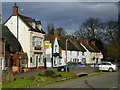
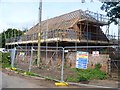
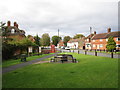
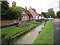
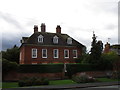
Photos of CV8 3ND
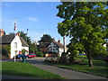
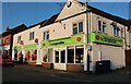
![Main Street cottages [1] in CV8 3ND](https://images.propbar.co.uk/images/geograph/57/76/5776261_120.jpg)
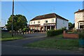
![Main Street cottages [2] in CV8 3ND](https://images.propbar.co.uk/images/geograph/57/76/5776275_120.jpg)
Area Information
CV8 3ND is a small residential cluster in the village of Wolston, Warwickshire, nestled between Rugby and Coventry. With a population of 1,724 and a density of 170 people per square kilometre, it retains a village feel despite its proximity to urban centres. The area is historically significant, with Wolston Priory’s earthwork remains designated as a Scheduled Ancient Monument. Residents benefit from proximity to the A45 road and the River Avon, which flows through the parish. Daily life here blends rural tranquillity with practical access to nearby towns. The village includes amenities like a primary school, two pubs, a library, and a pharmacy, fostering a close-knit community. While small, the area is well-connected to Coventry Airport and major transport routes, offering convenience for commuters. Its character is defined by historic architecture, such as the 1830s railway viaduct, and a mix of traditional and modern living. For buyers seeking a low-density, historically rich environment with easy access to services, CV8 3ND presents a distinct alternative to larger urban areas.
- Area Type
- Postcode
- Area Size
- Not available
- Population
- 1724
- Population Density
- 170 people/km²
The property market in CV8 3ND is characterised by high home ownership (83%) and a focus on houses rather than flats or apartments. This reflects a residential area where long-term occupancy is the norm, with limited rental activity. The small size of the postcode area means the housing stock is constrained, likely comprising semi-detached or detached homes typical of rural villages. Buyers should consider that the market is not geared toward investors seeking turnover, but rather toward those prioritising ownership in a low-density, historic setting. Proximity to Coventry and Rugby may offer opportunities for commuters, though the area’s small size limits extensive property choice. For those seeking a home with character and a connection to local heritage, CV8 3ND’s housing stock aligns with these priorities.
House Prices in CV8 3ND
No properties found in this postcode.
Energy Efficiency in CV8 3ND
Daily life in CV8 3ND is enriched by a mix of local amenities and nearby services. Within the area, residents can access two pubs—the Rose & Crown and The Half Moon—alongside a small library, convenience store, pharmacy, and doctors’ surgery. Retail options include Co-op Wolston, M&S Binley Coventry SF, and Asda Living, offering practical shopping for groceries and essentials. The village’s historic character is complemented by its community-focused facilities, such as the parish church of St Margaret’s and Wolston Baptist Church. While the area lacks large-scale leisure venues, its proximity to the River Avon and nearby towns provides opportunities for outdoor activities and cultural experiences. The combination of local pubs, shops, and healthcare services fosters a self-sufficient, neighbourly atmosphere.
Amenities
Schools
The nearest school to CV8 3ND is Wolston St Margaret’s CofE Primary School, which serves the local community with a ‘good’ Ofsted rating. As a primary school, it caters to children aged 4–11, providing foundational education within walking distance for many residents. The absence of secondary schools in the data means families may need to look to nearby towns for further education. However, the presence of a well-rated primary school supports the area’s appeal for families with young children, offering a stable educational environment. The school’s rating indicates a satisfactory standard of teaching and facilities, though parents may still seek additional resources or extracurricular options beyond the primary level.
| Rank | School | Type | Entry gender | Ages |
|---|
Explore more schools in this area
Go to Schools tabDemographics
The population of CV8 3ND is predominantly adults aged 30–64, with a median age of 47. This suggests a mature, stable community with a strong presence of working-age residents. Home ownership is high at 83%, indicating a preference for long-term residency over rental properties. The area is primarily composed of houses, reflecting a lack of high-density housing. The predominant ethnic group is White, with no data provided on other demographics. The absence of specific deprivation statistics means no direct conclusions can be drawn about economic hardship, but the high home ownership rate and age profile suggest a relatively affluent, settled population. The community’s structure—centred on family homes and local amenities—supports a lifestyle prioritising stability over transient living.
Household Size
Accommodation Type
Tenure
Ethnic Group
Religion
Household Composition
Age
Household Deprivation
NS-SEC
Explore more demographic insights in this area
Go to Demographics tabPlanning
Planning Constraints
- Flood RiskPremium
- Ramsar Wetland SitesPremium
- Area of Outstanding Natural BeautyPremium
- Protected Nature ReservePremium
- Protected WoodlandPremium