Area Overview for CV7 9QA
Photos of CV7 9QA


Area Information
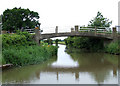
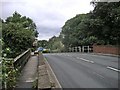
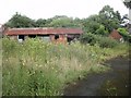
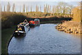
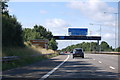
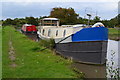
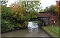
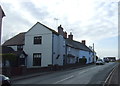
CV7 9QA is a small residential postcode nestled in the rural heart of Warwickshire, just 5 miles northeast of Coventry city centre. With a population of 1,564 and a low density of 45 people per square kilometre, it retains a village character despite its proximity to urban infrastructure. The area is defined by the B4065 road and the Oxford Canal, with the M6/M69/A46 junction within a mile. Historically a weaving and ribbon-making hub, Ansty today blends heritage with modern amenities. Its canal-side setting offers a tranquil escape, though boating is restricted by "no mooring" signs. The village’s charm lies in its quiet countryside vibe, complemented by nearby industrial sites like the London Electric Vehicle Company’s plant and the former Rolls-Royce engineering works. Residents enjoy a mix of rural seclusion and easy access to Coventry’s services, making it ideal for commuters or those seeking a slower pace of life.
- Area Type
- Postcode
- Area Size
- Not available
- Population
- 1564
- Population Density
- 45 people/km²
CV7 9QA is predominantly an owner-occupied area, with 86% of homes owned by residents rather than rented. The accommodation type is exclusively houses, indicating a focus on family homes and single-family dwellings. This contrasts with areas dominated by rental properties or mixed-use developments. Given the small population and low density, the housing stock is likely limited, with fewer properties available compared to larger towns. The high home ownership rate suggests long-term residency and a stable market, though buyers should consider the area’s size and proximity to Coventry for employment opportunities. The lack of flats or apartments may appeal to those seeking traditional, spacious housing but could limit options for first-time buyers or investors seeking alternative property types.
House Prices in CV7 9QA
No properties found in this postcode.
Energy Efficiency in CV7 9QA
CV7 9QA offers a blend of rural tranquillity and practical amenities. Nearby retail options include Tesco Coventry, Aldi Walsgrave, and Asda Coventry, accessible within a short drive. The Oxford Canal runs through the area, providing a leisure resource, though boating is restricted by local regulations. The village features a gastropub, golf club, and Ansty Hall, a Grade II listed Georgian mansion now operating as a hotel. These venues cater to both casual recreation and cultural interests. The presence of multiple railway stations and proximity to the M6 junction ensure connectivity to larger towns like Coventry and Hinckley. While the area’s small size means limited on-site amenities, its rural character and access to nearby services create a balanced lifestyle for residents.
Amenities
Schools
The nearest school to CV7 9QA is Shilton and Ansty CofE First School, a primary institution serving the local community. No secondary schools are listed in the data, meaning families may need to look beyond the immediate area for secondary education. The presence of a primary school indicates that the area is suitable for young families, though the absence of higher-level schooling could be a consideration for those planning long-term residency. The school’s type and Ofsted rating are not specified, so prospective parents may need to conduct further research or consult local education authorities for detailed performance metrics.
| Rank | School | Type | Entry gender | Ages |
|---|
Explore more schools in this area
Go to Schools tabDemographics
The population of CV7 9QA is predominantly middle-aged, with a median age of 47 and the majority of residents falling within the 30-64 age range. Home ownership is high at 86%, reflecting a stable, long-term community. The area is largely composed of houses, with no data indicating the presence of flats or other accommodation types. The predominant ethnic group is White, though specific diversity statistics are not provided. The low population density of 45 people per square kilometre suggests spacious living conditions. The age profile indicates a mature demographic, which may influence local services and amenities. With no mention of deprivation data, the area appears to support a quality of life aligned with its rural setting and stable housing market.
Household Size
Accommodation Type
Tenure
Ethnic Group
Religion
Household Composition
Age
Household Deprivation
NS-SEC
Explore more demographic insights in this area
Go to Demographics tabPlanning
Planning Constraints
- Flood RiskPremium
- Ramsar Wetland SitesPremium
- Area of Outstanding Natural BeautyPremium
- Protected Nature ReservePremium
- Protected WoodlandPremium