Area Overview for CV7 7SR
Photos of CV7 7SR
Area Information
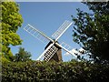
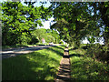
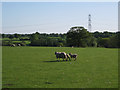
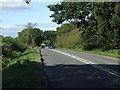
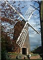
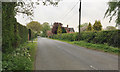
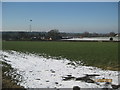
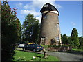
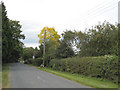
CV7 7SR represents a specific rural parish within Solihull, characterised by its distinct residential cluster and historic roots. This postcode covers an area of 13.4 hectares, housing a population of 1,420 residents. The location sits approximately 8 kilometres west of Coventry and 5 miles northwest of Kenilworth, marking it as a significant gateway between these urban centres. Historically part of Hampton-in-Arden until 1863, the parish was later enlarged in 1932 when land from Knowle was incorporated. Today, the area functions as a tranquil settlement defined by its junction of the A452 and B4101 roads. The community retains strong historical ties, evidenced by landmarks such as St. Mary's Church, which dates back to the 12th century, and Berkswell Windmill, a tower mill built in 1826. Living in this postcode means residing in a space where modern connectivity meets centuries-old heritage, offering a calm environment just outside the major conurbations of the West Midlands.
- Area Type
- Postcode
- Area Size
- 13.4 hectares
- Population
- 1420
- Population Density
- 804 people/km²
The property landscape in CV7 7SR reflects a stable, owner-occupied market typical of established rural parishes. With 81% of residents owning their homes, the area is clearly weighted towards individuals who have invested in property ownership over time. The vast majority of stock comprises houses, aligning with the area's classification as a civil parish rather than a suburban housing estate. You are unlikely to find new developments or high-rise apartments in this specific postcode, which covers only 13.4 hectares. This concentration of established housing suggests a market focused on repossessing existing stock or purchasing into mature properties. For buyers exploring homes in this vicinity, the environment is defined by a lack of large-scale new builds. The surrounding neighbourhoods, including the larger village of Balsall Common located nearby, share similar characteristics, reinforcing the region's identity as a place where people put down roots. The 1420 population within this specific cluster indicates a limited, selective market where properties command attention from those seeking a traditional house in a quiet setting.
House Prices in CV7 7SR
Showing 44 properties
| Address | Type | Beds | Baths | Last Sale Price | Last Sale Date | |
|---|---|---|---|---|---|---|
| 39, Albany Meadows, Albany Lane, Balsall Common, Solihull, CV7 7SR | Flat | - | - | £375,000 | Sep 2025 | |
| 41, Albany Meadows, Albany Lane, Balsall Common, Solihull, CV7 7SR | Flat | - | - | £410,000 | Jul 2024 | |
| 32, Albany Meadows, Albany Lane, Balsall Common, Solihull, CV7 7SR | Flat | - | - | £375,000 | Aug 2023 | |
| 7, Albany Meadows, Albany Lane, Balsall Common, Solihull, CV7 7SR | Semi-detached | 3 | 2 | £425,000 | Dec 2022 | |
| 30, Albany Meadows, Albany Lane, Balsall Common, Solihull, CV7 7SR | Flat | 2 | 2 | £394,000 | Jun 2022 | |
| 26, Albany Meadows, Albany Lane, Balsall Common, Solihull, CV7 7SR | Retail | 3 | 2 | £510,000 | May 2022 | |
| 38, Albany Meadows, Albany Lane, Balsall Common, Solihull, CV7 7SR | Flat | - | - | £387,500 | Mar 2022 | |
| 37, Albany Meadows, Albany Lane, Balsall Common, Solihull, CV7 7SR | Flat | - | - | £375,000 | Dec 2021 | |
| 17, Albany Meadows, Albany Lane, Balsall Common, Solihull, CV7 7SR | Flat | - | - | £400,250 | Dec 2021 | |
| 28, Albany Meadows, Albany Lane, Balsall Common, Solihull, CV7 7SR | Flat | - | - | £377,000 | Nov 2021 |
Energy Efficiency in CV7 7SR
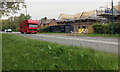
Daily life in CV7 7SR offers convenient access to quality retail and rail services without leaving the local region. Residents have immediate access to several notable supermarkets, including Heart of England Co-operative Co, Waitrose Little, and Tesco Common within easy reach. These venues cater to everyday shopping needs alongside premium grocery options. For commuters, the area benefits from a dense network of railway stations. Berkswell Railway Station, Tile Hill Railway Station, and Kenilworth Railway Station provide frequent services, while Birmingham International Railway Station serves major intercity connections. Transport options include five notable rail stations and five retail outlets within practical walking or short driving distance. The lifestyle is further enriched by the parish's historic character, anchored by landmarks like the 12th-century St. Mary's Church and the Berkswell Windmill, built in 1826. Living in this postcode allows you to enjoy the convenience of major retailers and rail hubs while maintaining the quiet atmosphere of a civil parish in the West Midlands.
Amenities
Schools
| Rank | School | Type | Entry gender | Ages |
|---|
Explore more schools in this area
Go to Schools tabDemographics
The community within CV7 7SR is defined by a mature resident base, with a median age of 47 years. Adults aged between 30 and 64 years constitute the most common age range in the area. This demographic profile suggests a settled population likely prioritising stability and community engagement. Home ownership stands at a high level, with 81% of residents owning their dwellings. This indicates a long-term commitment to the location rather than a transient rental market. The accommodation type is predominantly houses, reflecting the rural parish nature of the settlement rather than high-density urban living arrangements. White residents form the predominant ethnic group in this specific cluster of 1,420 people. The area exhibits a population density of 804 people per square kilometre, which classifies it as moderately dense for a rural setting outside the immediate city centres. You are likely to encounter a neighbourhood where long-term ownership and a consistent age profile create a predictable and steady living environment.
Household Size
Accommodation Type
Tenure
Ethnic Group
Religion
Household Composition
Age
Household Deprivation
NS-SEC
Explore more demographic insights in this area
Go to Demographics tabPlanning
Planning Constraints
- Flood RiskPremium
- Ramsar Wetland SitesPremium
- Area of Outstanding Natural BeautyPremium
- Protected Nature ReservePremium
- Protected WoodlandPremium