Area Overview for CV6 6FY
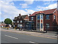
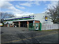
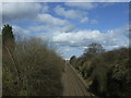
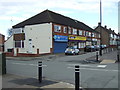
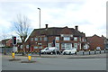
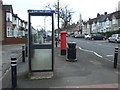
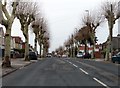
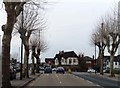
Photos of CV6 6FY


Area Information
CV6 6FY is a small residential cluster in the West Midlands, part of the Holbrooks suburb of Coventry. With a population of 2,318, it is a compact, suburban area defined by its compact housing developed from former green fields. Located approximately 3 miles north-west of Coventry’s city centre, the area is shaped by historical features such as culverted brooks and industrial heritage, including former coal mining and manufacturing sites. Daily life here is characterised by a mix of practicality and local history, with residents benefiting from proximity to amenities like Morrisons, Tesco, and nearby railway stations. The area’s layout, with its lanes and roads like Lythalls Lane and Parkgate Road, reflects its 19th-century origins, while modern infrastructure ensures connectivity. Living in CV6 6FY offers a blend of suburban tranquillity and access to Coventry’s urban resources, making it appealing for those seeking a balance between community and convenience.
- Area Type
- Postcode
- Area Size
- Not available
- Population
- 2318
- Population Density
- 3157 people/km²
The property market in CV6 6FY is dominated by owner-occupied homes, with 56% of properties owned by residents. The accommodation type is primarily houses, reflecting a suburban layout rather than high-density development. This suggests a market skewed towards family homes and long-term residents, with limited rental availability. The small area’s housing stock is likely to be characterised by older, traditional properties, given the area’s 19th- and 20th-century origins. For buyers, this means a focus on individual houses rather than apartments, with potential for property value stability due to the area’s established nature. However, the limited size of the postcode area may restrict options, requiring buyers to consider nearby suburbs or Coventry itself for broader choices.
House Prices in CV6 6FY
No properties found in this postcode.
Energy Efficiency in CV6 6FY
Living in CV6 6FY offers access to a range of amenities within practical reach. Retail options include Morrisons Whitmore, Morrisons Daily, and Tesco Coventry, providing everyday shopping convenience. The area’s proximity to railway stations like Coventry Arena and Bedworth ensures easy access to public transport, while the nearby Coventry Airport (listed twice in the data) adds to regional connectivity. Historically, the area’s brooks and industrial heritage contribute to its character, though modern life is shaped by practical amenities. The presence of schools such as Parkgate School and John Shelton School supports families, while local landmarks like Holbrooks Library offer community resources. The blend of retail, transport, and historical features creates a lifestyle that balances suburban comfort with urban accessibility.
Amenities
Schools
| Rank | School | Type | Entry gender | Ages |
|---|
Explore more schools in this area
Go to Schools tabDemographics
The community in CV6 6FY is predominantly middle-aged, with a median age of 47 and the most common age range being adults aged 30–64. Home ownership stands at 56%, indicating a mix of owner-occupied and rental properties. The area is primarily composed of houses rather than flats, reflecting a traditional suburban housing stock. The predominant ethnic group is White, though specific data on diversity is not provided. The age profile suggests a stable, established population, likely with families and long-term residents. This demographic structure influences the area’s character, with a focus on community continuity and practical living. The absence of detailed data on deprivation means the quality of life cannot be fully contextualised, but the age and ownership figures suggest a relatively settled, low-turnover neighbourhood.
Household Size
Accommodation Type
Tenure
Ethnic Group
Religion
Household Composition
Age
Household Deprivation
NS-SEC
Explore more demographic insights in this area
Go to Demographics tabPlanning
Planning Constraints
- Flood RiskPremium
- Ramsar Wetland SitesPremium
- Area of Outstanding Natural BeautyPremium
- Protected Nature ReservePremium
- Protected WoodlandPremium