Area Overview for CV6 3GB
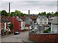
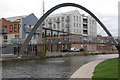
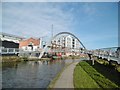
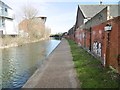
Photos of CV6 3GB

Area Information
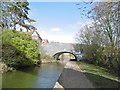
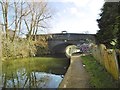
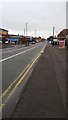
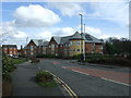
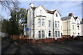
CV6 3GB is a small residential postcode in Coventry, part of the West Midlands, encompassing the Radford suburb. With a population of 1,841, it is a compact area defined by its suburban character and historical ties to the motor industry. Radford’s transformation from rural land to a manufacturing hub in the late 19th century shaped its identity, with the former Daimler and Jaguar factories once dominating the landscape. Today, the area is predominantly residential, featuring a mix of semi-detached, terraced, and flat properties. Its proximity to Coventry city centre—just 1.5 miles away—offers easy access to urban amenities while retaining a quieter, community-focused vibe. The war memorial, unveiled in 1919, stands as a local landmark, reflecting the area’s historical significance. Residents benefit from nearby rail links, retail outlets, and the Coventry Canal, which adds a touch of green space to daily life. The area’s blend of heritage and practicality makes it a distinct choice for those seeking a balance between suburban tranquillity and city connectivity.
- Area Type
- Postcode
- Area Size
- Not available
- Population
- 1841
- Population Density
- 8519 people/km²
The property market in CV6 3GB is characterised by a 41% home ownership rate, with houses being the predominant accommodation type. This suggests a mix of owner-occupied and rental properties, though the exact balance between the two is not specified. The area’s housing stock includes semi-detached and terraced homes, many of which date back to the 20th century. The prevalence of former council housing, now managed by private providers, indicates a legacy of social housing that has gradually transitioned into the private market. For buyers, this small area offers a limited but distinct selection of properties, with potential for character homes or family-oriented housing. The compact nature of the postcode means that immediate surroundings are likely to include similar housing types, making it a niche market for those seeking specific architectural styles or historical features. The lower home ownership rate may also imply greater availability of rental properties, though this is not explicitly confirmed by the data.
House Prices in CV6 3GB
No properties found in this postcode.
Energy Efficiency in CV6 3GB
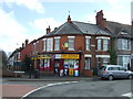
Living in CV6 3GB offers access to a range of nearby amenities, including five retail outlets such as Aldi Radford, Asda Coventry, and Morrisons Daily, ensuring convenience for daily shopping needs. The area’s rail network connects residents to key locations like Coventry Arena and Tile Hill, while the proximity to Coventry Airport enhances travel options. The Coventry Canal, though not detailed in its current use, adds a historical and recreational element to the area. Locally, the Radford Brook runs underground, with remnants of past industrial activity visible in developments like Electric Wharf, a mixed-use site on the former Sandy Lane power station. The war memorial and Nauls’ Mill Park provide points of interest, offering a blend of history and green space. The area’s compact size means amenities are within practical reach, supporting a lifestyle that balances suburban comfort with urban accessibility.
Amenities
Schools
| Rank | School | Type | Entry gender | Ages |
|---|
Explore more schools in this area
Go to Schools tabDemographics
The population of CV6 3GB is 1,841, with a median age of 47, indicating a mature demographic. The most common age range is adults aged 30–64, suggesting a stable community with a focus on family and long-term residency. Home ownership in the area stands at 41%, a figure that reflects a mix of owner-occupied properties and rental stock. The predominant accommodation type is houses, though the data does not specify the proportion of flats or other housing types. The predominant ethnic group is White, which aligns with broader trends in the West Midlands. The lower home ownership rate may indicate a higher proportion of rental properties or shared ownership schemes, though specific data on this is not provided. The absence of detailed diversity statistics means the area’s social composition remains largely unexplored in the data, but the presence of local authority housing, now managed by Whitefriars Housing Group, suggests a historically working-class demographic.
Household Size
Accommodation Type
Tenure
Ethnic Group
Religion
Household Composition
Age
Household Deprivation
NS-SEC
Explore more demographic insights in this area
Go to Demographics tabPlanning
Planning Constraints
- Flood RiskPremium
- Ramsar Wetland SitesPremium
- Area of Outstanding Natural BeautyPremium
- Protected Nature ReservePremium
- Protected WoodlandPremium