Area Overview for CV6 1WY
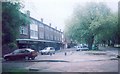
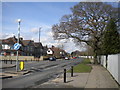
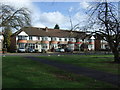
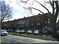
Photos of CV6 1WY


Area Information
CV6 1WY is a small residential postcode area in Coventry, part of the historic Sherbourne Ward. Nestled near the River Sherbourne, which has shaped the area for over a millennium, it blends medieval heritage with modern living. The population of 1,606 reflects a tight-knit community, with homes predominantly occupied by owners. The area’s compact size means residents share proximity to local amenities, schools, and transport links. Historically, the River Sherbourne once caused flooding, but today it is a quiet feature of the landscape. The ward’s boundaries include streets like Sherbourne Street and Hales Street, with remnants of 19th-century drainage projects still visible. Living here offers a mix of practicality and heritage, with easy access to Coventry’s urban infrastructure while retaining a distinct local character. The median age of 47 suggests a stable, family-oriented demographic, with many residents likely working in nearby sectors such as retail, transport, or manufacturing.
- Area Type
- Postcode
- Area Size
- Not available
- Population
- 1606
- Population Density
- 7367 people/km²
The property market in CV6 1WY is characterised by high home ownership (79%) and a focus on houses rather than flats. This suggests a market skewed towards owner-occupied properties, with limited rental activity. The concentration of houses implies a preference for larger, more permanent homes, which may cater to families or individuals seeking stability. Given the small size of the postcode area, the housing stock is likely limited, potentially making the market competitive for buyers. The absence of specific data on property prices or availability means the market’s dynamics are not fully quantified, but the high ownership rate indicates a community that values long-term investment. For buyers, this area may offer a sense of security in a low-turnover market, though the small size could mean limited options for those seeking diverse property types.
House Prices in CV6 1WY
No properties found in this postcode.
Energy Efficiency in CV6 1WY
The lifestyle in CV6 1WY is shaped by its proximity to retail, transport, and historical sites. Residents have access to five retail venues, including Tesco Coventry and Morrisons Coundon, offering everyday shopping convenience. The area’s rail network, with five stations, connects to Coventry’s urban core and surrounding regions, facilitating commuting or leisure trips. While no parks or recreational facilities are explicitly listed, the River Sherbourne runs through the ward, providing a historical backdrop. The compact nature of the area means amenities are within walking or short driving distance, fostering a sense of community. The mix of retail, transport, and heritage features contributes to a practical, accessible lifestyle, ideal for those prioritising convenience without sacrificing connection to the city’s infrastructure.
Amenities
Schools
Residents of CV6 1WY have access to three primary schools: Coundon Primary School, Coundon Junior School, and Coundon Infant School. Coundon Primary School holds a ‘good’ Ofsted rating, reflecting its effectiveness in education. The presence of both junior and infant schools ensures a seamless transition for children through early years to primary education. This cluster of schools provides families with multiple options for their children’s schooling, reducing the need for long commutes. The focus on primary education suggests the area is well-suited for families with young children, though no secondary schools are listed in the data. The quality of Coundon Primary School, in particular, may be a key draw for prospective buyers prioritising educational standards.
| Rank | School | Type | Entry gender | Ages |
|---|
Explore more schools in this area
Go to Schools tabDemographics
The population of CV6 1WY is 1,606, with a median age of 47. The most common age range is adults aged 30–64, indicating a mature, established community. Home ownership is high at 79%, reflecting a strong preference for property investment over rental living. The area is dominated by houses rather than flats, which aligns with the demographic profile of older, settled households. The predominant ethnic group is White, though no data is provided on minority representation. This age group and ownership pattern suggest a low turnover of residents, with many families likely raising children in the area. The absence of specific deprivation data means the quality of life can be inferred from the stability of the population and the availability of local services. The community appears to prioritise long-term residency over transient living.
Household Size
Accommodation Type
Tenure
Ethnic Group
Religion
Household Composition
Age
Household Deprivation
NS-SEC
Explore more demographic insights in this area
Go to Demographics tabPlanning
Planning Constraints
- Flood RiskPremium
- Ramsar Wetland SitesPremium
- Area of Outstanding Natural BeautyPremium
- Protected Nature ReservePremium
- Protected WoodlandPremium