Area Overview for CV5 9WU
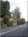
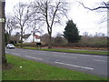
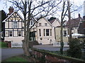
Photos of CV5 9WU


Area Information
CV5 9WU is a compact residential postcode in England, home to 1562 residents spread across a densely populated area with 615 people per square kilometre. This small cluster of homes is characterised by a mature demographic, with a median age of 47 and a majority of residents aged 30–64. The area is predominantly owner-occupied, with 85% of homes owned by their residents, and most properties are houses rather than flats. Daily life here is shaped by proximity to essential services, including five retail outlets such as Tesco Coventry and Co-op Sutherland, and five railway stations, including Canley and Tile Hill. The postcode’s location offers convenient access to Coventry’s transport network, with two nearby airports, though their practical relevance may depend on travel needs. Families and professionals seeking a balanced lifestyle may find the area’s mix of local amenities and connectivity appealing, though the relatively small population suggests a tight-knit community with limited anonymity.
- Area Type
- Postcode
- Area Size
- Not available
- Population
- 1562
- Population Density
- 615 people/km²
The property market in CV5 9WU is dominated by owner-occupied homes, with 85% of properties owned by residents rather than rented out. This suggests a stable, long-term market with limited turnover, which can be both an advantage and a challenge for buyers. The area’s housing stock is primarily composed of houses, which may appeal to families or those seeking more space than flats. However, the small population and compact nature of the postcode mean the available stock is limited, and competition for properties could be fierce. Buyers should consider the area’s proximity to amenities like schools and transport, which may enhance its appeal. The lack of rental properties indicates a community focused on permanence, though this could also mean fewer options for those seeking flexibility.
House Prices in CV5 9WU
No properties found in this postcode.
Energy Efficiency in CV5 9WU
Living in CV5 9WU offers access to a range of amenities within walking or short driving distance. Retail options include five shops such as Tesco Coventry and Co-op Sutherland, providing essentials and convenience. The area’s railway stations, including Canley and Tile Hill, connect residents to broader transport networks, facilitating commutes to work or leisure. While the nearby airports may not be major hubs, they could serve niche travel needs. The absence of detailed data on parks or leisure facilities means their availability is unclear, but the compact nature of the postcode suggests a focus on local shops and transport over expansive recreational spaces. The mix of retail and transport options supports a practical, community-oriented lifestyle, though residents may need to travel further for more specialised amenities.
Amenities
Schools
Residents of CV5 9WU have access to several educational institutions, including Keresley Grange Primary School, which holds an Ofsted rating of ‘good’, and Coundon Court School and Community College, rated ‘satisfactory’. The area also includes The Grange Education Unit and Coundon Court Academy, which may cater to specific needs or age groups. The presence of multiple primary schools suggests a strong local focus on early education, while the academy model may offer alternative teaching approaches. Families seeking a range of options may benefit from the mix of state and academy schools, though the ‘satisfactory’ rating at Coundon Court indicates room for improvement. Proximity to these institutions is a key consideration for parents prioritising education quality.
| Rank | School | Type | Entry gender | Ages |
|---|
Explore more schools in this area
Go to Schools tabDemographics
The residents of CV5 9WU are predominantly adults aged 30–64, with a median age of 47, reflecting a mature, stable population. Home ownership is high at 85%, indicating a community of long-term residents rather than transient renters. The area’s accommodation is largely composed of houses, which contrasts with regions dominated by flats or apartments. The predominant ethnic group is White, though specific data on diversity or deprivation is not provided. The age profile suggests a focus on family life, with schools and local amenities likely serving a significant portion of the population. The absence of detailed data on income or deprivation means broader quality-of-life implications remain unquantified, but the high home ownership rate and mature demographic suggest a community prioritising stability and established living over rapid change.
Household Size
Accommodation Type
Tenure
Ethnic Group
Religion
Household Composition
Age
Household Deprivation
NS-SEC
Explore more demographic insights in this area
Go to Demographics tabPlanning
Planning Constraints
- Flood RiskPremium
- Ramsar Wetland SitesPremium
- Area of Outstanding Natural BeautyPremium
- Protected Nature ReservePremium
- Protected WoodlandPremium