Area Overview for CV5 6TJ
Photos of CV5 6TJ


Area Information
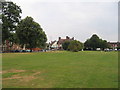
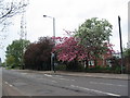
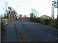
CV5 6TJ is a small residential postcode area in England, part of the suburban ward of Earlsdon, located approximately one mile southwest of Coventry City Centre. With a population of 1,522, it reflects a compact, tightly knit community characterised by its historical roots as a planned garden village. Established in 1852 by the Coventry Freehold Land Society, the area was originally developed for watchmakers and industrialists, leaving a legacy of modest homes and quiet streets. Today, it balances its heritage with modern living, offering proximity to Coventry’s urban amenities while retaining a distinct suburban charm. The area’s layout, with streets like Earlsdon Street and Moor Street, hints at its 19th-century origins. Residents benefit from easy access to Coventry’s transport networks, including nearby railway stations and the city’s motorways, while local landmarks such as Spencer Park and the Earlsdon Clock provide a sense of continuity with the past. The mix of older and newer housing, combined with a population skewed toward middle-aged adults, suggests a stable, community-oriented environment.
- Area Type
- Postcode
- Area Size
- Not available
- Population
- Not available
- Population Density
- Not available
The property market in CV5 6TJ is characterised by a 57% home ownership rate, with houses forming the predominant accommodation type. This suggests a suburban market where private ownership is common but not universal, leaving a notable rental segment. The area’s small size and historical development mean housing stock is limited, with fewer new builds compared to larger urban areas. Buyers should consider that the market may be more competitive for owner-occupied properties, given the lower proportion of rentals. The focus on houses rather than flats or apartments aligns with the area’s low-density, garden village origins. For those seeking property, the limited supply means proximity to Coventry’s city centre or nearby suburbs like Tile Hill could be necessary. The 57% ownership rate also implies a degree of stability, but buyers should be mindful of the area’s small footprint and potential constraints on availability.
House Prices in CV5 6TJ
No properties found in this postcode.
Energy Efficiency in CV5 6TJ
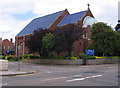
Living in CV5 6TJ offers access to a range of amenities within walking or short driving distance. Retail options include Heart of England Co-operative, Iceland, and Aldi, providing everyday shopping convenience. The area’s rail connections, with stations like Canley and Tile Hill, link residents to Coventry’s city centre and further afield, supporting both commuting and leisure travel. Local landmarks such as Spencer Park, St. Barbara’s Church, and the Earlsdon Clock add historical and cultural depth to daily life. The presence of public houses like the Royal Oak and the City Arms suggests a social scene rooted in tradition, though no specific dining options are listed. The area’s mix of retail, transport, and heritage sites creates a balance between practicality and character, making it appealing for those seeking suburban convenience with a touch of history.
Amenities
Schools
Nearby schools include Kenderdine Montessori School, an independent institution, and Copsewood Education Trust, categorised as “other.” While no Ofsted ratings are provided, the presence of both independent and state-funded options suggests a range of educational choices for families. Kenderdine Montessori’s independent status may appeal to parents seeking alternative curricula or smaller class sizes, while Copsewood’s designation as “other” could indicate a specialist or community-focused school. The mix of school types reflects the area’s diversity, though the lack of detailed performance data means parents must rely on personal visits or local recommendations. For families prioritising specific educational philosophies, the availability of an independent school is a notable feature, but the absence of comprehensive ratings or student outcomes leaves some uncertainty about academic standards.
| Rank | School | Type | Entry gender | Ages |
|---|---|---|---|---|
| 1 | Kenderdine Montessori School | independent | N/A | N/A |
| 2 | Copsewood Education Trust | other | N/A | N/A |
Explore more schools in this area
Go to Schools tabDemographics
The population of CV5 6TJ is 1,522, with a median age of 47 years, indicating a community dominated by adults aged 30–64. Home ownership sits at 57%, suggesting a mix of long-term residents and newer buyers, though not a majority owner-occupied area. The predominant accommodation type is houses, reflecting a suburban rather than high-density profile. The majority of residents identify as White, with no specific data on other ethnic groups provided. This age profile implies a population largely in their prime working years, potentially supporting local services and amenities. The absence of detailed deprivation data means the area’s economic resilience or challenges remain unquantified, but the median age and home ownership rate suggest a relatively stable demographic. The lack of younger families or elderly residents may influence the local school population and community dynamics, though nearby schools like Kenderdine Montessori School cater to broader needs.
Household Size
Accommodation Type
Tenure
Ethnic Group
Religion
Household Composition
Age
Household Deprivation
NS-SEC
Explore more demographic insights in this area
Go to Demographics tabPlanning
Planning Constraints
- Flood RiskPremium
- Ramsar Wetland SitesPremium
- Area of Outstanding Natural BeautyPremium
- Protected Nature ReservePremium
- Protected WoodlandPremium
- Crime RiskPremium