Area Overview for CV5 6HY
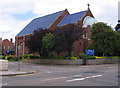
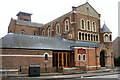
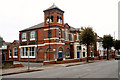
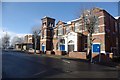
Photos of CV5 6HY


Area Information
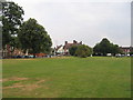
CV5 6HY represents a specific residential cluster within Whoberley Ward, Coventry, covering an area of 463 square metres. Although the recorded population is 1,461, the high population density figure reflects the precise geographical footprint of this postcode rather than a traditional city borough. This location lies to the west of central Coventry, positioned near the modern by-pass and historically associated with Hearsall Common. The area encompasses what was once Whoberley Hall, an ancient moated house noted in 1850, which sits adjacent to the current housing estate and playing fields. Living in CV5 6HY means residing in an area with deep historical roots dating back to at least 1250, when William de Olney held a tenement in nearby Asthill and Olney. The modern settlement grew as urban expansion reshaped Hearsall Common, incorporating Earlsdon suburb into the wider fabric of the city. You are essentially living in a compact pocket of West Midlands history that has evolved into a modern residential zone. The proximity to the by-pass and the remnants of the old common create a distinct environment where historical heritage meets contemporary housing development. This specific postcode area offers a clear connection to Coventry's past while providing the amenities of a growing urban centre.
- Area Type
- Postcode
- Area Size
- 463 m²
- Population
- 1461
- Population Density
- 5220 people/km²
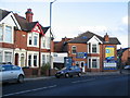
The property market in CV5 6HY is characterised by a mix of tenancy and ownership, with 41 per cent of residents owning their homes. The remaining majority likely rent, reflecting the young median age of 22 years. Accommodation types are listed as houses, which contrasts with the extremely high population density metric of 3,152,679 people per square kilometre. This density suggests the physical layout of the homes maximises space within the 463 square metre postcode area. Homes in CV5 6HY are situated within the Whoberley Ward, an area centred historically around postcode CV1 3GY but administered as a distinct residential cluster today. The presence of a historical moated site and former hall indicates that some properties may have heritage significance or be located near sites of local interest. Buyers looking at this specific area should expect a housing stock that blends older historical elements with modern housing estates. The predominance of houses suggests family-sized or semi-detached properties may be more common in this sector than flats. However, the high density implies efficient land use, potentially including terraced housing or multi-unit developments. This small area functions as a concentrated residential hub rather than a dispersed neighbourhood. The 41 per cent ownership rate is typical for areas with young populations, indicating a market where first-time buyers and landlords operate alongside existing owners.
House Prices in CV5 6HY
No properties found in this postcode.
Energy Efficiency in CV5 6HY
Residents of CV5 6HY have practical access to a range of amenities within easy reach. Retail options include the Heart of England Co-operative Co, Iceland Coventry, and Aldi Unit 8 and 9 Central. These five retail outlets provide essential shopping needs without requiring long journeys. For commuters, rail connections are substantial, with access to Canley Railway Station, Tile Hill Railway Station, and Coventry Arena Railway Station. These five railway stations facilitate easy travel to broader parts of Coventry and beyond. Two airports, both listed as Coventry Airport, are also noted in the vicinity for travel purposes. The proximity to these five transport hubs and five retail locations means daily errands and work commutes are manageable. Living in CV5 6HY allows you to access these services without leaving the immediate local area. The Heart of England Co-operative Co serves the local grocery and community needs. Iceland Coventry and Aldi provide further food and household shopping variety. The five railway stations expand mobility options significantly for residents who need to travel elsewhere. This concentration of amenities defines the convenience of life in this postcode.
Amenities
Schools
Families in CV5 6HY have access to two key educational institutions within the immediate vicinity. Hearsall Community Primary School serves the younger children in the area. It is a primary school located near the residential cluster. For older children, Hearsall Community Academy stands as a secondary academy. This academy holds a Good Ofsted rating, which confirms its standard of education meets national expectations. The combination of a primary school and a rated academy means residents do not need to travel far for schooling. Having both a primary and an academy nearby reduces commute times for parents juggling school runs. The Ofsted Good rating for Hearsall Community Academy provides assurance regarding academic quality for secondary education. Living in CV5 6HY places you within practical reach of these educational facilities. The proximity reduces travel time significantly compared to schools further out in the wider Coventry area. For families prioritising education, the presence of these two schools makes the location attractive. The mix of a community primary and an academy reflects a standard local education structure. These schools are the main anchors for the children growing up in the area.
| Rank | School | Type | Entry gender | Ages |
|---|
Explore more schools in this area
Go to Schools tabDemographics
The community in CV5 6HY is defined by its young demographic, with a median age of just 22 years. Most residents fall into the young adult bracket between 15 and 29 years of age. Home ownership stands at 41 per cent, indicating a significant portion of residents rent their properties. The predominant ethnic group in the area is White. Accommodation types are primarily houses, though the density suggests a concentration of smaller residential units within the defined postcode boundary. A population density of 3,152,679 people per square kilometre underscores the intense concentration of individuals within this specific 463 square metre cluster. This youthful profile suggests the area attracts students or young professionals, consistent with the median age statistic. The high density relative to the very small area size indicates that CV5 6HY functions as a tightly packed residential node rather than a sprawling suburb. Residents here are likely accustomed to close proximity to their neighbours. The data clearly shows that this is an area where younger families and individuals dominate the housing landscape. The specific age range of 15 to 29 years shapes the social dynamics, implying a community focused on early career or educational stages of life.
Household Size
Accommodation Type
Tenure
Ethnic Group
Religion
Household Composition
Age
Household Deprivation
NS-SEC
Explore more demographic insights in this area
Go to Demographics tabPlanning
Planning Constraints
- Flood RiskPremium
- Ramsar Wetland SitesPremium
- Area of Outstanding Natural BeautyPremium
- Protected Nature ReservePremium
- Protected WoodlandPremium