Area Overview for CV47 2PT
Photos of CV47 2PT


Area Information
Living in CV47 2PT means residing within a specific residential cluster located in the historic market town of Southam, Warwickshire. This postcode covers an area of 17.6 hectares and is home to a population of 2,490 people. The density here stands at 287 people per square kilometre, reflecting a compact but spacious feel compared to urban centres Southam surrounds. You are situated in a civil parish that dates back to the Domesday Book, where the area was first recorded as Sucham. The location retains its character as a rural market town nestled along an ancient drovers route, offering a quiet atmosphere distinct from the wider West Midlands region. Historical landmarks shape the daily environment, including the Grade I listed 14th-century parish church of St James and the early 16th-century Old Mint public house. This setting provides a grounded experience where past and present intersect. The town sits roughly 18 miles from a postcode ranging from B79 to B83, placing it within the broader English landscape while maintaining a distinct local identity. Residents of CV47 2PT navigate life in a setting where history is visible on every corner, from the medieval coinage history of the Old Mint to the preserved architecture of local manors.
- Area Type
- Postcode
- Area Size
- 17.6 hectares
- Population
- 2490
- Population Density
- 287 people/km²
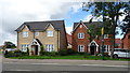
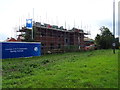
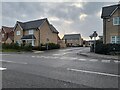
The housing market in CV47 2PT is characterised by a strong owner-occupier base. Seventy-seven per cent of households own their homes, which creates a market driven by residents rather than landlords or short-term rentals. Consequently, the available homes in CV47 2PT are predominantly houses, fitting the rural and suburban character of Southam. This dominance of house ownership suggests that supply may be limited, as private owners are less inclined to move quickly without significant market motivation. Buyers looking at this area should expect a selection of properties where the original purchasers often remain. The accommodation type data confirms that there are no flats or modern apartments listed for this specific postcode, reinforcing the traditional English market town housing stock. This landscape means competition for suitable homes in CV47 2PT could be fierce among competing local buyers. Price trends often reflect the cost of maintaining historic properties rather than new builds. When evaluating homes in CV47 2PT, you are entering a market where property values are supported by low crime rates and high safety scores rather than urban convenience. The market behaviour reflects a desire for stability and permanence among the majority of residents.
House Prices in CV47 2PT
Showing 6 properties
Energy Efficiency in CV47 2PT
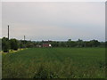
Daily life in CV47 2PT benefits from convenient access to essential retail and community facilities within practical reach. There are five key amenities nearby, including Tesco Southam, the Heart of England Co-operative Co, and Co-op Bishops. These venues ensure that your grocery shopping and weekly retail needs are met without extensive travel. The presence of these specific supermarket chains confirms that you can stock up on household essentials right next to your home in Southam. Beyond the shops, the lifestyle here is shaped by the historic character of the town, featuring landmarks like Stoneythorpe Hall and Chesterton Windmill. The bustling market square serves as a central point for social interaction and community events. You can explore local history through sites such as the Holy Well and the Southam Heritage Collection, which preserve the area's past. This mix of practical retail options and deep historical charm defines the resident experience. The 150,000-hectare countryside surrounding the town also offers opportunities for walking and relaxation beyond the immediate commercial sphere. Living here blends the convenience of modern shopping with the quiet atmosphere of a preserved medieval settlement.
Amenities
Schools
Families moving to CV47 2PT have access to local education through specific institutions in the surrounding area. The nearest schools to this postcode are St Mary's Catholic Primary School, Southam. This institution type covers the primary education phase for younger children in the community. With two entries listed, the presence of St Mary's Catholic Primary School, Southam signifies a dedicated focus on Catholic education within the local catchment area of Southam. There are no secondary schools explicitly named in the immediate vicinity data for this cluster, meaning older children may need to travel further for high school education. The primary school presence indicates that families with young children can access education close to their homes in CV47 2PT. The reliance on a single primary institution suggests a tight-knit educational community where student numbers are concentrated. When considering schools near CV47 2PT, the specific provision of Catholic primary education is a key factor for your decision. The data highlights St Mary's Catholic Primary School, Southam as the definitive local option, ensuring that primary-aged residents receive schooling without commuting long distances to other villages.
| Rank | School | Type | Entry gender | Ages |
|---|
Explore more schools in this area
Go to Schools tabDemographics
The community in CV47 2PT is defined by a mature demographic profile, with a median age of 47 years. You will find that the most common age range among adults spans from 30 to 64 years, indicating a population that has largely settled down. This contrasts with younger, transient urban areas and suggests a neighbourhood where long-term residents dominate. Home ownership is the norm, with 77% of households owning their properties outright or with a mortgage. This high rate of ownership typically correlates with greater investment in local improvements and community stability. The predominant ethnic group in the area is White, aligning with the broader rural profile of Warwickshire. Accommodation types are exclusively houses, meaning you will not see blocks of flats or apartments in this cluster. The absence of high-density housing contributes to the low population density of 287 people per square kilometre. These figures describe a neighbourhood where residents likely know their neighbours and where family longevity is common. The data confirms a stable, settled community structure typical of established market towns rather than development zones seeking regeneration.
Household Size
Accommodation Type
Tenure
Ethnic Group
Religion
Household Composition
Age
Household Deprivation
NS-SEC
Explore more demographic insights in this area
Go to Demographics tabPlanning
Planning Constraints
- Flood RiskPremium
- Ramsar Wetland SitesPremium
- Area of Outstanding Natural BeautyPremium
- Protected Nature ReservePremium
- Protected WoodlandPremium