Area Overview for CV4 9PW
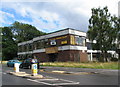
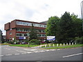
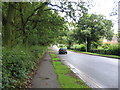
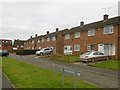
Photos of CV4 9PW
Area Information
CV4 9PW is a compact residential postcode area in Coventry, England, covering just 1.4 hectares and home to 1,498 residents. Its high population density of 103,971 people per square kilometre reflects a tightly knit community. Situated in the Woodlands Ward, the area benefits from historical ties to Coventry’s medieval cloth and wool industries, though modern life here is defined by its proximity to local amenities and transport links. The area’s small size means it is a self-contained cluster, with residents likely to know their neighbours. The median age of 47 suggests a mature demographic, with adults aged 30-64 forming the largest group. This makes CV4 9PW a stable, established community, ideal for those seeking a quiet, well-connected residential environment without the sprawl of larger urban areas.
- Area Type
- Postcode
- Area Size
- 1.4 hectares
- Population
- 1498
- Population Density
- 2517 people/km²
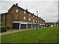
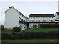
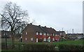
CV4 9PW is a small, owner-occupied area, with 52% of properties owned by residents rather than rented. The accommodation type is predominantly houses, which is unusual for modern urban areas and suggests a more traditional, low-density housing stock. This contrasts with the high population density, indicating that properties are likely to be multi-generational or shared. The compact size of the area means that the housing market is limited, with buyers needing to consider nearby neighbourhoods for more options. For those seeking a home in CV4 9PW, the focus on owner-occupation and house-based living may appeal to families or those prioritising space and stability. However, the small footprint of the postcode means competition for properties is likely to be fierce.
House Prices in CV4 9PW
No properties found in this postcode.
Energy Efficiency in CV4 9PW
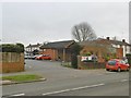
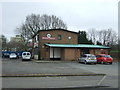
The lifestyle in CV4 9PW is shaped by its proximity to retail, rail, and air travel. Local shops include Farmfoods Allesley, Budgens Jardine, and Spar, offering everyday essentials. The nearby rail stations—Tile Hill, Canley, and Berkswell—provide easy access to public transport, while Coventry Airport is within reach. These amenities create a practical, convenience-focused daily life, though the area’s small size means leisure options are limited to what is immediately available. The lack of parks or cultural venues in the data suggests that residents may need to travel to nearby towns for more varied activities. Despite this, the compact nature of the area fosters a sense of community, with local shops and transport links forming the backbone of daily life.
Amenities
Schools
Residents of CV4 9PW have access to three schools within practical reach. Our Lady of the Assumption Catholic Primary School is a primary school with a ‘good’ Ofsted rating, offering a faith-based education. Tile Hill Wood School and Language College is another primary school, though its Ofsted rating is not specified. West Coventry Academy is an academy with a ‘good’ rating, providing secondary education. The mix of primary and secondary schools ensures families can access education from early years through to adolescence. The presence of both Catholic and state-run schools reflects the area’s diversity in educational options, though the lack of data on school capacity or performance beyond Ofsted ratings means further research may be needed for detailed comparisons.
| Rank | School | Type | Entry gender | Ages |
|---|
Explore more schools in this area
Go to Schools tabDemographics
The population of CV4 9PW is predominantly White, with 52% of residents owning their homes. The area’s median age of 47 indicates a mature demographic, with the majority of residents falling within the 30-64 age range. This suggests a community of established professionals and families, rather than students or younger renters. The high home ownership rate reinforces a sense of stability, though the lack of specific data on household types or diversity means the area’s full demographic profile remains partially unexplored. The absence of detailed information on deprivation or income levels means it is difficult to assess the area’s economic challenges, but the presence of primary and secondary schools indicates a focus on family-oriented living.
Household Size
Accommodation Type
Tenure
Ethnic Group
Religion
Household Composition
Age
Household Deprivation
NS-SEC
Explore more demographic insights in this area
Go to Demographics tabPlanning
Planning Constraints
- Flood RiskPremium
- Ramsar Wetland SitesPremium
- Area of Outstanding Natural BeautyPremium
- Protected Nature ReservePremium
- Protected WoodlandPremium