Area Overview for CV4 9PN
Photos of CV4 9PN

Area Information
Living in CV4 9PN offers a compact, residential experience within the historic city of Coventry. With a population of 1,652, this postcode area is a small cluster of homes, likely centred around the Woodlands Ward. The area’s character is shaped by its medieval roots, when Coventry thrived as a hub for cloth and wool industries. Today, it blends historical significance with modern practicality. Residents benefit from proximity to Tile Hill and Berkswell railway stations, offering easy access to nearby towns. The area is served by Limbrick Wood Primary School, a key local institution, and its schools are among the most notable features. While the population is modest, the community is likely tight-knit, with a median age of 47 and a majority of residents aged 30–64. Digital connectivity is strong, with broadband rated at 100/100, ensuring seamless online access. However, crime rates sit at a medium level, requiring standard precautions. For those seeking a balance between urban convenience and historical context, CV4 9PN presents a focused, practical option.
- Area Type
- Postcode
- Area Size
- Not available
- Population
- 1652
- Population Density
- 4108 people/km²
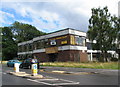
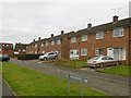
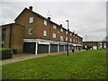
The property market in CV4 9PN is characterised by a low home ownership rate of 37%, suggesting that the area is predominantly a rental market. The accommodation type is primarily flats, which may reflect the area’s urban or semi-urban setting and its focus on compact, efficient housing. This configuration implies that the housing stock is likely to be older, with a mix of purpose-built and converted properties. For buyers, the small size of the area means that the immediate surroundings may offer limited options, particularly for owner-occupied properties. The predominance of flats may also indicate a higher demand for rental properties, potentially leading to competitive conditions for those seeking to purchase. Prospective buyers should consider the practical implications of a rental-heavy market, including potential restrictions on property availability and the need for flexibility in housing choices.
House Prices in CV4 9PN
Showing 3 properties
| Address | Type | Beds | Baths | Last Sale Price | Last Sale Date | |
|---|---|---|---|---|---|---|
| Tile Hill Primary Care Centre, Jardine Crescent, Coventry, CV4 9PN | primary_healthcare | - | - | - | - | |
| Limbrick Wood Medical Practice, Tile Hill Primary Care Centre, Jardine Crescent, Coventry, CV4 9PN | commercial | - | - | - | - | |
| Bhandal Dental Practice, Tile Hill Primary Care Centre, Jardine Crescent, Coventry, CV4 9PN | commercial | - | - | - | - |
Energy Efficiency in CV4 9PN
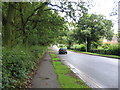
The lifestyle in CV4 9PN is shaped by its proximity to retail, transport, and minor airports. Nearby retail options include Farmfoods Allesley, Budgens Jardine, and Co-op Sutherland, offering everyday shopping convenience. The area’s rail stations provide access to Coventry and beyond, supporting both daily commutes and weekend excursions. Two airports, both named Coventry Airport, are within reach, though their operational details are unclear. For leisure, the area’s historical and cultural context, including Woodlands School’s heritage, adds depth to local life. While parks and open spaces are not explicitly mentioned, the absence of environmental constraints like AONB or protected woodlands suggests that outdoor activities may be feasible nearby. The mix of retail, transport, and historical sites creates a balanced lifestyle, blending practicality with local character.
Amenities
Schools
The nearest school to CV4 9PN is Limbrick Wood Primary School, listed three times in the data, which may indicate its prominence in the area. As a primary school, it serves the local community, providing education for younger children. The absence of secondary schools in the immediate vicinity means that families may need to look further afield for secondary education. However, the presence of a dedicated primary school suggests that the area is well-served for early years education. The school’s historical significance, as noted in the research, adds to its value as a community institution. For families prioritising proximity to schools, Limbrick Wood Primary School offers a reliable option, though the lack of secondary schools may influence long-term housing decisions.
| Rank | School | Type | Entry gender | Ages |
|---|
Explore more schools in this area
Go to Schools tabDemographics
The demographic profile of CV4 9PN reflects a mature, settled community. The median age of 47, with the most common age range being adults aged 30–64, suggests a population that is largely established in careers and family life. Home ownership is relatively low at 37%, indicating that a significant proportion of residents rent their homes. The predominant accommodation type is flats, a common feature in urban or semi-urban areas. The predominant ethnic group is White, though specific diversity statistics are not provided. The area’s small population of 1,652 means that community dynamics are likely close-knit, with limited deprivation data to suggest that quality of life is not significantly impacted by socioeconomic factors. This profile aligns with a residential area that prioritises stability over rapid change, offering a quiet, structured environment for its residents.
Household Size
Accommodation Type
Tenure
Ethnic Group
Religion
Household Composition
Age
Household Deprivation
NS-SEC
Explore more demographic insights in this area
Go to Demographics tabPlanning
Planning Constraints
- Flood RiskPremium
- Ramsar Wetland SitesPremium
- Area of Outstanding Natural BeautyPremium
- Protected Nature ReservePremium
- Protected WoodlandPremium