Area Overview for CV4 9DW
Photos of CV4 9DW


Area Information
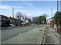
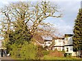
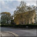
Westwood Ward is an electoral ward located in the southwest of Coventry, West Midlands, England. This specific area, identified by the postcode CV4 9DW, forms part of the suburb of Westwood Heath. It originally developed from the Stoneleigh Estate hamlet and became part of Coventry in 1927 under the Coventry Corporation Boundary Extension Act. The definition of this locality as a semi-rural area transitioning to suburban development remains accurate today. The resident cluster covers an area size of 8135 square metres, containing a population of 1316 people. Living in CV4 9DW means residing in a community that retains semi-rural elements while functioning as a suburb of the larger city. The neighbourhood features enclosed farmland and ribbon housing alongside later 20th-century development, including business parks. This small residential cluster offers a distinctive character that differs from densely built urban centres. Historical records reference this location dating back to 1250 in the Stoneleigh Rolls, noting its association with Stoneleigh Estate and medieval common land. You enter a space where history meets modern suburban convenience. The area includes notable features such as St John the Baptist Church and sites of lost settlements like Hurst village. Your daily life here is shaped by this unique blend of a suburban existence within Coventry. Homes in CV4 9DW benefit from being part of a ward with deep historical roots stretching back to the Knights Templars and the Leigh family. The transition from agricultural land to a residential ward creates a specific atmosphere for those seeking a Coventry home without the full intensity of the city centre. Understanding the character of Westwood Heath is essential before committing to a property in this specific postcode sector.
- Area Type
- Postcode
- Area Size
- 8135 m²
- Population
- 1316
- Population Density
- 5038 people/km²
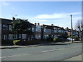
Homes in CV4 9DW reflect the established character of Westwood Ward within Coventry City Council. The accommodation type is primarily houses, a fact reinforced by the 81% homeownership rate recorded for the postcode. This high ownership percentage indicates that the local property market is dominated by owner-occupiers rather than landlords. Buyers searching for properties in this area can expect to find stock suited to families, given the prevalence of houses over flats or terraced units. The semi-rural elements of the ward, including enclosed farmland and historical farm sites, likely influence the style and location of these homes. Properties along Westwood Heath Road and Cromwell Lane, dating back to the 1930s, contribute to the housing mix with ribbon development. Later 20th-century development adds to the stock, creating a varied set of options for purchasers. When viewing properties near CV4 9DW, you will find a mix of older suburban homes and potentially newer extensions. The area is not characterised by high-rise apartments or urban density but by residential clusters that value space. The small area size of 8135 square metres limits the total volume of properties available, making each home significant. This scarcity often drives competition for specific addresses. The market here is stable, driven by a population where eight in ten residents own their property. Buyers looking for rental investments may find limited opportunities compared to districts with higher tenancy rates. Conversely, those looking to move up or consolidate wealth find a market aligned with established householders. The dwelling types in CV4 9DW are a direct result of the area's evolution from an agricultural hamlet to a suburban ward.
House Prices in CV4 9DW
Showing 34 properties
| Address | Type | Beds | Baths | Last Sale Price | Last Sale Date | |
|---|---|---|---|---|---|---|
| 301 Tile Hill Lane, Coventry, CV4 9DW | Terraced | 3 | 1 | £175,000 | Apr 2025 | |
| 321 Tile Hill Lane, Coventry, CV4 9DW | Terraced | 3 | 2 | £247,000 | May 2024 | |
| 319 Tile Hill Lane, Coventry, CV4 9DW | Terraced | 3 | 1 | £217,500 | Jun 2023 | |
| 279 Tile Hill Lane, Coventry, CV4 9DW | house | - | - | £225,000 | Jan 2022 | |
| 273 Tile Hill Lane, Coventry, CV4 9DW | house | - | - | £200,000 | Sep 2021 | |
| 283 Tile Hill Lane, Coventry, CV4 9DW | house | - | - | £191,000 | Jun 2021 | |
| 325 Tile Hill Lane, Coventry, CV4 9DW | house | - | - | £175,000 | Jul 2019 | |
| 293 Tile Hill Lane, Coventry, CV4 9DW | house | - | - | £155,000 | Apr 2018 | |
| 299 Tile Hill Lane, Coventry, CV4 9DW | Terraced | 3 | 1 | £149,950 | Aug 2017 | |
| 309 Tile Hill Lane, Coventry, CV4 9DW | house | - | - | £140,000 | Nov 2016 |
Energy Efficiency in CV4 9DW
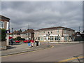
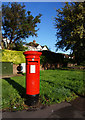
Your daily lifestyle in CV4 9DW is supported by a range of amenities within practical reach. Retail options are plentiful, with five notable venues including the Heart of England Co-operative Co, Sainsburys Canley, and Costco Coventry. These supermarkets and groceries provide access to daily necessities without a long drive. For train commuters, five railway stations serve the wider area, offering direct links via Canley station, Tile Hill station, or Berkswell station. These transport hubs are key to your connection with the rest of the West Midlands. Coventry Airport is located nearby, accessible via two airport points listed in the region. This proximity allows for occasional travel or business trips without significant detours from your home in Westwood Heath. The area retains a semi-rural feel, yet it is not isolated from commercial services. The presence of these specific retailers means you can shop for larger quantities or specialty items locally. Dining options near the Sainsburys store will also offer casual eateries for quick meals. Living in CV4 9DW gives you the convenience of urban shopping with the convenience of fewer crowds. The walkable distance to these amenities reduces the need for a car for routine errands. Yet, the area remains residential, so you will not be overwhelmed by high-street noise. The balance of retail convenience and suburban quietness defines the lifestyle here. You have access to major chains like Costco while avoiding the traffic glare of the main city centre. This practical accessibility enhances the quality of life for families who need reliable access to goods and transport.
Amenities
Schools
| Rank | School | Type | Entry gender | Ages |
|---|
Explore more schools in this area
Go to Schools tabDemographics
The community within CV4 9DW is defined by a clear age profile and strong homeownership rates. The median age of residents is 47 years, reflecting a population dominated by adults aged between 30 and 64 years. This demographic suggests a neighbourhood populated by established households rather than young professionals or retirement-age residents. Homeownership stands at 81%, indicating that the vast majority of people in this postcode own their homes outright or have a mortgage. This high ownership level contrasts with typical rental-heavy districts and suggests stability within the local community. The predominant form of accommodation consists of houses, aligning with the 1930s ribbon housing and later 20th-century developments found in Westwood Heath. Ethnically, White is the predominant group in this area, matching the broader suburban character of the West Midlands. With a population density of 161778 people per square kilometre, the area feels relatively compact for a residential cluster of 8135 square metres. The age range of 30 to 64 years explains why family-friendly properties and single-family homes dominate the stock. You are looking at an area where long-term residents have put down roots. The demographic data confirms that this is a settled community rather than a transient one. The concentration of adults in their working years also implies a demand for homes that support established families. These figures paint a picture of a conventional British suburban neighbourhood where ownership is the norm and families form the backbone of local life.
Household Size
Accommodation Type
Tenure
Ethnic Group
Religion
Household Composition
Age
Household Deprivation
NS-SEC
Explore more demographic insights in this area
Go to Demographics tabPlanning
Planning Constraints
- Flood RiskPremium
- Ramsar Wetland SitesPremium
- Area of Outstanding Natural BeautyPremium
- Protected Nature ReservePremium
- Protected WoodlandPremium