Area Overview for CV34 5PX
Photos of CV34 5PX


Area Information
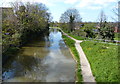
CV34 5PX is a small residential postcode in Warwick, a historic town in Warwickshire, England. Nestled on the River Avon, it benefits from the town’s strategic position, which has shaped its character for centuries. With a population of 1,675, the area is compact, offering a quiet, community-focused lifestyle. Warwick itself is steeped in history, from its 9th-century origins as a Saxon burh to its iconic Warwick Castle, a medieval fortress that remains a focal point for residents and visitors alike. The area’s proximity to the river and surrounding roads connects it to major towns like Stratford, Coventry, and Leamington Spa, blending historic charm with practical accessibility. Daily life here is defined by a mix of traditional and modern influences, with a strong emphasis on local amenities and a stable, middle-aged population. The presence of nearby rail stations and a high broadband score ensures connectivity, while the town’s heritage adds a distinct cultural layer. For those seeking a balanced mix of history, convenience, and community, CV34 5PX offers a compelling proposition.
- Area Type
- Postcode
- Area Size
- Not available
- Population
- 1675
- Population Density
- 3018 people/km²
The property market in CV34 5PX is characterised by a high rate of home ownership (59%) and a predominance of houses over flats or apartments. This reflects the area’s traditional, suburban nature, with properties likely to be family homes rather than high-density housing. The small postcode area suggests a limited number of available properties, which could make the market competitive for buyers. With a population of 1,675, the demand for housing is balanced against the supply, potentially offering stability for those seeking long-term investment. The focus on owner-occupied homes indicates a community of established residents, though the 41% rental market suggests some flexibility for buyers looking to enter the area. The absence of large-scale developments or new builds means the housing stock remains largely unchanged, preserving the historic character of the town while catering to those prioritising stability and traditional living.
House Prices in CV34 5PX
No properties found in this postcode.
Energy Efficiency in CV34 5PX
The lifestyle in CV34 5PX is shaped by its proximity to a range of amenities within practical reach. Retail options include M&S Guyscliffe Warwick BP, Heart of England Co-operative Co, and Morrisons Daily, offering everyday shopping and convenience for residents. The area’s rail connections to Warwick, Parkway, and Leamington Spa provide access to broader networks, supporting both local and regional travel. While the data does not mention parks or leisure facilities, the town’s historic character and nearby natural landmarks—such as the River Avon—suggest opportunities for outdoor activities. The presence of a nursery and retail hubs indicates a focus on family-friendly living, with daily needs met by nearby venues. The compact size of the postcode means amenities are closely clustered, contributing to a sense of convenience and community cohesion.
Amenities
Schools
The nearest school to CV34 5PX is Warwick Nursery School, a nursery providing early education for young children. No other schools are listed in the data, so families with older children may need to look beyond the immediate area for primary or secondary education. The presence of a nursery indicates support for young families, though the lack of additional schools suggests limited options for older children. For those prioritising proximity to educational institutions, the area may require supplementary research into nearby schools in Warwick or surrounding towns. The absence of Ofsted ratings or specific details about the nursery’s performance means potential buyers should consider visiting or contacting local education authorities for further information.
| Rank | School | Type | Entry gender | Ages |
|---|
Explore more schools in this area
Go to Schools tabDemographics
The population of CV34 5PX has a median age of 47, with the majority of residents aged 30–64. This suggests a community of established professionals and families, rather than a younger or elderly demographic. Home ownership is high at 59%, indicating a stable housing market with a significant proportion of owner-occupied properties. The area is predominantly composed of houses, rather than flats or apartments, which aligns with the traditional character of Warwick. The predominant ethnic group is White, with no specific data provided on other ethnicities. While no deprivation figures are listed, the high home ownership and age profile suggest a relatively affluent and settled population. The absence of specific diversity data means the community’s composition remains largely defined by its historical and cultural context, with a focus on long-term residents and local families.
Household Size
Accommodation Type
Tenure
Ethnic Group
Religion
Household Composition
Age
Household Deprivation
NS-SEC
Explore more demographic insights in this area
Go to Demographics tabPlanning
Planning Constraints
- Flood RiskPremium
- Ramsar Wetland SitesPremium
- Area of Outstanding Natural BeautyPremium
- Protected Nature ReservePremium
- Protected WoodlandPremium