Area Overview for CV3 2JF
Photos of CV3 2JF
Area Information
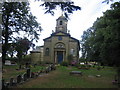
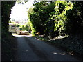
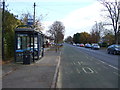
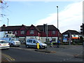
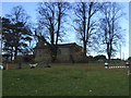
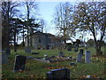
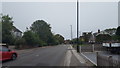
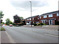
CV3 2JF is a compact residential postcode in the south-eastern part of Coventry, encompassing parts of Binley and Willenhall. Covering just 2.5 hectares, it is densely populated, with 1,345 residents living at a density of 53,840 people per square kilometre. This area has evolved from a historic mining village into a mix of private and council-owned homes, reflecting its roots as a working-class community. Binley, in particular, has a long history dating back to the Domesday Book, with landmarks like St Bartholomew’s Church and Brandon Wood adding character. Daily life here is shaped by proximity to retail outlets such as Lidl, Morrisons, and Asda, along with rail links to Coventry Arena, Canley, and Bedworth stations. The area’s low crime risk and excellent broadband connectivity make it appealing for those seeking a stable, connected lifestyle without the pressures of larger cities. Its small size means a tight-knit community feel, with amenities and green spaces within easy reach.
- Area Type
- Postcode
- Area Size
- 2.5 hectares
- Population
- 1345
- Population Density
- 3381 people/km²
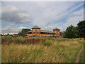
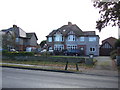
The property market in CV3 2JF is dominated by owner-occupied homes, with 79% of properties owned by residents rather than rented. This high ownership rate indicates a stable and long-term resident base, which can be a positive sign for property value retention. The accommodation type is primarily houses, reflecting the area’s residential focus and historical development as a suburban extension of Coventry. Given the small size of the postcode, the housing stock is limited, but the mix of private and council-owned properties offers a range of options. Buyers should consider the compact nature of the area, which means proximity to amenities and transport links is a key advantage. The presence of nearby industrial estates like Herald Way also suggests potential for future development, though the current market remains firmly residential.
House Prices in CV3 2JF
Showing 25 properties
| Address | Type | Beds | Baths | Last Sale Price | Last Sale Date | |
|---|---|---|---|---|---|---|
| 92 Brandon Road, Coventry, CV3 2JF | house | - | - | £475,000 | Jan 2025 | |
| 82 Brandon Road, Coventry, CV3 2JF | Semi-detached | 3 | 1 | £170,000 | Dec 2024 | |
| 76 Brandon Road, Coventry, CV3 2JF | Semi-detached | 4 | 2 | £228,000 | Jun 2020 | |
| 102 Brandon Road, Coventry, CV3 2JF | Semi-detached | 3 | 1 | £260,000 | Aug 2017 | |
| 104 Brandon Road, Coventry, CV3 2JF | Semi-detached | 2 | 1 | £250,000 | Jun 2016 | |
| 76A Brandon Road, Coventry, CV3 2JF | Detached | 4 | - | £320,000 | Nov 2015 | |
| 70 Brandon Road, Coventry, CV3 2JF | house | - | - | £160,000 | Dec 2013 | |
| 96 Brandon Road, Coventry, CV3 2JF | Semi-detached | 3 | 2 | £141,000 | May 2011 | |
| 78 Brandon Road, Coventry, CV3 2JF | house | 4 | 2 | £160,000 | Sep 2010 | |
| 100 Brandon Road, Coventry, CV3 2JF | house | - | - | £130,000 | Jun 2008 |
Energy Efficiency in CV3 2JF
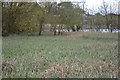
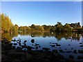
Living in CV3 2JF offers a blend of retail, green spaces, and historical sites. Nearby amenities include supermarkets like Lidl, Morrisons, and Asda Living, ensuring everyday shopping needs are met. The area’s rail links connect residents to Coventry’s cultural and commercial hubs, while nearby airports cater to travel demands. For leisure, Brandon Wood and Willenhall Wood provide accessible green spaces for walking or recreation. The historic St Bartholomew’s Church and the Village Green, established in 1989, add a sense of community and heritage. The area’s compact size means amenities are within practical reach, supporting a convenient, self-contained lifestyle. Whether it’s shopping, commuting, or enjoying local parks, residents have a range of options to enhance daily life.
Amenities
Schools
| Rank | School | Type | Entry gender | Ages |
|---|
Explore more schools in this area
Go to Schools tabDemographics
The population of CV3 2JF is predominantly adults aged 30–64, with a median age of 47. This suggests a mature, established community with a strong presence of families and long-term residents. Home ownership is high at 79%, indicating a stable housing market with a focus on private residences rather than rental properties. The accommodation type is primarily houses, which aligns with the area’s residential character. The predominant ethnic group is White, reflecting the broader demographic trends of the region. While specific data on deprivation is not provided, the high home ownership and low crime risk suggest a generally secure and economically stable environment. The age profile implies a community with a mix of professionals, retirees, and families, contributing to a balanced social fabric.
Household Size
Accommodation Type
Tenure
Ethnic Group
Religion
Household Composition
Age
Household Deprivation
NS-SEC
Explore more demographic insights in this area
Go to Demographics tabPlanning
Planning Constraints
- Flood RiskPremium
- Ramsar Wetland SitesPremium
- Area of Outstanding Natural BeautyPremium
- Protected Nature ReservePremium
- Protected WoodlandPremium