Area Overview for CV3 2FZ
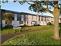
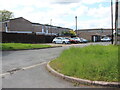
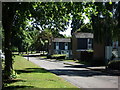
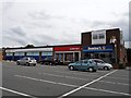
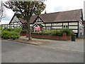
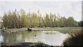
Photos of CV3 2FZ

Area Information
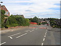
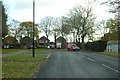
CV3 2FZ lies in the south-eastern part of Coventry, within the Binley and Willenhall ward, a historically rooted residential cluster. The area spans 784 square metres and is home to 1,464 residents, creating a densely populated yet compact community. This postcode covers parts of Binley, a former mining village that evolved into a mix of private and council-owned homes, and Willenhall, which was absorbed into Coventry as the city expanded. Daily life here is shaped by its proximity to retail, transport hubs, and green spaces. The area’s character blends historical legacy with modern convenience, from the 18th-century St Bartholomew’s Church to the industrial Herald Way estate. With a median age of 47 and a strong presence of adults aged 30–64, the community is stable and family-oriented. The high home ownership rate of 86% suggests a long-term commitment to the area, while the predominance of houses over flats reflects a traditional residential layout. Living in CV3 2FZ means balancing urban accessibility with a sense of local identity, anchored by landmarks like Binley Woods and the Village Green.
- Area Type
- Postcode
- Area Size
- 784 m²
- Population
- 1464
- Population Density
- 4115 people/km²
The property market in CV3 2FZ is dominated by owner-occupied homes, with 86% of residents living in properties they own. This high home ownership rate suggests a community of long-term residents rather than a transient rental market. The accommodation type is exclusively houses, with no flats or apartments reported, indicating a traditional, family-friendly housing stock. Given the area’s small size—just 784 square metres—the housing supply is limited, making it a niche market for buyers seeking a compact, established residential area. The predominance of houses may appeal to those prioritising space and privacy over high-density living. Proximity to retail, rail, and green spaces adds to the area’s appeal, though buyers should consider the high population density when evaluating potential properties. The lack of new developments suggests a static market, where property values are likely influenced by historical and local factors rather than speculative growth.
House Prices in CV3 2FZ
Showing 2 properties
| Address | Type | Beds | Baths | Last Sale Price | Last Sale Date | |
|---|---|---|---|---|---|---|
| 129 Princethorpe Way, Coventry, CV3 2FZ | Semi-detached | 3 | 1 | £284,500 | Jul 2023 | |
| 131 Princethorpe Way, Coventry, CV3 2FZ | Semi-detached | 3 | 1 | - | - |
Energy Efficiency in CV3 2FZ
Living in CV3 2FZ offers a blend of convenience and local character. Nearby retail options include Heron Willenhall, Lidl Binley, and Budgens Aldermoor, providing essential shopping within walking distance. The area’s proximity to rail stations—Coventry Arena, Canley, and Bedworth—facilitates easy access to urban amenities and employment hubs. Historically significant sites like St Bartholomew’s Church, a grade I listed building, and Brandon Wood, a publicly accessible ancient woodland, add cultural and recreational value. Willenhall Wood, a nature reserve, offers green space for leisure. The Village Green, established in 1989, hosts community events and children’s activities, fostering a sense of local cohesion. The Binley Mega Chippy and Coombe Social Club, which has served residents since 1929, contribute to the area’s distinct identity. This mix of retail, green spaces, and historical landmarks creates a lifestyle that balances practicality with a connection to the area’s heritage.
Amenities
Schools
| Rank | School | Type | Entry gender | Ages |
|---|
Explore more schools in this area
Go to Schools tabDemographics
The population of CV3 2FZ is 1,464, with a median age of 47, indicating a mature demographic. The majority of residents fall within the 30–64 age range, suggesting a community of established professionals and families. Home ownership is exceptionally high at 86%, reflecting a preference for long-term residency over rental properties. The area is predominantly composed of houses, with no flats reported, aligning with its traditional residential character. The predominant ethnic group is White, though specific data on diversity is not provided. The population density of 1,868,527 people per square kilometre is strikingly high for such a small area, highlighting the compact nature of the postcode. This density, combined with the age profile, implies a mix of nuclear families and older residents. The absence of detailed deprivation data means quality of life indicators like access to services and infrastructure must be inferred from the availability of amenities and transport links. The community’s stability is further underscored by the low crime risk score of 71, which places it below average for safety.
Household Size
Accommodation Type
Tenure
Ethnic Group
Religion
Household Composition
Age
Household Deprivation
NS-SEC
Explore more demographic insights in this area
Go to Demographics tabPlanning
Planning Constraints
- Flood RiskPremium
- Ramsar Wetland SitesPremium
- Area of Outstanding Natural BeautyPremium
- Protected Nature ReservePremium
- Protected WoodlandPremium