Area Overview for CV3 1JL
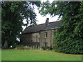
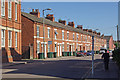
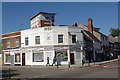
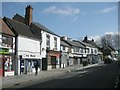
Photos of CV3 1JL


Area Information
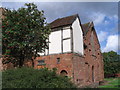
CV3 1JL is a small residential postcode area in Coventry, England, covering just 3.8 hectares and home to 2,799 people. Its high population density of 72,914 people per square kilometre reflects a compact, tightly knit community. Situated to the south-east of Coventry city centre, the area straddles the Coventry-Rugby railway line, with newer housing developments to the north and older industrial estates to the south. Historically rooted in light industry, the area has seen significant redevelopment since the 2000s, with former car manufacturing sites like the Humber and Peugeot factories repurposed for housing. Today, it blends modern residential clusters with remnants of its industrial past, offering proximity to the city’s amenities while retaining a distinct character shaped by its railway alignment and historical alignments like Humber Road. Living here means navigating a mix of practicality and urban convenience, with easy access to transport networks and a community skewed towards middle-aged adults. The area’s small size means every home is within walking distance of key services, though its density can feel intense for those seeking spacious living.
- Area Type
- Postcode
- Area Size
- 3.8 hectares
- Population
- Not available
- Population Density
- Not available
The property market in CV3 1JL is defined by a 50% home ownership rate, with houses forming the dominant accommodation type. This suggests a mix of owner-occupied homes and rental properties, though the small area size means the housing stock is limited. The redevelopment of former industrial sites, such as the Humber and Peugeot factories, has created newer residential clusters, particularly to the north of the railway line. These homes likely include semi-detached or terraced properties, reflecting the area’s compact nature. For buyers, this small postcode area offers a focused selection of homes, but its proximity to Coventry’s city centre means competition for properties could be fierce. The presence of nearby railway stations and retail hubs may make it attractive for commuters, though the lack of larger estates or new builds could limit options. Investors should consider the area’s reliance on its industrial heritage and transport links when assessing long-term value.
House Prices in CV3 1JL
Showing 17 properties
Energy Efficiency in CV3 1JL
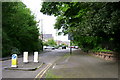
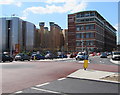
Living in CV3 1JL offers access to a range of nearby amenities, including five retail outlets such as Co-op Humber, Sainsburys Coventry, and Iceland Binley, ensuring everyday shopping needs are met. The area’s proximity to Coventry Airport and multiple railway stations enhances its connectivity, making it convenient for travel or commuting. While the data does not mention parks or leisure facilities, the area’s industrial legacy is reflected in its infrastructure, with former car manufacturing sites repurposed for housing. The compact layout means residents can reach shops, transport hubs, and the city centre within short distances. However, the absence of named parks or recreational spaces suggests a focus on practicality over leisure. The presence of light industrial estates and offices to the south contrasts with the residential north, creating a dynamic but utilitarian lifestyle. Daily life here is shaped by proximity to services, though those seeking extensive green spaces may need to venture beyond the postcode.
Amenities
Schools
| Rank | School | Type | Entry gender | Ages |
|---|
Explore more schools in this area
Go to Schools tabDemographics
The population of CV3 1JL has a median age of 47, with the majority aged between 30 and 64. This suggests a community of established professionals and families, many of whom are likely to have lived in the area for years. Home ownership sits at 50%, indicating a balanced mix of owner-occupied properties and rental housing. The accommodation type is predominantly houses, which, given the area’s compact size, implies a concentration of semi-detached or terraced homes. The predominant ethnic group is White, reflecting broader trends in Coventry’s demographics. The high population density of 72,914 people per square kilometre means residents live in close proximity, which can enhance community interaction but may also impact privacy and space. This density, combined with the area’s history of industrial redevelopment, shapes a lifestyle that prioritises convenience over isolation, with daily life centred around local amenities and transport links rather than expansive green spaces.
Household Size
Accommodation Type
Tenure
Ethnic Group
Religion
Household Composition
Age
Household Deprivation
NS-SEC
Explore more demographic insights in this area
Go to Demographics tabPlanning
Planning Constraints
- Flood RiskPremium
- Ramsar Wetland SitesPremium
- Area of Outstanding Natural BeautyPremium
- Protected Nature ReservePremium
- Protected WoodlandPremium