Area Overview for CV23 9TH
Photos of CV23 9TH


Area Information
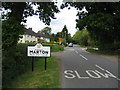
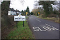
CV23 9TH is a small residential postcode area in Warwickshire, encompassing parts of the village of Marton. With a population of 1,531 and a low density of 65 people per square kilometre, it retains a quiet, village-like character. Situated on the A423 road between Coventry and Southam, the area is bordered by the River Leam and the River Itchen, offering a scenic backdrop. Marton itself has historical roots, appearing in the Domesday Book as *Mortone* and featuring remnants of Iron Age settlements. The village is home to the Marton Museum of Country Bygones, which preserves local rural history. Daily life here is defined by proximity to nature, with easy access to nearby countryside and historical sites. The area’s small size and low population density suggest a close-knit community, though its broader postcode may include surrounding rural clusters. For those seeking a tranquil, historically rich setting with modern amenities, CV23 9TH offers a blend of heritage and practicality.
- Area Type
- Postcode
- Area Size
- Not available
- Population
- 1531
- Population Density
- 65 people/km²
The property market in CV23 9TH is characterised by high home ownership (81%) and a focus on houses rather than flats or apartments. This suggests a predominantly owner-occupied area, likely with older properties reflecting the median age of residents. The small size of the postcode and its rural setting may limit housing stock, making it a niche market for buyers seeking single-family homes. Proximity to the A423 road and nearby towns like Coventry and Southam could enhance its appeal for commuters. However, the limited data on property types or prices means buyers should consider nearby areas for more options. The stability of home ownership and the prevalence of houses indicate a market suited to long-term investment rather than short-term rental opportunities.
House Prices in CV23 9TH
No properties found in this postcode.
Energy Efficiency in CV23 9TH
The lifestyle in CV23 9TH is shaped by its small-scale amenities and rural setting. Nearby retail options include three branches of Heart of England Co-operative Co, providing essential shopping for residents. The area’s proximity to Coventry Airport may offer travel convenience, though it is not a local hub for leisure. The village of Marton itself hosts the Marton Museum of Country Bygones, offering a glimpse into regional history, and the A423 road provides access to surrounding countryside. While the number of amenities is limited, the focus on local shops and historical sites suggests a community prioritising simplicity and heritage over large-scale commercial centres. Daily life here is likely to be low-key, with a reliance on nearby towns for more extensive services.
Amenities
Schools
Near CV23 9TH are two schools: Our Lady’s Catholic Primary School in Princethorpe, rated 'good' by Ofsted, and Princethorpe College, an independent secondary school. The presence of both a primary and an independent school offers families a choice between state and private education. Our Lady’s Catholic Primary’s 'good' rating suggests a reliable foundation for early education, while Princethorpe College caters to older students with a focus on independent learning. The mix of school types may appeal to parents seeking either affordability or specialised curricula. However, no data on secondary state schools is provided, so families reliant on public education may need to look further afield.
| Rank | School | Type | Entry gender | Ages |
|---|
Explore more schools in this area
Go to Schools tabDemographics
The population of CV23 9TH has a median age of 47, with the majority of residents aged between 30 and 64. This suggests a community skewed towards middle-aged adults, likely with established careers and families. Home ownership is high, at 81%, indicating a stable, long-term resident base. The accommodation type is predominantly houses, reflecting a preference for single-family dwellings over flats or apartments. The predominant ethnic group is White, though no specific data on other groups is provided. The age profile and ownership figures imply a mature, settled population with limited turnover. This demographic structure may influence local services and amenities, catering to the needs of older residents and families. The absence of detailed diversity data means the community’s cultural composition remains largely unexplored in the provided information.
Household Size
Accommodation Type
Tenure
Ethnic Group
Religion
Household Composition
Age
Household Deprivation
NS-SEC
Explore more demographic insights in this area
Go to Demographics tabPlanning
Planning Constraints
- Flood RiskPremium
- Ramsar Wetland SitesPremium
- Area of Outstanding Natural BeautyPremium
- Protected Nature ReservePremium
- Protected WoodlandPremium