Area Overview for CV22 6SU
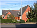
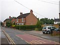
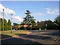
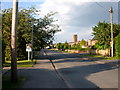
Photos of CV22 6SU

Area Information
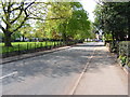
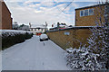
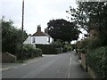
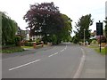
CV22 6SU is a small residential postcode area nestled within the suburban sprawl of Rugby, Warwickshire. With a population of just 1,440, it retains a quiet, village-like character despite being part of a larger town. The area sits approximately 1.5 miles south-west of Rugby’s town centre, historically rooted in the ancient parish of Bilton, which dates back to the Domesday Book. Today, it blends old and new: the surviving village green and 17th-century Bilton Hall stand alongside 1960s housing estates named after naval admirals and Shakespearean figures. Life here is defined by proximity to Rugby’s amenities, yet the sense of community remains strong. The median age of 47 suggests a stable, family-oriented population, with many residents owning their homes. Daily life is shaped by local shops, the nearby railway station, and the quiet charm of a place that has resisted full urbanisation. For those seeking a balance between small-town charm and town access, CV22 6SU offers a distinctive blend of history and practicality.
- Area Type
- Postcode
- Area Size
- Not available
- Population
- 1440
- Population Density
- 4464 people/km²
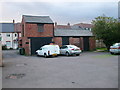
The property market in CV22 6SU is characterised by a high rate of home ownership (76%) and a focus on houses rather than flats or apartments. This suggests a market skewed towards owner-occupied properties, with limited rental availability. The predominance of houses indicates a demand for larger, family-friendly homes, likely catering to the area’s median age group and stable population. As a small postcode area, the housing stock is limited, but the proximity to Rugby offers additional options for buyers seeking larger properties or alternative locations. The 1960s housing estates, such as Admirals Estate and Woodlands Estate, contribute to the local character, blending modernity with historical village features. For buyers, this means a niche market with fewer properties available, but the potential for long-term value retention due to low turnover and the area’s quiet, suburban appeal.
House Prices in CV22 6SU
No properties found in this postcode.
Energy Efficiency in CV22 6SU
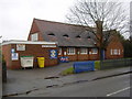
The lifestyle in CV22 6SU is shaped by its mix of suburban convenience and village charm. Nearby amenities include five retail outlets, such as Co-op Overslade, Lidl Bilton, and Heart of England Co-operative Co, offering everyday shopping needs within easy reach. The Rugby Railway Station provides access to broader transport networks, connecting residents to nearby towns and cities. While the data does not mention parks or leisure facilities, the area’s historical village green and proximity to Bilton Hall suggest opportunities for walking, local events, and community engagement. The quiet, low-density nature of the area fosters a relaxed pace of life, with a focus on local shops, family-friendly spaces, and the convenience of nearby town amenities.
Amenities
Schools
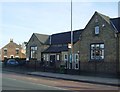
The nearest school to CV22 6SU is Bawnmore Community Infant School, a primary school with a good Ofsted rating. This provides families with a reliable option for early education, though no secondary schools are listed in the data. The presence of a well-rated primary school is a key consideration for families with young children, as it ensures access to quality education without needing to travel far. The school’s good rating suggests a focus on academic standards and student welfare, which aligns with the area’s overall stable and family-oriented demographics. While the data does not mention other educational institutions, the availability of a primary school within practical reach reinforces the area’s appeal to households prioritising schooling for their children.
| Rank | School | Type | Entry gender | Ages |
|---|
Explore more schools in this area
Go to Schools tabDemographics
The community in CV22 6SU is predominantly middle-aged, with a median age of 47 and the most common age range being adults aged 30–64. This suggests a population largely settled in their homes, with fewer young families or elderly residents compared to other areas. Home ownership is high at 76%, indicating a stable, long-term resident base. The accommodation type is primarily houses, reflecting a preference for detached or semi-detached properties over flats. The predominant ethnic group is White, though no further breakdown of diversity is provided. The absence of specific deprivation data means the area’s socio-economic profile is not fully detailed, but the high home ownership rate and age profile suggest a relatively affluent, low-turnover community. This demographic structure supports a quiet, family-focused lifestyle, with fewer transient residents compared to more densely populated urban areas.
Household Size
Accommodation Type
Tenure
Ethnic Group
Religion
Household Composition
Age
Household Deprivation
NS-SEC
Explore more demographic insights in this area
Go to Demographics tabPlanning
Planning Constraints
- Flood RiskPremium
- Ramsar Wetland SitesPremium
- Area of Outstanding Natural BeautyPremium
- Protected Nature ReservePremium
- Protected WoodlandPremium