Area Overview for CV2 5PQ
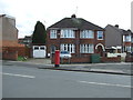
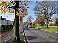
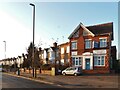
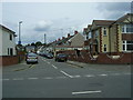
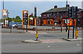
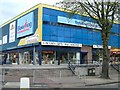
Photos of CV2 5PQ

Area Information
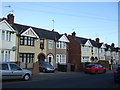
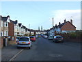
CV2 5PQ is a small residential cluster in the Lower Stoke Ward of Coventry, a metropolitan borough in the West Midlands. With a population of 1,450, it lies to the south-east of Coventry city centre, bordered by the Coventry-Rugby railway line and surrounded by settlements. The area’s character is shaped by its dual nature: newer housing developments to the north, replacing former industrial sites like the Humber and Peugeot factories, and older light industrial estates to the south. Historically tied to Pinley, its Saxon origins and medieval remnants are largely erased by 20th-century development, though traces remain in street alignments and archaeological constraints. Residents benefit from proximity to Coventry’s amenities, with multiple rail stations and retail hubs nearby. The area’s compact size means it’s ideal for those seeking a quieter, semi-urban lifestyle with easy access to the city. Its mix of residential and industrial zones reflects a practical, working-class heritage, with a focus on practicality over historic preservation. For buyers, it offers a slice of Coventry’s evolving landscape, where housing meets convenience.
- Area Type
- Postcode
- Area Size
- Not available
- Population
- 1450
- Population Density
- 3865 people/km²
The property market in CV2 5PQ is dominated by owner-occupied homes, with 71% of properties owned by residents rather than rented. The accommodation type is primarily houses, reflecting a residential area that prioritises family homes over apartments or flats. This suggests a market skewed towards buyers seeking long-term stability, rather than investors targeting rental income. The small size of the area means the housing stock is limited, with redevelopment focused on the northern side, replacing former industrial sites. Buyers should consider the proximity to Coventry’s city centre, which may influence property values and desirability. The mix of newer housing and older industrial infrastructure also means properties may vary in condition, requiring careful inspection. For those seeking a quiet, semi-urban location with practical amenities, CV2 5PQ offers a niche opportunity.
House Prices in CV2 5PQ
No properties found in this postcode.
Energy Efficiency in CV2 5PQ
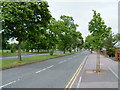
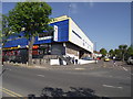
Residents of CV2 5PQ have access to practical amenities within walking or short driving distance. Retail options include Heart of England Co-operative Co, Lidl Upper, and Tesco Ball Hill, offering everyday shopping needs. The area’s rail network connects to multiple stations, enabling easy access to Coventry’s cultural and commercial hubs. While there are no named parks or leisure facilities in the data, the proximity to Coventry suggests access to larger recreational spaces. The presence of two airports, though their relevance is unclear, may indicate logistical convenience. The lifestyle here is pragmatic, with a focus on functional living rather than luxury. The mix of retail, transport, and industrial infrastructure reflects a community prioritising practicality over leisure, though the lack of detailed information on parks or dining options means the full lifestyle picture remains partial.
Amenities
Schools
Residents of CV2 5PQ have access to Caludon Castle School, a primary school and academy with an Ofsted rating of “good,” and the Coventry Extended Learning Centre, which operates as an other-type institution. The presence of both a primary school and a specialist educational facility suggests a range of options for families, from early education to further learning. Caludon Castle School’s good rating indicates a reliable standard of teaching, while the Extended Learning Centre may cater to specific needs such as vocational training or alternative education. However, the absence of secondary schools in the immediate area means families may need to consider commuting to nearby Coventry schools. The mix of school types reflects a practical approach to education, balancing foundational learning with additional support services.
| Rank | School | Type | Entry gender | Ages |
|---|
Explore more schools in this area
Go to Schools tabDemographics
The population of CV2 5PQ is 1,450, with a median age of 47. The majority of residents are adults aged 30–64, reflecting a mature, stable community. Home ownership is high at 71%, indicating a strong presence of long-term residents. The area is predominantly White, with no specific data on other ethnic groups. The accommodation type is primarily houses, suggesting a mix of family homes and single-occupancy properties. The absence of detailed diversity statistics means the community’s full demographic profile remains unclear, but the age range and ownership figures suggest a low turnover of residents. The area’s older population and high home ownership may indicate a focus on settled, family-oriented living. However, the lack of data on deprivation or income levels means it’s difficult to assess broader quality-of-life factors beyond what is explicitly provided.
Household Size
Accommodation Type
Tenure
Ethnic Group
Religion
Household Composition
Age
Household Deprivation
NS-SEC
Explore more demographic insights in this area
Go to Demographics tabPlanning
Planning Constraints
- Flood RiskPremium
- Ramsar Wetland SitesPremium
- Area of Outstanding Natural BeautyPremium
- Protected Nature ReservePremium
- Protected WoodlandPremium