Area Overview for CV2 5DG
Photos of CV2 5DG


Area Information
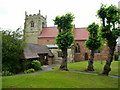
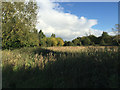
CV2 5DG is a compact residential postcode in the Wyken area of Coventry, England, covering 5,331 square metres and home to 1,450 residents. Its high population density of 272,016 people per square kilometre reflects its small, closely knit character. Historically a medieval village, Wyken evolved from a cluster of farms and terraced homes, with St Mary Magdalene’s Church dating to the early 11th century as a focal point. Today, it blends suburban living with pockets of green space, such as Wyken Slough, a body of water formed by colliery subsidence. The area is part of Coventry’s broader urban fabric but retains a distinct identity, with neighbourhoods like Caludon and Oak Farm. Residents here benefit from proximity to Coventry’s city centre, just three miles away, while the postcode’s small size means it is a quiet, community-focused enclave. With a median age of 47 and a majority of homeowners, CV2 5DG is a stable, family-oriented area where daily life is shaped by local amenities and historical heritage.
- Area Type
- Postcode
- Area Size
- 5331 m²
- Population
- 1450
- Population Density
- 3865 people/km²
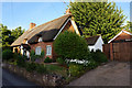
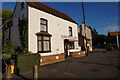
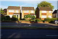
The property market in CV2 5DG is dominated by owner-occupied homes, with 71% of residents owning their properties. This high ownership rate suggests a stable, long-term community with limited rental activity. The accommodation type is primarily houses, which is unusual for a small postcode area but reflects the suburban layout of Wyken. The presence of terraced houses and historical homes, such as Caludon House, indicates a mix of traditional and modern housing stock. Given the area’s small size and high population density, the housing market is likely to be limited in scope, with properties concentrated in established neighbourhoods like Caludon and Oak Farm. For buyers, this means a focus on existing homes rather than new developments, with potential for family-oriented properties in a mature, low-maintenance setting. The compact nature of CV2 5DG also means that proximity to local amenities and transport links is a key consideration for property value.
House Prices in CV2 5DG
No properties found in this postcode.
Energy Efficiency in CV2 5DG
Living in CV2 5DG offers access to a range of amenities within practical reach. Retail options include M&S University Hospital Coventry, Tesco Coventry, and Co-op Woodway, providing everyday shopping convenience. The area’s rail connections, such as Coventry Arena and Canley stations, link residents to broader transport networks, while the presence of two airports, both named Coventry Airport, may offer additional travel options. Historically a rural area, Wyken now features a suburban lifestyle with pockets of green space, such as Wyken Slough, which adds to the area’s charm. The mix of retail, transport, and open spaces creates a balanced lifestyle, suitable for both families and individuals. The compact nature of the postcode means amenities are closely clustered, reducing the need for long commutes. The combination of local shops, transport links, and historical landmarks like St Mary Magdalene’s Church reflects a community that values both practicality and heritage.
Amenities
Schools
The schools near CV2 5DG include Caludon Castle School, which operates as both a primary school and an academy with a good Ofsted rating, and the Coventry Extended Learning Centre, which is categorised as an ‘other’ type of institution. Caludon Castle School’s dual role as a primary and academy suggests it serves a range of age groups, potentially catering to both younger children and older students in the area. The presence of an academy indicates a focus on educational standards, while the Extended Learning Centre may offer alternative or specialist education. Families in CV2 5DG benefit from access to a primary school with a strong rating, though the absence of secondary schools within the postcode means students may need to travel to nearby areas for higher education. The mix of school types reflects a practical approach to meeting local educational needs, though the limited variety may require additional planning for families with older children.
| Rank | School | Type | Entry gender | Ages |
|---|
Explore more schools in this area
Go to Schools tabDemographics
The population of CV2 5DG is 1,450, with a median age of 47 and the most common age range being adults aged 30–64. This suggests a mature, established community with a strong presence of middle-aged residents. Home ownership is high at 71%, indicating a stable housing market and long-term residency for many. The predominant accommodation type is houses, which aligns with the area’s suburban character. The predominant ethnic group is White, though no specific data on diversity or deprivation levels is provided. The high home ownership rate and age profile suggest a community focused on family living and long-term investment. The area’s compact size and density mean it is a tightly knit neighbourhood, where local interactions and shared spaces are likely to be significant. The absence of detailed diversity statistics means the demographic picture remains focused on the core data available.
Household Size
Accommodation Type
Tenure
Ethnic Group
Religion
Household Composition
Age
Household Deprivation
NS-SEC
Explore more demographic insights in this area
Go to Demographics tabPlanning
Planning Constraints
- Flood RiskPremium
- Ramsar Wetland SitesPremium
- Area of Outstanding Natural BeautyPremium
- Protected Nature ReservePremium
- Protected WoodlandPremium