Area Overview for CV2 4HD
Photos of CV2 4HD
Area Information
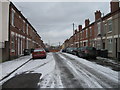
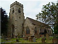
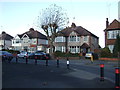
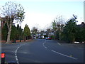
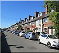
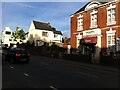
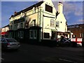
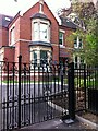
Upper Stoke Ward forms the core of living in CV2 4HD, an area defined by its evolution from medieval open fields to a distinctly suburban settlement. This residential cluster covers 917 square metres and houses a population of 1,870 people. The location retains the character of historic Stoke, featuring small terraced and semi-detached houses set back from the roads with private gardens. Many properties adapt their front gardens for parking, reflecting practical design choices common in this part of Coventry. The ward encompasses remnants of significant historical sites, including the medieval Church of St Michael and the grounds surrounding Caludon Castle. Suburban expansion occurred primarily between the wars, creating the housing stock that residents enjoy today. The postcode CV2 4HD offers a quiet, established environment where daily life balances modern convenience with historical depth. You will find that living in this specific cluster means accessing a mix of open green spaces and dense housing typical of late Victorian and early 20th-century development. The area lies within the wider Wyken and Upper Stoke Character Area, providing a sense of continuity with the city's past while maintaining independent residential identities.
- Area Type
- Postcode
- Area Size
- 917 m²
- Population
- 1870
- Population Density
- 10680 people/km²
Homes in CV2 4HD form a market dominated by rental arrangements rather than ownership. Only 23% of residents own their homes, which indicates a strong presence of private or social tenancies throughout the area. This statistic reflects the types of properties available in CV2 4HD and its immediate surroundings. The accommodation type is overwhelmingly houses, featuring small terraced and semi-detached builds with gardens. These homes are set back from the main roads, a design choice prevalent in the Upper Stoke Ward since its suburban expansion in the early 20th century. For buyers considering this postcode, the low ownership rate implies limited entry-level stock for purchase relative to rental options. The housing stock consists of established properties from the inter-war period, including allocations for munitions workers around 1916. While the specific inventory changes, the character remains consistent with small terraced houses and semi-detached properties. This mix provides a predictable environment where buyers know what to expect regarding layout and setting.
House Prices in CV2 4HD
Showing 12 properties
| Address | Type | Beds | Baths | Last Sale Price | Last Sale Date | |
|---|---|---|---|---|---|---|
| 1, Chandos Court, Chandos Street, Coventry, CV2 4HD | Flat | 2 | 1 | - | - | |
| 2, Chandos Court, Chandos Street, Coventry, CV2 4HD | Flat | - | - | - | - | |
| 8, Chandos Court, Chandos Street, Coventry, CV2 4HD | Flat | - | - | - | - | |
| 11, Chandos Court, Chandos Street, Coventry, CV2 4HD | Flat | - | - | - | - | |
| 9, Chandos Court, Chandos Street, Coventry, CV2 4HD | Flat | 2 | 1 | - | - | |
| 3, Chandos Court, Chandos Street, Coventry, CV2 4HD | Flat | - | - | - | - | |
| 7, Chandos Court, Chandos Street, Coventry, CV2 4HD | Flat | - | - | - | - | |
| 10, Chandos Court, Chandos Street, Coventry, CV2 4HD | Flat | - | - | - | - | |
| 6, Chandos Court, Chandos Street, Coventry, CV2 4HD | Flat | - | - | - | - | |
| 12, Chandos Court, Chandos Street, Coventry, CV2 4HD | Flat | - | - | - | - |
Energy Efficiency in CV2 4HD
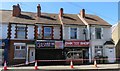
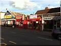
Daily life in CV2 4HD benefits from a practical range of amenities within easy reach. Residents have access to five retail venues, including Heron Upper, Tesco Ball Hill, and Iceland Binley. These shops provide for everyday shopping needs without requiring a long journey. Transport links are well developed, with five nearby railway stations serving the wider region. Coventry Arena Railway Station, Canley Railway Station, and Bedworth Railway Station offer various travel options for commuting. You can also access two airports, Coventry Airport and Coventry Airport, for domestic flights or private aviation needs. This connectivity allows you to leave the ward easily for work or leisure while maintaining a local focus. The proximity of these transport hubs complements the residential nature of Upper Stoke Ward. Living in CV2 4HD means balancing local convenience with quick access to the broader national network.
Amenities
Schools
| Rank | School | Type | Entry gender | Ages |
|---|
Explore more schools in this area
Go to Schools tabDemographics
The community in CV2 4HD centres on adults, with a median age of 47 years. The majority of residents fall within the 30 to 64 years age range, indicating a mature population. Home ownership stands at 23%, meaning the vast majority of households rent their accommodation. The dominant dwelling type is houses, which aligns with the area's layout of properties with rear gardens and setbacks. The predominant ethnic group is White, reflecting the established nature of this part of Coventry. This demographic profile suggests a neighbourhood where stability is key, often attracting families or long-term tenants seeking affordable housing in traditional council or private sectors. With 23% of residents owning their homes, the area likely relies heavily on the private rental market. This heavy rental concentration can create a transient element within the wider fabric of the community. The low ownership rate contrasts with typical suburban expectations, suggesting that CV2 4HD serves as accessible housing for those who do not own property, yet offers the house-based lifestyle many prefer.
Household Size
Accommodation Type
Tenure
Ethnic Group
Religion
Household Composition
Age
Household Deprivation
NS-SEC
Explore more demographic insights in this area
Go to Demographics tabPlanning
Planning Constraints
- Flood RiskPremium
- Ramsar Wetland SitesPremium
- Area of Outstanding Natural BeautyPremium
- Protected Nature ReservePremium
- Protected WoodlandPremium