Area Overview for CV2 3QF
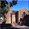
Photos of CV2 3QF
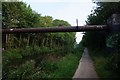
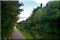
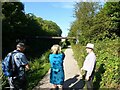
![A stroll along the Coventry Canal to Hawkesbury Junction [19] in CV2 3QF](https://images.propbar.co.uk/images/geograph/71/21/7121157_120.jpg)
Area Information
CV2 3QF is a small residential postcode in Coventry, part of the Wyken and Upper Stoke Character Area. With a population of 2,041, it reflects a historic settlement that evolved from medieval open fields into a suburban cluster of terraced and semi-detached homes. The area’s character is defined by its 17th-century enclosed fields, later adapted for housing with small gardens and road setbacks. Today, it blends historical remnants like the 14th-century Church of St Michael and Grade II-listed Green Farmhouse with modern living. Residents benefit from proximity to Coventry’s rail network, including Canley and Bedworth stations, and nearby retail hubs like Tesco Ball Hill and Aldi Edgwick. Digital connectivity is excellent, with fixed broadband scoring 100 and mobile coverage rated 85. This makes it suitable for remote work and daily internet use. The area’s compact size and suburban layout offer a quiet, community-focused lifestyle, ideal for those seeking a balance between historical charm and practical amenities.
- Area Type
- Postcode
- Area Size
- Not available
- Population
- 2041
- Population Density
- 9533 people/km²
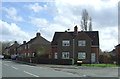
The property market in CV2 3QF is characterised by a 45% home ownership rate, with houses forming the predominant accommodation type. This suggests a modest owner-occupied market, though the relatively low home ownership percentage indicates a significant rental component. The housing stock consists of small terraced and semi-detached properties, many with rear gardens and front gardens adapted for parking. These homes reflect post-war suburban development, offering practical, compact living spaces. For buyers, the limited size of the area and its focus on houses may mean fewer options compared to larger towns, though proximity to Coventry’s rail network and retail hubs adds appeal. The market is likely stable, with properties catering to families or professionals seeking a quieter, suburban lifestyle. However, the lack of high-rise or modern developments may limit growth potential.
House Prices in CV2 3QF
No properties found in this postcode.
Energy Efficiency in CV2 3QF
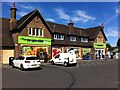
Living in CV2 3QF offers access to practical amenities within reach. Retail options include Heart of England Co-operative Co, Aldi Edgwick, and Tesco Ball Hill, providing everyday shopping needs. The area’s proximity to rail stations like Canley and Bedworth connects residents to Coventry’s cultural and commercial hubs. While no parks or leisure facilities are named in the data, the suburban layout with small gardens suggests a quieter, community-focused lifestyle. The historical character of the area, including the 14th-century Church of St Michael, adds a unique backdrop to daily life. The mix of retail, transport, and historical sites supports a convenient, low-stress environment. However, the absence of specific details on dining or recreational venues means the full range of lifestyle options remains unquantified.
Amenities
Schools
| Rank | School | Type | Entry gender | Ages |
|---|
Explore more schools in this area
Go to Schools tabDemographics
The population of CV2 3QF is 2,041, with a median age of 47. The most common age range is 30–64 years, indicating a mature, stable community. Home ownership stands at 45%, suggesting a mix of owner-occupied and rental properties. The predominant accommodation type is houses, reflecting a suburban layout with small terraced and semi-detached homes. The predominant ethnic group is White, though no specific diversity statistics are provided. The age profile suggests a population largely composed of working-age adults and retirees, with fewer children compared to other areas. This demographic may influence local services and amenities, such as healthcare and leisure facilities. The absence of detailed deprivation data means quality of life factors like access to services or employment opportunities are not quantified here, but the area’s proximity to rail and retail suggests reasonable convenience.
Household Size
Accommodation Type
Tenure
Ethnic Group
Religion
Household Composition
Age
Household Deprivation
NS-SEC
Explore more demographic insights in this area
Go to Demographics tabPlanning
Planning Constraints
- Flood RiskPremium
- Ramsar Wetland SitesPremium
- Area of Outstanding Natural BeautyPremium
- Protected Nature ReservePremium
- Protected WoodlandPremium