Area Overview for CV10 0NU
Photos of CV10 0NU

Area Information
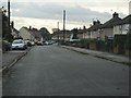
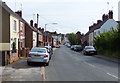
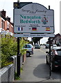
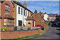
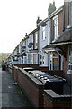
CV10 0NU is a small residential cluster in Nuneaton, Warwickshire, with a population of 2,205. Situated 1.5 miles north-west of Nuneaton town centre, it is a post-war housing estate originally built in the 1950s to accommodate coal miners. The area’s history includes Roman-era remains and the former Camp Hill Hall, a Tudor-style mansion demolished in the 1930s. Today, it is characterised by suburban housing, though regeneration efforts since 1999 have aimed to address longstanding issues of deprivation and economic inactivity. Living here means navigating a community shaped by its industrial past, with a median age of 47 and a population skewed towards adults aged 30–64. While the area lacks the vibrancy of urban centres, its proximity to Nuneaton’s rail network and retail hubs offers practical connectivity. The 80% home ownership rate reflects a stable, long-term resident base, though pockets of challenge remain. For buyers, CV10 0NU presents a mix of affordability and historical context, with a focus on family-oriented housing.
- Area Type
- Postcode
- Area Size
- Not available
- Population
- 2205
- Population Density
- 3854 people/km²
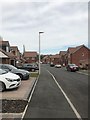
The property market in CV10 0NU is dominated by owner-occupied homes, with 80% of residents living in properties they own. The accommodation type is predominantly houses, reflecting the area’s post-war housing estate origins. This contrasts with rental-heavy markets, where flats or apartments might predominate. The focus on owner-occupation suggests a community of long-term residents, though the housing stock is largely from the 1950s, which may require modernisation. Buyers in CV10 0NU should consider the limited availability of new builds, as the area’s small size and historical character mean development is constrained. The presence of houses rather than apartments may appeal to families seeking space, but the lack of recent construction could limit options for those seeking contemporary features. Proximity to Nuneaton’s amenities and rail links adds value, though the area’s regeneration status means property prices may not reflect its potential for long-term growth.
House Prices in CV10 0NU
No properties found in this postcode.
Energy Efficiency in CV10 0NU
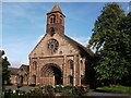
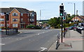
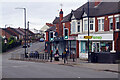
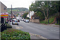
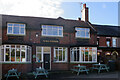
The lifestyle in CV10 0NU is shaped by its suburban character and proximity to Nuneaton’s retail and transport hubs. Within walking distance are five retail outlets, including Heart of England Co-operative Co, Budgens Camphill, and Co-op Sherebourne, providing essential shopping. The area’s rail links, including Nuneaton and Bermuda Park stations, offer access to town centre amenities, dining, and services. While the local character is defined by post-war housing and historical sites like St. Mary’s and St. John’s Church, the immediate surroundings lack large parks or leisure facilities. The presence of community-focused venues, such as the church halls established in the 1950s, suggests a focus on local cohesion. For residents, daily life balances practicality with a sense of familiarity, though the area’s limited green spaces and modest retail options may require trips to Nuneaton for more diverse experiences.
Amenities
Schools
| Rank | School | Type | Entry gender | Ages |
|---|
Explore more schools in this area
Go to Schools tabDemographics
The population of CV10 0NU is predominantly adults aged 30–64, with a median age of 47. Home ownership is high, at 80%, and the area is characterised by houses rather than flats or apartments. The predominant ethnic group is White, with no data provided on minority representation. The area is classified as one of Warwickshire’s most deprived wards, a legacy of its post-war origins and the decline of the coal industry in the 1980s. This deprivation manifests in lower skill levels and economic inactivity, though regeneration efforts since 1999 have aimed to improve infrastructure and services. For residents, this means a community with strong local ties but limited access to high-skilled employment. The 1950s housing stock, while functional, often includes properties in need of renovation, which may affect property values and living standards. The age profile suggests a stable demographic, but the lack of younger families may influence local amenities and school demand.
Household Size
Accommodation Type
Tenure
Ethnic Group
Religion
Household Composition
Age
Household Deprivation
NS-SEC
Explore more demographic insights in this area
Go to Demographics tabPlanning
Planning Constraints
- Flood RiskPremium
- Ramsar Wetland SitesPremium
- Area of Outstanding Natural BeautyPremium
- Protected Nature ReservePremium
- Protected WoodlandPremium