Area Overview for CV10 0HP
Photos of CV10 0HP
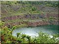
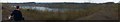
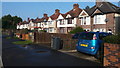
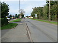
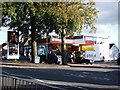
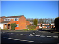
6 photos from this area
Area Information
Key information about the CV10 0HP including its size, population, and administrative classification.
- Area Type
- Postcode
- Area Size
- 19.7 hectares
- Population
- 2302
- Population Density
- 295 people/km²
House Prices in CV10 0HP
33
Properties
£141,132
Average Sold Price
£24,000
Lowest Price
£274,000
Highest Price
Showing 33 properties
| Address | Type | Beds | Baths | Last Sale Price | Last Sale Date | |
|---|---|---|---|---|---|---|
| 149 Mancetter Road, Hartshill, CV10 0HP | Semi-detached | 3 | 2 | £274,000 | Jul 2023 | |
| 135 Mancetter Road, Hartshill, CV10 0HP | house | 2 | 1 | £220,000 | Jun 2023 | |
| 139 Mancetter Road, Hartshill, CV10 0HP | house | 2 | 1 | £210,000 | Feb 2023 | |
| 123 Mancetter Road, Hartshill, CV10 0HP | Semi-detached | 2 | 2 | £190,000 | Dec 2021 | |
| 111 Mancetter Road, Hartshill, CV10 0HP | house | - | - | £155,000 | Jul 2021 | |
| 109 Mancetter Road, Hartshill, CV10 0HP | house | - | - | £165,000 | Dec 2020 | |
| 127 Mancetter Road, Hartshill, CV10 0HP | house | - | - | £168,000 | Dec 2019 | |
| 85 Mancetter Road, Nuneaton, CV10 0HP | house | - | - | £215,000 | Mar 2019 | |
| 105 Mancetter Road, Hartshill, CV10 0HP | Detached | 3 | 2 | £207,000 | Mar 2019 | |
| 95 Mancetter Road, Hartshill, CV10 0HP | Detached | 3 | 1 | £199,950 | May 2018 |
Page 1 of 4
Energy Efficiency in CV10 0HP
Amenities
Schools
| Rank | School | Type | Entry gender | Ages |
|---|
Explore more schools in this area
Go to Schools tabDemographics
Household Size
Two person
most common
Accommodation Type
Houses
most common
Tenure
67
majority
Ethnic Group
White
most common
Religion
N/A
most common
Household Composition
N/A
most common
Age
47
median
Adults (30-64 years)
most common
Household Deprivation
N/A
with no deprivation
NS-SEC
28
in Lower managerial occupations
Explore more demographic insights in this area
Go to Demographics tabPlanning
Planning Constraints
- Flood RiskPremium
- Ramsar Wetland SitesPremium
- Area of Outstanding Natural BeautyPremium
- Protected Nature ReservePremium
- Protected WoodlandPremium