Area Overview for CV1 5YH
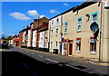
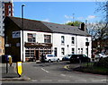
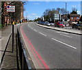
Photos of CV1 5YH


Area Information
CV1 5YH is a small residential postcode in England, home to 1741 people spread across a compact cluster of properties. The area’s character is shaped by its modest size and the demographic profile of its residents, who are predominantly adults aged 30–64. This suggests a community rooted in stability, with many long-term residents. The postcode’s proximity to Coventry’s infrastructure, including rail links and retail hubs, ensures practical connectivity for daily life. While the area does not boast natural landmarks or historical sites, its appeal lies in its accessibility and the balance between residential tranquillity and urban convenience. For those seeking a place to settle, CV1 5YH offers a straightforward, no-frills environment. The presence of two primary schools with good Ofsted ratings adds to its appeal for families. However, the area’s small size means it is best suited for those prioritising proximity to services over expansive green spaces or cultural amenities.
- Area Type
- Postcode
- Area Size
- Not available
- Population
- 1741
- Population Density
- 13382 people/km²
The property market in CV1 5YH is characterised by a focus on houses, with 43% of residents owning their homes. This suggests a mix of owner-occupied properties and rental units, though the exact proportion of rentals is not specified. The prevalence of houses over flats indicates a preference for standalone living, which may appeal to families or individuals seeking space and privacy. Given the area’s small size, the housing stock is likely limited to a few hundred properties, making it a niche market for buyers. The modest home ownership rate could imply a reliance on rental availability, though the data does not confirm this. For prospective buyers, the compact nature of the area means competition may be keen, particularly for properties with good access to nearby amenities like schools and transport links.
House Prices in CV1 5YH
No properties found in this postcode.
Energy Efficiency in CV1 5YH
Residents of CV1 5YH benefit from a range of amenities within easy reach. Five retail outlets, including Co-op Coventry and Sainsburys Coventry, provide everyday shopping convenience. The area’s rail network, with stations such as Canley and Tile Hill, offers straightforward access to commuting routes and regional travel. While the data does not specify dining or leisure venues, the proximity to Coventry’s urban centres likely extends the area’s lifestyle options. The presence of two airports, though unnamed beyond ‘Coventry Airport’, may offer niche travel opportunities. For daily life, the combination of retail, rail, and transport infrastructure ensures a functional, if unremarkable, lifestyle. The area’s compact nature means residents must rely on nearby towns for broader amenities, but the immediate vicinity offers sufficient practicality for routine needs.
Amenities
Schools
Residents of CV1 5YH have access to two primary schools within practical reach: St Benedict’s Catholic Primary School and St Mary and St Benedict Catholic Primary School. Both institutions cater to younger children, with the latter holding a ‘good’ Ofsted rating, indicating a solid standard of education. The presence of two primary schools within the area provides families with options, though the absence of secondary schools nearby means students may need to travel for further education. The Catholic affiliation of both schools may appeal to families with specific religious preferences. For those prioritising educational quality, the ‘good’ rating at St Mary and St Benedict Catholic Primary School is a positive indicator, though no data is available on pupil outcomes or school performance beyond Ofsted ratings.
| Rank | School | Type | Entry gender | Ages |
|---|---|---|---|---|
| 1 | St Benedict's Catholic Primary School | primary | N/A | N/A |
| 2 | St Mary and St Benedict Catholic Primary School | primary | N/A | N/A |
Explore more schools in this area
Go to Schools tabDemographics
The population of CV1 5YH is skewed toward adults, with a median age of 47 and the most common age group being 30–64 years. This reflects a mature, settled community with limited presence of younger families or retirees. Home ownership stands at 43%, indicating a mix of owner-occupied properties and rental units. The predominant accommodation type is houses, which may suggest a preference for standalone homes over flats or apartments. The area’s most common ethnic group is Asian, though specific breakdowns are not detailed. The data does not include deprivation metrics, but the relatively high median age and home ownership rate imply a community with established financial stability. This demographic profile shapes a neighbourhood where routine and continuity are prioritised over rapid change.
Household Size
Accommodation Type
Tenure
Ethnic Group
Religion
Household Composition
Age
Household Deprivation
NS-SEC
Explore more demographic insights in this area
Go to Demographics tabPlanning
Planning Constraints
- Flood RiskPremium
- Ramsar Wetland SitesPremium
- Area of Outstanding Natural BeautyPremium
- Protected Nature ReservePremium
- Protected WoodlandPremium
- Crime RiskPremium