Area Overview for CV1 4PE
Photos of CV1 4PE


Area Information
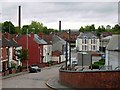
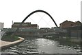
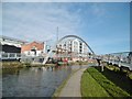
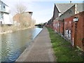
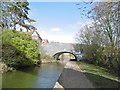
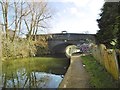
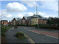
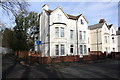
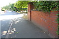
CV1 4PE lies in Radford, a historic suburb of Coventry, just 1.5 miles north of the city centre. With a population of 1,431, it is a compact residential area shaped by its industrial past. The district’s identity is rooted in its role as a hub for motor manufacturing, notably the former Daimler and Jaguar factories that operated until the mid-1990s. Today, the area retains a mix of 20th-century housing, including semi-detached and terraced properties, alongside former council homes. The Radford Brook, flowing underground, and the nearby Coventry Canal add a subtle natural element to the urban landscape. A notable landmark is the 1919 war memorial, commemorating local soldiers from World War I. While the area is small, it offers proximity to Coventry’s transport networks, including multiple railway stations and the city’s motorway links. Its compact size means residents are close to both the city’s amenities and the quieter residential charm of Radford’s streets.
- Area Type
- Postcode
- Area Size
- Not available
- Population
- 1431
- Population Density
- 8704 people/km²
The property market in CV1 4PE is characterised by a 30% home ownership rate, which implies that the majority of housing is rented. The area’s accommodation is predominantly houses, though the exact distribution of semi-detached, terraced, or other formats is not detailed. This suggests a mix of older, post-war housing stock, including former council properties, some of which were transferred to private ownership under the right to buy scheme. The relatively small population and compact size of the area mean that the housing stock is limited, with properties likely to be concentrated in the northern parts of Radford, which developed during the 20th century. For buyers, this presents a niche market with a focus on individual homes rather than larger developments. The historical industrial legacy of the area may also influence property values, with some homes benefiting from proximity to transport links or green spaces like the Coventry Canal.
House Prices in CV1 4PE
No properties found in this postcode.
Energy Efficiency in CV1 4PE
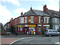
Living in CV1 4PE offers access to a range of local amenities within practical reach. Nearby retail options include major supermarkets such as Tesco Coventry, Sainsburys Coventry, and Iceland Coventry, ensuring everyday shopping needs are met. The area is also served by multiple railway stations, including Canley and Tile Hill, which provide convenient links to Coventry’s city centre and surrounding areas. While no specific parks or leisure facilities are listed in the data, the Coventry Canal runs through the district, offering opportunities for walking or cycling. The Radford Brook, though largely underground, contributes to the area’s subtle natural character. Additionally, the Electric Wharf development, located at the former Sandy Lane power station, adds a modern mixed-use dimension to the local landscape. These amenities collectively support a lifestyle that balances convenience with the quieter aspects of suburban living.
Amenities
Schools
| Rank | School | Type | Entry gender | Ages |
|---|
Explore more schools in this area
Go to Schools tabDemographics
The population of CV1 4PE is 1,431, with a median age of 47 and the majority of residents aged 30–64. This suggests a community with a strong presence of working-age adults, many of whom may be employed in nearby industries or commuting to Coventry’s city centre. Home ownership in the area is relatively low at 30%, indicating that a significant portion of the housing stock is rented. The predominant accommodation type is houses, though the data does not specify the proportion of flats or other formats. The area’s most common ethnic group is listed as Asian_total, reflecting a demographic profile shaped by historical migration patterns. While no specific deprivation data is provided, the combination of low home ownership and an older median age may suggest a community with a mix of long-term residents and newer arrivals, balancing stability with evolving needs.
Household Size
Accommodation Type
Tenure
Ethnic Group
Religion
Household Composition
Age
Household Deprivation
NS-SEC
Explore more demographic insights in this area
Go to Demographics tabPlanning
Planning Constraints
- Flood RiskPremium
- Ramsar Wetland SitesPremium
- Area of Outstanding Natural BeautyPremium
- Protected Nature ReservePremium
- Protected WoodlandPremium