Area Overview for CV1 4PA
Photos of CV1 4PA


Area Information
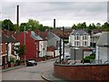
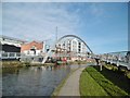
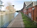
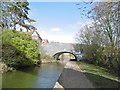
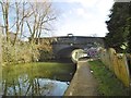
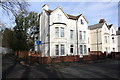
CV1 4PA, a small residential cluster in Radford, Coventry, is a quiet suburb with a population of 1,431. Nestled 1.5 miles north of the city centre, it sits within the broader Coventry metropolitan area. Historically, Radford was central to the British motor car industry, with Daimler and Jaguar factories operating in the 20th century. Today, it retains a suburban character, with housing ranging from semi-detached properties to flats, many of which were former council homes. The area’s war memorial, unveiled in 1919, stands as a poignant reminder of its past, while the Coventry Canal and Radford Brook add a touch of natural continuity. Daily life here balances proximity to Coventry’s urban amenities with a quieter, residential rhythm. With rail links to Canley and Tile Hill stations, and nearby supermarkets like Tesco and Sainsburys, residents enjoy practical connectivity. The postcode’s compact size means it’s ideal for those seeking a blend of historical interest and modern convenience, though its small scale means the housing market is limited to a few distinct options.
- Area Type
- Postcode
- Area Size
- Not available
- Population
- 1431
- Population Density
- 8704 people/km²
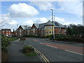
The property market in CV1 4PA is characterised by a 30% home ownership rate, indicating that most properties are rented rather than owner-occupied. The area’s accommodation type is predominantly houses, though the mix includes semi-detached and terraced homes. This suggests a modest housing stock, with limited scope for expansion given the postcode’s small size. The prevalence of former council housing, many transferred to Whitefriars Housing Group in 2000, points to a rental market that may cater to both long-term tenants and younger buyers seeking affordable entry points. However, the low home ownership rate and compact footprint mean the market is niche, with few new developments. Buyers should consider the area’s historical ties to industry and its current role as a suburban outpost, balancing practicality with the challenges of a limited property pool.
House Prices in CV1 4PA
Showing 44 properties
Energy Efficiency in CV1 4PA
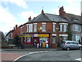
Living in CV1 4PA offers access to essential amenities within walking or short driving distance. Retail options include major supermarkets like Tesco Coventry, Aldi Radford, and Sainsburys Coventry, ensuring daily shopping convenience. The area’s rail stations connect residents to Coventry’s cultural and commercial centres, while proximity to Coventry Airport (listed twice) adds to travel flexibility. Historically, the area’s industrial roots are visible in landmarks like the Electric Wharf development, built on the site of a former power station. The Radford Brook, though culverted, remains a subtle feature of the local geography. While parks and leisure facilities are not explicitly detailed, the nearby Coventry Canal and Belgrade Theatre suggest opportunities for recreation and cultural engagement. The lifestyle here balances practicality with a touch of historical intrigue, ideal for those prioritising accessibility over expansive green spaces.
Amenities
Schools
| Rank | School | Type | Entry gender | Ages |
|---|
Explore more schools in this area
Go to Schools tabDemographics
The population of CV1 4PA is 1,431, with a median age of 47, indicating a mature community. The most common age range is adults aged 30–64, suggesting a stable demographic profile. Home ownership here is relatively low at 30%, meaning many residents rent. The predominant accommodation type is houses, though the mix of semi-detached and terraced properties reflects a blend of private and former council housing. The area’s predominant ethnic group is Asian, which shapes its cultural landscape. While deprivation data is not provided, the 30% home ownership rate implies a reliance on rental markets and social housing. This could influence the area’s affordability and community dynamics, with a focus on long-term tenancies rather than property investment. The age profile also suggests a community with established residents, potentially prioritising stability over rapid growth.
Household Size
Accommodation Type
Tenure
Ethnic Group
Religion
Household Composition
Age
Household Deprivation
NS-SEC
Explore more demographic insights in this area
Go to Demographics tabPlanning
Planning Constraints
- Flood RiskPremium
- Ramsar Wetland SitesPremium
- Area of Outstanding Natural BeautyPremium
- Protected Nature ReservePremium
- Protected WoodlandPremium