Area Overview for CV1 4NY
Photos of CV1 4NY


Area Information
CV1 4NY is a small residential postcode area nestled in Radford, a suburb of Coventry, approximately 1.5 miles north of the city centre. With a population of 1,431, it forms part of the broader Coventry metropolitan area and is characterised by its suburban and residential layout, particularly in the northern sections developed during the 20th century. The area’s history is deeply tied to the motor car industry, with the former Daimler and Jaguar factories once dominating the landscape. Today, the housing stock includes a mix of semi-detached, terraced, and flat properties, many of which were originally council housing. The community is predominantly composed of adults aged 30–64, with a median age of 47, and the Asian_total group representing the largest ethnic cohort. Daily life in CV1 4NY balances proximity to Coventry’s amenities with a quieter, more residential feel, supported by nearby rail links and retail options. The area’s compact size means residents often rely on local services, while its historical industrial roots add a layer of cultural depth to its modern identity.
- Area Type
- Postcode
- Area Size
- Not available
- Population
- 1431
- Population Density
- 8704 people/km²
The property market in CV1 4NY is defined by a 30% home ownership rate, suggesting that a majority of residents rent their homes. The area is predominantly composed of houses, though the exact proportion of flats or other property types is not detailed. This mix implies a range of housing options, from semi-detached and terraced homes to former council properties now managed by private entities like Whitefriars Housing Group. The small postcode area’s limited size means the housing stock is concentrated, with buyers needing to consider nearby suburbs for additional options. The presence of both owner-occupied and rental properties indicates a balanced but modest market. Given the area’s historical association with industrial activity, some properties may have been repurposed or renovated, offering potential for character homes. However, the compact nature of CV1 4NY means competition for available properties could be keen, particularly for those seeking larger or more modern dwellings.
House Prices in CV1 4NY
No properties found in this postcode.
Energy Efficiency in CV1 4NY
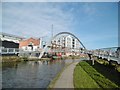
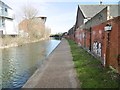
Residents of CV1 4NY have access to a range of amenities within practical reach. The area is served by five retail outlets, including Morrisons Daily, Aldi Radford, and Tesco Coventry, ensuring everyday shopping needs are met. Nearby rail stations such as Coventry Arena, Canley, and Tile Hill provide direct links to Coventry’s city centre and surrounding areas, enhancing connectivity for work, leisure, and travel. The proximity to the Coventry Canal adds a scenic element to local life, though its current use for recreation is not detailed. While the area lacks major parks or green spaces within the postcode, historical sites like the war memorial and Electric Wharf—a mixed-use development—add cultural and community value. The combination of retail convenience, rail access, and historical landmarks contributes to a lifestyle that balances practicality with local heritage.
Amenities
Schools
| Rank | School | Type | Entry gender | Ages |
|---|
Explore more schools in this area
Go to Schools tabDemographics
The population of CV1 4NY is 1,431, with a median age of 47, reflecting a community dominated by adults aged 30–64. Home ownership stands at 30%, indicating a significant proportion of residents rent their homes. The area is predominantly composed of houses, though the exact distribution of household types is not specified. The Asian_total group forms the largest ethnic category, shaping the cultural fabric of the neighbourhood. This demographic profile suggests a mature, stable population with established ties to the area. The relatively low home ownership rate may indicate a mix of long-term renters and those in transitional housing phases. The absence of specific deprivation data means the area’s quality of life is inferred from its amenities and infrastructure, such as rail connectivity and retail access. The presence of a war memorial and historical sites also points to a community with a strong sense of local heritage.
Household Size
Accommodation Type
Tenure
Ethnic Group
Religion
Household Composition
Age
Household Deprivation
NS-SEC
Explore more demographic insights in this area
Go to Demographics tabPlanning
Planning Constraints
- Flood RiskPremium
- Ramsar Wetland SitesPremium
- Area of Outstanding Natural BeautyPremium
- Protected Nature ReservePremium
- Protected WoodlandPremium