Area Overview for Broughton Hackett
Photos of Broughton Hackett
Area Information
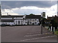
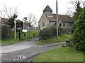
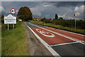
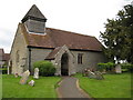
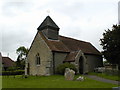
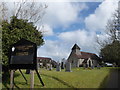
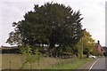
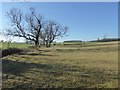
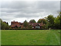
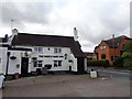
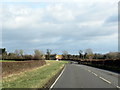
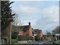
Broughton Hackett is a civil parish located in the Wychavon district of Worcestershire within the West Midlands region of England. The village sits approximately five miles east of Worcester, positioned alongside the Bow Brook river and on the A422 road connecting Worcester to Stratford and Alcester. You will find this is a small rural settlement with a defined area size of 1.6 km², offering a sense of isolation that many seek in countryside living. Historical records indicate the village was documented in the Domesday Book with cottagers and farmers, reflecting its deep roots since the late 12th century when the family holding land established parts of its name. The architecture tells its own story, featuring landmarks such as the Church of St Leonard from the 14th century, a large yew tree, and a listed Church Cottage. A former mill on the Bow Brook adds to the historic character, while the March Hare Inn serves as a local gathering point. Living here means embracing a quiet existence punctuated by specific, tangible heritage rather than modern sprawl. The blend of natural features and ancient structures defines the daily rhythm for those who choose this parish.
- Area Type
- Parish
- Area Size
- 1.6 km²
- Population
- Not available
- Population Density
- Not available
Demographics
The community profile of Broughton Hackett reveals a resident population that skews significantly older than the national average. The median age stands at 70 years, indicating that the dominant head of household represents the senior demographic. This age structure often influences local amenities and community activities, focusing on needs relevant to older adults. Home ownership is prevalent, with 76% of residents owning their properties outright or with a mortgage. This high rate reflects long-term settlement and stability within the parish. While specific breakdowns for household composition and predominant ethnic groups are not detailed in current records, the overall picture points toward a established, possibly intergenerational community. The elderly population may drive demand for accessible housing and local medical services, though these specific requirements depend on individual circumstances. You enter a neighbourhood where the majority of homes have been passed down through families rather than being new builds or rentals. Understanding this demographic makeup helps you anticipate the pace of life and the type of neighbour you are likely to meet in this rural setting.
Household Size
Accommodation Type
Tenure
Ethnic Group
Religion
Household Composition
Age
Household Deprivation
NS-SEC
Explore more demographic insights in this area
Go to Demographics tabPlanning
Planning Constraints
- Flood RiskPremium
- Ramsar Wetland SitesPremium
- Area of Outstanding Natural BeautyPremium
- Protected Nature ReservePremium
- Protected WoodlandPremium
- Crime RiskPremium