Area Overview for Brinklow
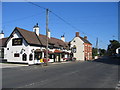
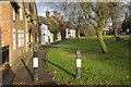
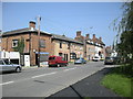
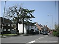
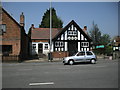
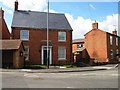
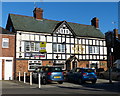
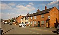
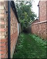
Photos of Brinklow


Area Information
Brinklow is a compact built-up area in England, spanning 39.2 hectares and home to a population with a median age of 70. This suggests a community skewed towards older residents, likely with a strong presence of long-term homeowners. The area is served by a primary school, Brinklow CofE First School, which caters to local families. Daily life here is shaped by proximity to retail hubs like Co-op Wolston and M&S Binley, as well as rail connections to Rugby and Coventry Arena stations. While Brinklow is not a sprawling suburb, its size and amenities offer a blend of convenience and quiet living. The area’s character is defined by its older demographic, with a focus on stability and established neighbourhoods. For those seeking a community with a mature population and accessible services, Brinklow provides a straightforward, practical living environment without the complexities of larger urban areas.
- Area Type
- Built Up Area 250
- Area Size
- 39.2 hectares
- Population
- Not available
- Population Density
- Not available
Brinklow’s residents have access to a range of amenities within practical reach, including five retail outlets such as Co-op Wolston, M&S Binley, and Asda Living. These shops provide convenience for daily errands and leisure shopping. The area’s rail links to Rugby and Coventry Arena stations enhance mobility, while proximity to Coventry Airport offers easy access to regional and national travel. Though the data does not mention parks or leisure facilities, the presence of retail and transport options suggests a lifestyle that balances practicality with accessibility. The mix of shopping, dining, and transport options supports a functional daily routine, making Brinklow a viable choice for those prioritising convenience and connectivity in their living environment.
Amenities
Schools
Brinklow is served by Brinklow CofE First School, a primary school that provides education for younger children in the area. The data does not include Ofsted ratings or secondary school options, so families requiring comprehensive schooling may need to look beyond the immediate vicinity. The presence of a primary school is a key factor for families with young children, though the absence of further educational institutions suggests that secondary education is not locally available. This means that parents may need to consider commuting to nearby towns for secondary schooling, which could be a practical consideration for prospective homebuyers with school-age children.
| Rank | A + A* % | School | Type | Entry gender | Ages |
|---|---|---|---|---|---|
| 1 | N/A | Brinklow CofE First School | primary | N/A | N/A |
Explore more schools in this area
Go to Schools tabDemographics
Brinklow’s population has a median age of 70, reflecting a community dominated by older residents. The most common age range is listed as "Age: Total," indicating a broad distribution, though the high median suggests a significant proportion of retirees. Home ownership stands at 80%, implying a stable, long-term resident base with fewer renters. The data does not specify household composition or accommodation types, but the high home ownership rate points to a community prioritising property as an investment. There is no explicit information on ethnic diversity or deprivation levels, but the absence of such data means these aspects remain unexplored in this analysis. The area’s demographic profile suggests a focus on older, settled residents, with a housing market that reflects long-term occupancy rather than transient populations.
Household Size
Accommodation Type
Tenure
Ethnic Group
Religion
Household Composition
Age
Household Deprivation
NS-SEC
Explore more demographic insights in this area
Go to Demographics tabPlanning
Planning Constraints
- Crime RiskLocked